Jujuy Fuerza Sagrada by UTMBJujuy, Argentina🇦🇷

About Jujuy Fuerza Sagrada by UTMB 2027
Jujuy Fuerza Sagrada by UTMB 2027 is a trail race held from Wed, Mar 31, 2027 to Sun, Apr 4, 2027 in Jujuy, Argentina.
Registration dates have not been announced yet. Dates, registration windows and fees on this page are refreshed every morning by scanning federation, timing and organiser sites; registration always happens on the official race site.
Someone running 30 km a week needs 23 weeks, about 5.5 months, to prepare for the 87.2K course of Jujuy Fuerza Sagrada by UTMB 2027; the latest start is Wed, Oct 21, 2026.
Courses
| Course | Distance | Start | Elevation Gain | Km-effort | Course file |
|---|---|---|---|---|---|
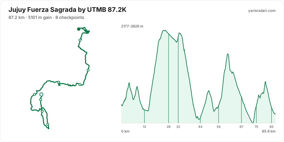
| 87.2K | 87.2 km | Sat 05:00 | 5101 m D+ | 138 | GPX |
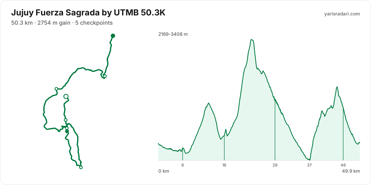
| 50.3K | 50.3 km | Sat 07:00 | 2754 m D+ | 78 | GPX |
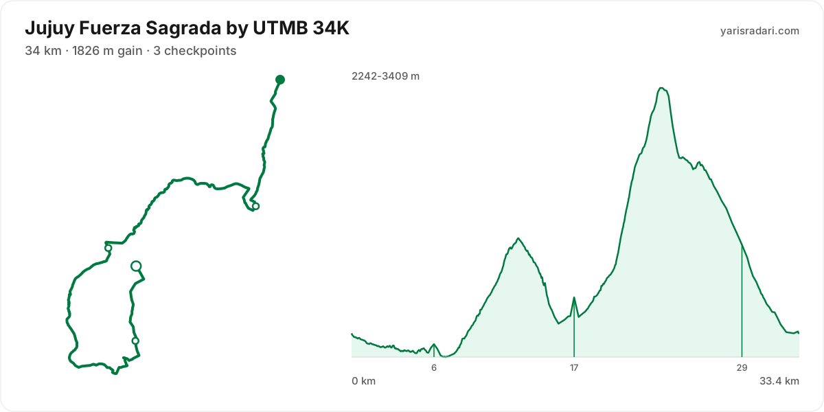
| 34K | 34 km | Fri 07:00 | 1826 m D+ | 52 | GPX |
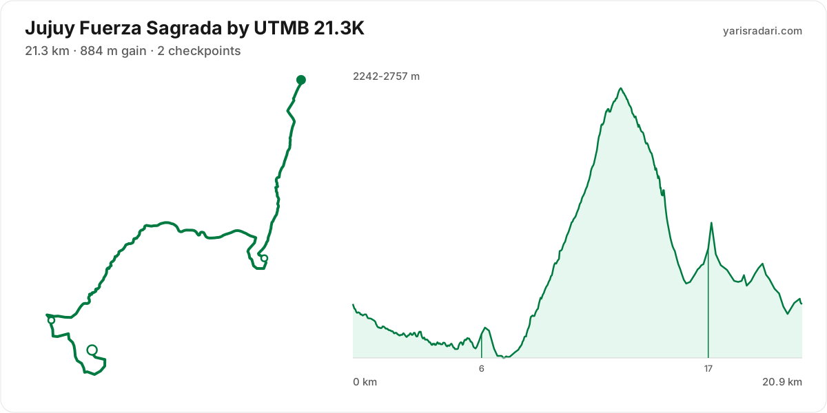
| 21.3K | 21.3 km | Fri 07:30 | 884 m D+ | 30 | GPX |
| 11.9K | 11.9 km | Sun 09:00 | 723 m D+ | 19 | GPX |
| 4.5K | 4.5 km | Sun 10:00 | 175 m D+ | 6 | GPX |
There are 6 courses: 87.2K (5101 m D+); 50.3K (2754 m D+); 34K (1826 m D+); 21.3K (884 m D+); 11.9K (723 m D+); 4.5K (175 m D+).
Course map and elevation profile
What the weather is usually like here
- Over the last 5 years this week typically ran 10°C to 24°C here, with a high of 30°C and a low of 4°C.
- 23% of those days saw rain. A real forecast lands about two weeks out and will appear here then.
- Typical daily maximum wind was 11 km/h (calm), with 16 km/h the highest value in the sample.
- Sunrise 07:30, sunset 19:19.
The race is more than two weeks out, so these are averages of recent years for the same week, not a forecast. A real forecast appears here closer to the day.
Race briefing
87.2K course86 km · 5430 m gain · 41% uphill · 8 aid stations
- Steep climb (10%+)
- Climb (3-10%)
- Flat
- Descent
- Steep descent (12%+)
The published GPX measures 86 km with 5430 m of climbing, 63 m per km. The course sits between 2167 m and 3830 m of altitude. 49% of the gain sits in the first half.
- 0-13 km · Start → PALETA DEL PINTOR: 751 m up / 844 m down; the stretch keeps rolling.
- 13-26 km · PALETA DEL PINTOR → ABRA: 1549 m up / 199 m down; the stretch climbs.
- 26-32 km · ABRA → PUNTA CORRAL: 111 m up / 159 m down; the stretch keeps rolling.
- 32-44 km · PUNTA CORRAL → TUNALITO: 255 m up / 1710 m down; the stretch descends.
- 44-54 km · TUNALITO → LOS COLORADOS: 743 m up / 497 m down; the stretch climbs.
- 54-67 km · LOS COLORADOS → EL PASO: 1088 m up / 954 m down; the stretch keeps rolling.
- 67-75 km · EL PASO → TUMBAYA: 365 m up / 510 m down; the stretch descends.
- 75-83 km · TUMBAYA → EL PASO II: 530 m up / 566 m down; the stretch keeps rolling.
- 83-86 km · EL PASO II → Finish: 38 m up / 152 m down; the stretch descends.
The first 5 km climb 459 m and then drop 176 m. Do not attack the opening climb in the crowd, and do not brake your way down the drop behind it.
The backbone of the course runs from km 15 to km 24: 1432 m over 9.4 km at 15% average, its steepest roughly 250 m section averaging 30%. It tops out at 3829 m. Heaviest kilometres: km 20 234 m, km 16 232 m, km 18 230 m, km 19 210 m. Running is not on the menu at this grade; settle into a hike from the bottom and load the poles, short steps.
The climb between km 52 and km 59: 1016 m over 7.3 km at 14% average, its steepest roughly 250 m section averaging 31% on the GPX trace. It tops out at 3407 m. Heaviest kilometres: km 57 295 m, km 59 205 m, km 58 168 m, km 56 162 m. By the time you start it, about 59% of the day's climbing is behind you. Running is off the table only in the steepest roughly 250 m core; hike that part with short steps and run again once the grade eases.
The steepest wall stands between km 73 and km 80: net 743 m over 6.7 km at 11% average, its steepest roughly 250 m section averaging 31% on the GPX trace, 843 m of climbing in total with 100 m given back. It tops out at 2920 m. Heaviest kilometres: km 80 204 m, km 74 188 m, km 75 154 m, km 76 139 m. By the time you start it, about 84% of the day's climbing is behind you. The hard core of this climb is hiking ground; keep the rest at a steady effort and do not fight the wall when it arrives.
The longest descent starts at km 59 and loses 1217 m by km 73 at 9% average, its steepest roughly 250 m section averaging 41% on the GPX trace. Its length can load the quads, so begin under control and build rhythm only when the ground and visibility allow it. The drop at km 32 averages 27% over its steepest roughly 250 m section; shorten the stride, stay balanced and set speed to the ground instead of braking continuously.
The last 6 km climb 126 m and then drop 624 m. Walk the climb, take the descent back, and hold the sprint until the drop is done.
You reach the climb after PALETA DEL PINTOR with about 844 m of descent already in your quads; treat its first half as recovery effort.
The leg from PALETA DEL PINTOR to ABRA is long and unsupported: 13 km and 1549 m of climbing with no aid in between, so leave PALETA DEL PINTOR with full capacity.
You reach the climb after TUNALITO with about 1710 m of descent already in your quads; treat its first half as recovery effort.
- The organiser lists 87.2 km; the published GPX measures 85.6 km. The organiser lists 5101 m of climbing; the published GPX measures 5430 m. The technical course notes use the published GPX measurement.
- This course reaches 3830 m. At the high-point coordinate, the same week historically ran 2°C to 12°C. Typical daily maximum wind was 8 km/h, reaching 15 km/h in the sample. This is climate history, not the race-day forecast; keep the shell accessible if race week looks similar.
- Start 05:00, sunrise 07:30: the first 2 hours 30 minutes are run in the dark. The headtorch goes on your head at the start, not in your pack.
- Sunset is 19:18, 14 hours 18 minutes after the gun. If your target time is longer than that, carry a headtorch whether or not the rules demand one.
- Poles are strongly recommended for this profile. The course averages 63 m of gain per km and the longest climb averaging over 5% runs 9.4 km; if you have trained with them and the organiser allows them, use them on the climbs and stow them on runnable ground.
- 22% of the course is steep descent. Increase your cadence instead of braking, or your quads go early.
- Arrive early for the altitude. The course tops out at 3830 m, and coming up from sea level on race morning costs you more than any training block gains. Get to the area a few days ahead and let your body adjust.
- The altitude is not a single summit: about 86 km of the course sits above 1800 m, 73 km above 2400 m, 26 km above 3000 m. The longest unbroken stretch up high is 86 km and the high zone spans roughly km 0 to km 86. About 100% of the total climbing happens in that thin air, so recalibrate your effort to the altitude, not the gradient alone.
- Point to point: the finish sits 20.3 km from the start as the crow flies. Sort the shuttle and your drop bag before race day.
Course-profile notes are generated from GPX grade data; terrain, rules, aid stations and weather are added only when separately sourced.
Aid stations
Key decision points
PALETA DEL PINTORkm 13
- Collect food and fluids and leave within 60-90 seconds.
- The heaviest leg is next: 13 km with 1602 m of climbing.
- The longest unsupported stretch starts here: 13 km. Leave with full capacity.
LOS COLORADOSkm 54
- Collect food and fluids and leave within 60-90 seconds.
- A heavy leg is next: 13 km with 1213 m of climbing.
- A 31% pitch starts about 1.8 km after the station; do not enter it cooled down.
EL PASOkm 67
- Take hot food you digest easily and top up fluids.
- Your drop bag waits here; work off your prepared list.
- The longest stretch between official aid stations runs from PALETA DEL PINTOR (km 13) to ABRA (km 26): 13 km, with 1602 m of climbing in between. Top up at PALETA DEL PINTOR and size what you carry to the expected duration and your own drinking rate.
- Hot food is served at EL PASO (km 67). If your stomach and race plan call for it, make this a deliberate 3-5 minute stop; do not sit down simply because hot food is available. Restart gently and let your stomach settle before lifting the effort.
- Food is available at PALETA DEL PINTOR (km 13) and ABRA (km 26) and 5 more. Decide what you need before reaching the table; without a planned special task, collect food and fluids and leave within 60-90 seconds. Finish eating on the next calm, suitable section.
- Drop bag at EL PASO (km 67). Write down the equipment and food you expect to replace before the race so the decision is already made when you arrive.
- Crew support is permitted only at TILCARA (km 0). This is not the same as a drop bag: plan equipment and food hand-offs around these stations, then verify wristband, bag and transport rules with the organiser.
- Another heavy leg runs from LOS COLORADOS (km 54) to EL PASO (km 67): 13 km with 1213 m of climbing. Treat it as the slowest part of your day and get your food out before it.
- Medical support is available at TILCARA (km 0), PALETA DEL PINTOR (km 13), ABRA (km 26), PUNTA CORRAL (km 32), TUNALITO (km 44), LOS COLORADOS (km 54), EL PASO (km 67), TUMBAYA (km 75), EL PASO II (km 83), and PURMAMARCA (km 88). If something is wrong with your feet or your stomach, deal with it there rather than pushing on.
- About 2 km after LOS COLORADOS (km 54), a roughly 250 m section averaging 31% begins. Choose food you know you digest easily and fill the bottles, then enter the climb at a controlled effort.
| Station | Km | From previous | Supplies | Medical | Crew |
|---|---|---|---|---|---|
| TILCARA | 0 | — | — | Yes | Yes |
| PALETA DEL PINTOR | 13 | 13 | Food | Yes | No |
| ABRA | 26 | 13 | Food | Yes | No |
| PUNTA CORRAL | 32 | 5.4 | Food | Yes | No |
| TUNALITO | 44 | 12 | Food | Yes | No |
| LOS COLORADOS | 54 | 10 | Food | Yes | No |
| EL PASODrop bag | 67 | 13 | Hot food | Yes | No |
| TUMBAYA | 75 | 8.3 | Food | Yes | No |
| EL PASO II | 83 | 8.3 | Food | Yes | No |
| PURMAMARCA | 88 | 5 | Hot food | Yes | No |
Aid station details come from the list published by the organiser; confirm them at the official source before race day.
Plan your cutoffs for this course
50.3K course50 km · 2881 m gain · 43% uphill · 5 aid stations
- Steep climb (10%+)
- Climb (3-10%)
- Flat
- Descent
- Steep descent (12%+)
The published GPX measures 50 km with 2881 m of climbing, 58 m per km. The course sits between 2167 m and 3409 m of altitude. 62% of the gain sits in the first half.
- 0-6 km · Start → TUNALITO: 76 m up / 132 m down; gently rolling.
- 6-16 km · TUNALITO → LOS COLORADOS: 623 m up / 472 m down; the stretch climbs.
- 16-29 km · LOS COLORADOS → EL PASO: 1182 m up / 834 m down; the stretch climbs.
- 29-37 km · EL PASO → TUMBAYA: 102 m up / 706 m down; the stretch descends.
- 37-46 km · TUMBAYA → EL PASO II: 862 m up / 342 m down; the stretch climbs.
- 46-50 km · EL PASO II → Finish: 36 m up / 394 m down; the stretch descends.
The first 4 km drop 76 m. Fresh legs make it feel free, but you climb every metre of it back.
The climb between km 7 and km 12: 510 m over 5.1 km at 10% average, its steepest roughly 250 m section averaging 22%. It tops out at 2757 m. Kilometre by kilometre: km 8 42 m, km 9 92 m, km 10 113 m, km 11 106 m, km 12 137 m. This is hiking terrain, not running terrain. Walk it with intent and keep your heart rate off the ceiling.
The backbone of the course runs from km 15 to km 23: 1021 m over 7.7 km at 13% average, its steepest roughly 250 m section averaging 33% on the GPX trace. It tops out at 3407 m. Heaviest kilometres: km 21 295 m, km 23 206 m, km 22 162 m, km 20 159 m. Running is off the table only in the steepest roughly 250 m core; hike that part with short steps and run again once the grade eases.
The late climb from km 37 to km 44: net 734 m over 7 km at 10% average, its steepest roughly 250 m section averaging 29%, 851 m of climbing in total with 117 m given back. It tops out at 2911 m. Heaviest kilometres: km 44 181 m, km 39 175 m, km 40 136 m, km 38 132 m. The hard core of this climb is hiking ground; keep the rest at a steady effort and do not fight the wall when it arrives.
The longest descent starts at km 23 and loses 1230 m by km 37 at 9% average, its steepest roughly 250 m section averaging 42% on the GPX trace. Its length can load the quads, so begin under control and build rhythm only when the ground and visibility allow it. The drop at km 12 averages 28% over its steepest roughly 250 m section; shorten the stride, stay balanced and set speed to the ground instead of braking continuously.
The last 6 km drop 624 m first and then climb 109 m. Empty your legs on the descent and that final rise takes the payment.
A steep pitch starts within about 1.4 km of TUNALITO; keep the stop short and do not enter it on cooled-down legs.
You reach the climb after LOS COLORADOS with about 472 m of descent already in your quads; treat its first half as recovery effort.
The leg from LOS COLORADOS to EL PASO is long and unsupported: 13 km and 1182 m of climbing with no aid in between, so leave LOS COLORADOS with full capacity.
You reach the climb after TUMBAYA with about 706 m of descent already in your quads; treat its first half as recovery effort.
- This course reaches 3409 m. At the high-point coordinate, the same week historically ran 4°C to 14°C. Typical daily maximum wind was 12 km/h, reaching 17 km/h in the sample. This is climate history, not the race-day forecast; keep the shell accessible if race week looks similar.
- Sunset is 19:18, 12 hours 18 minutes after the gun. If your target time is longer than that, carry a headtorch whether or not the rules demand one.
- Poles are strongly recommended for this profile. The course averages 58 m of gain per km and the longest climb averaging over 5% runs 7.7 km; if you have trained with them and the organiser allows them, use them on the climbs and stow them on runnable ground.
- The climbing is stacked into the first half. Start easy; even with less climbing later, the descents and accumulated fatigue still have to be managed.
- Arrive early for the altitude. The course tops out at 3409 m, and coming up from sea level on race morning costs you more than any training block gains. Get to the area a few days ahead and let your body adjust.
- The altitude is not a single summit: about 50 km of the course sits above 1800 m, 34 km above 2400 m, 6 km above 3000 m. The longest unbroken stretch up high is 50 km and the high zone spans roughly km 0 to km 50. About 100% of the total climbing happens in that thin air, so recalibrate your effort to the altitude, not the gradient alone.
- Point to point: the finish sits 10 km from the start as the crow flies. Sort the shuttle and your drop bag before race day.
Course-profile notes are generated from GPX grade data; terrain, rules, aid stations and weather are added only when separately sourced.
Aid stations
Key decision points
LOS COLORADOSkm 16
- Collect food and fluids and leave within 60-90 seconds.
- The heaviest leg is next: 13 km with 1210 m of climbing.
- The longest unsupported stretch starts here: 13 km. Leave with full capacity.
TUMBAYAkm 37
- Collect food and fluids and leave within 60-90 seconds.
- A heavy leg is next: 8.4 km with 892 m of climbing.
- A 29% pitch starts about 0.5 km after the station; do not enter it cooled down.
EL PASO IIkm 46
- Take hot food you digest easily and top up fluids.
- Your drop bag waits here; work off your prepared list.
- The longest stretch between official aid stations runs from LOS COLORADOS (km 16) to EL PASO (km 29): 13 km, with 1210 m of climbing in between. Top up at LOS COLORADOS and size what you carry to the expected duration and your own drinking rate.
- Hot food is served at EL PASO II (km 46). If your stomach and race plan call for it, make this a deliberate 3-5 minute stop; do not sit down simply because hot food is available. Restart gently and let your stomach settle before lifting the effort.
- Food is available at TUNALITO (km 6) and LOS COLORADOS (km 16) and 2 more. Decide what you need before reaching the table; without a planned special task, collect food and fluids and leave within 60-90 seconds. Finish eating on the next calm, suitable section.
- Drop bag at EL PASO II (km 46). Write down the equipment and food you expect to replace before the race so the decision is already made when you arrive.
- Crew support is permitted only at INCAHUASI (km 0). This is not the same as a drop bag: plan equipment and food hand-offs around these stations, then verify wristband, bag and transport rules with the organiser.
- Another heavy leg runs from TUMBAYA (km 37) to EL PASO II (km 46): 8 km with 892 m of climbing. Treat it as the slowest part of your day and get your food out before it.
- Medical support is available at INCAHUASI (km 0), TUNALITO (km 6), LOS COLORADOS (km 16), EL PASO (km 29), TUMBAYA (km 37), EL PASO II (km 46), and PURMAMARCA (km 51). If something is wrong with your feet or your stomach, deal with it there rather than pushing on.
- About 0.5 km after TUMBAYA (km 37), a roughly 250 m section averaging 29% begins. Choose food you know you digest easily and fill the bottles, then enter the climb at a controlled effort.
| Station | Km | From previous | Supplies | Medical | Crew |
|---|---|---|---|---|---|
| INCAHUASI | 0 | — | — | Yes | Yes |
| TUNALITO | 6 | 6 | Food | Yes | No |
| LOS COLORADOS | 16 | 10 | Food | Yes | No |
| EL PASO | 29 | 13 | Food | Yes | No |
| TUMBAYA | 37 | 8.5 | Food | Yes | No |
| EL PASO IIDrop bag | 46 | 8.4 | Hot food | Yes | No |
| PURMAMARCA | 51 | 5 | Hot food | Yes | No |
Aid station details come from the list published by the organiser; confirm them at the official source before race day.
Plan your cutoffs for this course
34K course33 km · 1887 m gain · 40% uphill · 3 aid stations
- Steep climb (10%+)
- Climb (3-10%)
- Flat
- Descent
- Steep descent (12%+)
The published GPX measures 33 km with 1887 m of climbing, 56 m per km. The course sits between 2241 m and 3410 m of altitude. 40% of the gain sits in the first half.
- 0-6 km · Start → TUNALITO: 86 m up / 135 m down; gently rolling.
- 6-17 km · TUNALITO → LOS COLORADOS: 616 m up / 467 m down; the stretch climbs.
- 17-29 km · LOS COLORADOS → EL PASO: 1147 m up / 849 m down; the stretch climbs.
- 29-33 km · EL PASO → Finish: 38 m up / 434 m down; the stretch descends.
The first 2.7 km drop 59 m. Fresh legs make it feel free, but you climb every metre of it back.
The climb between km 7 and km 12: 506 m over 5 km at 10% average, its steepest roughly 250 m section averaging 19%. It tops out at 2751 m. Kilometre by kilometre: km 8 42 m, km 9 96 m, km 10 101 m, km 11 107 m, km 12 140 m. This is hiking terrain, not running terrain. Walk it with intent and keep your heart rate off the ceiling.
The backbone of the course runs from km 16 to km 23: 1019 m over 7.4 km at 14% average, its steepest roughly 250 m section averaging 31% on the GPX trace. It tops out at 3408 m. Heaviest kilometres: km 21 294 m, km 23 216 m, km 22 166 m, km 20 155 m. Running is off the table only in the steepest roughly 250 m core; hike that part with short steps and run again once the grade eases.
The longest descent starts at km 23 and loses 1084 m by km 33 at 11% average, its steepest roughly 250 m section averaging 41% on the GPX trace. Its length can load the quads, so begin under control and build rhythm only when the ground and visibility allow it. The drop at km 12 averages 28% over its steepest roughly 250 m section; shorten the stride, stay balanced and set speed to the ground instead of braking continuously.
The last 4 km drop 369 m. If anything is left in your legs, spend it here.
A steep pitch starts within about 1.3 km of TUNALITO; keep the stop short and do not enter it on cooled-down legs.
You reach the climb after LOS COLORADOS with about 467 m of descent already in your quads; treat its first half as recovery effort.
The leg from LOS COLORADOS to EL PASO is long and unsupported: 13 km and 1147 m of climbing with no aid in between, so leave LOS COLORADOS with full capacity.
- The organiser lists 34 km; the published GPX measures 33.4 km. The technical course notes use the published GPX measurement.
- This course reaches 3410 m. At the high-point coordinate, the same week historically ran 4°C to 14°C. Typical daily maximum wind was 12 km/h, reaching 17 km/h in the sample. This is climate history, not the race-day forecast; keep the shell accessible if race week looks similar.
- Sunset is 19:19, 12 hours 19 minutes after the gun. If your target time is longer than that, carry a headtorch whether or not the rules demand one.
- Poles are strongly recommended for this profile. The course averages 56 m of gain per km and the longest climb averaging over 5% runs 7.4 km; if you have trained with them and the organiser allows them, use them on the climbs and stow them on runnable ground.
- Most of the climbing waits in the second half. Feeling good early is a trap here.
- 15% of the course is steep descent. Increase your cadence instead of braking, or your quads go early.
- Arrive early for the altitude. The course tops out at 3410 m, and coming up from sea level on race morning costs you more than any training block gains. Get to the area a few days ahead and let your body adjust.
- The altitude is not a single summit: about 33 km of the course sits above 1800 m, 22 km above 2400 m, 6 km above 3000 m. The longest unbroken stretch up high is 33 km and the high zone spans roughly km 0 to km 33. About 100% of the total climbing happens in that thin air, so recalibrate your effort to the altitude, not the gradient alone.
- Point to point: the finish sits 10 km from the start as the crow flies. Sort the shuttle and your drop bag before race day.
Course-profile notes are generated from GPX grade data; terrain, rules, aid stations and weather are added only when separately sourced.
Aid stations
Key decision points
LOS COLORADOSkm 17
- Collect food and fluids and leave within 60-90 seconds.
- The heaviest leg is next: 13 km with 1145 m of climbing.
- The longest unsupported stretch starts here: 13 km. Leave with full capacity.
- The climb starts immediately on exit (21%); keep the stop short.
- The longest stretch between official aid stations runs from LOS COLORADOS (km 17) to EL PASO (km 29): 13 km, with 1145 m of climbing in between. Top up at LOS COLORADOS and size what you carry to the expected duration and your own drinking rate.
- Food is available at TUNALITO (km 6) and LOS COLORADOS (km 17) and 1 more. Decide what you need before reaching the table; without a planned special task, collect food and fluids and leave within 60-90 seconds. Finish eating on the next calm, suitable section.
- Another heavy leg runs from TUNALITO (km 6) to LOS COLORADOS (km 17): 10 km with 576 m of climbing. Treat it as the slowest part of your day and get your food out before it.
- Medical support is available at INCAHUASI (km 0), TUNALITO (km 6), LOS COLORADOS (km 17), EL PASO (km 29), and PURMAMARCA (km 34). If something is wrong with your feet or your stomach, deal with it there rather than pushing on.
- The climbing starts the moment you leave LOS COLORADOS (km 17): the steepest roughly 250 m section averages 21%. Choose food you know you digest easily and fill the bottles, then begin the climb under control.
| Station | Km | From previous | Supplies | Medical | Crew |
|---|---|---|---|---|---|
| INCAHUASI | 0 | — | — | Yes | No |
| TUNALITO | 6 | 6 | Food | Yes | No |
| LOS COLORADOS | 17 | 10 | Food | Yes | No |
| EL PASO | 29 | 13 | Food | Yes | No |
| PURMAMARCA | 34 | 5 | Hot food | Yes | No |
Aid station details come from the list published by the organiser; confirm them at the official source before race day.
Plan your cutoffs for this course
21.3K course21 km · 858 m gain · 35% uphill · 2 aid stations
- Steep climb (10%+)
- Climb (3-10%)
- Flat
- Descent
- Steep descent (12%+)
The published GPX measures 21 km with 858 m of climbing, 41 m per km. The course sits between 2241 m and 2757 m of altitude. 44% of the gain sits in the first half.
- 0-6 km · Start → TUNALITO: 84 m up / 135 m down; gently rolling.
- 6-17 km · TUNALITO → LOS COLORADOS: 628 m up / 465 m down; the stretch climbs.
- 17-21 km · LOS COLORADOS → Finish: 146 m up / 257 m down; the stretch descends.
The first 1.7 km are close to flat, good for settling in. Do not set your pace here, the real course starts after.
The backbone of the course runs from km 7 to km 12: 506 m over 5 km at 10% average, its steepest roughly 250 m section averaging 19%. It tops out at 2751 m. Kilometre by kilometre: km 8 41 m, km 9 96 m, km 10 100 m, km 11 107 m, km 12 141 m. This is hiking terrain, not running terrain. Walk it with intent and keep your heart rate off the ceiling.
The steepest wall stands between km 16 and km 17: 116 m over 1 km at 11% average, its steepest roughly 250 m section averaging 32% on the GPX trace. It tops out at 2501 m. By the time you start it, about 75% of the day's climbing is behind you. Running is off the table only in the steepest roughly 250 m core; hike that part with short steps and run again once the grade eases.
The longest descent starts at km 12 and loses 425 m by km 20 at 5% average, its steepest roughly 250 m section averaging 31% on the GPX trace. Its length can load the quads, so begin under control and build rhythm only when the ground and visibility allow it.
The last 2.5 km drop 83 m. If anything is left in your legs, spend it here.
A steep pitch starts within about 1.3 km of TUNALITO; keep the stop short and do not enter it on cooled-down legs.
The leg from TUNALITO to LOS COLORADOS is long and unsupported: 11 km and 628 m of climbing with no aid in between, so leave TUNALITO with full capacity.
- This course reaches 2757 m. At the high-point coordinate, the same week historically ran 7°C to 18°C. Typical daily maximum wind was 13 km/h, reaching 16 km/h in the sample. This is climate history, not the race-day forecast; keep the shell accessible if race week looks similar.
- Even at cut-off pace you finish 1 hour 49 minutes before sunset. This one is run entirely in daylight.
- Consider bringing poles. The course averages 41 m of gain per km and the longest climb averaging over 5% runs 5 km; if you have trained with them and the organiser allows them, use them on the climbs and stow them on runnable ground.
- Arrive early for the altitude. The course tops out at 2757 m, and coming up from sea level on race morning costs you more than any training block gains. Get to the area a few days ahead and let your body adjust.
- The altitude is not a single summit: about 21 km of the course sits above 1800 m, 8.4 km above 2400 m. The longest unbroken stretch up high is 21 km and the high zone spans roughly km 0 to km 21. About 100% of the total climbing happens in that thin air, so recalibrate your effort to the altitude, not the gradient alone.
- Point to point: the finish sits 10 km from the start as the crow flies. Sort the shuttle and your drop bag before race day.
Course-profile notes are generated from GPX grade data; terrain, rules, aid stations and weather are added only when separately sourced.
Aid stations
Key decision points
TUNALITOkm 6
- Collect food and fluids and leave within 60-90 seconds.
- The heaviest leg is next: 11 km with 606 m of climbing.
- The longest unsupported stretch starts here: 10 km. Leave with full capacity.
LOS COLORADOSkm 17
- Collect food and fluids and leave within 60-90 seconds.
- The climb starts immediately on exit (32%); keep the stop short.
- The longest stretch between official aid stations runs from TUNALITO (km 6) to LOS COLORADOS (km 17): 10 km, with 606 m of climbing in between. Top up at TUNALITO and size what you carry to the expected duration and your own drinking rate.
- Food is available at TUNALITO (km 6) and LOS COLORADOS (km 17). Decide what you need before reaching the table; without a planned special task, collect food and fluids and leave within 60-90 seconds. Finish eating on the next calm, suitable section.
- Medical support is available at INCAHUASI (km 0), TUNALITO (km 6), LOS COLORADOS (km 17), and PURMAMARCA (km 21). If something is wrong with your feet or your stomach, deal with it there rather than pushing on.
- The climbing starts the moment you leave LOS COLORADOS (km 17): the steepest roughly 250 m section averages 32%. Choose food you know you digest easily and fill the bottles, then begin the climb under control.
- The overall cut-off is 10h, including all checkpoint stops. Build the plan around the official leg budgets below, not a flat-course average pace.
| Station | Km | From previous | Supplies | Medical | Crew | Cut-off |
|---|---|---|---|---|---|---|
| INCAHUASI | 0 | — | — | Yes | No | — |
| TUNALITO | 6 | 6 | Food | Yes | No | — |
| LOS COLORADOS | 17 | 10 | Food | Yes | No | — |
| PURMAMARCA | 21 | 4.7 | Food | Yes | No | Thursday 17:30 |
Aid station details come from the list published by the organiser; confirm them at the official source before race day.
Plan your cutoffs for this course
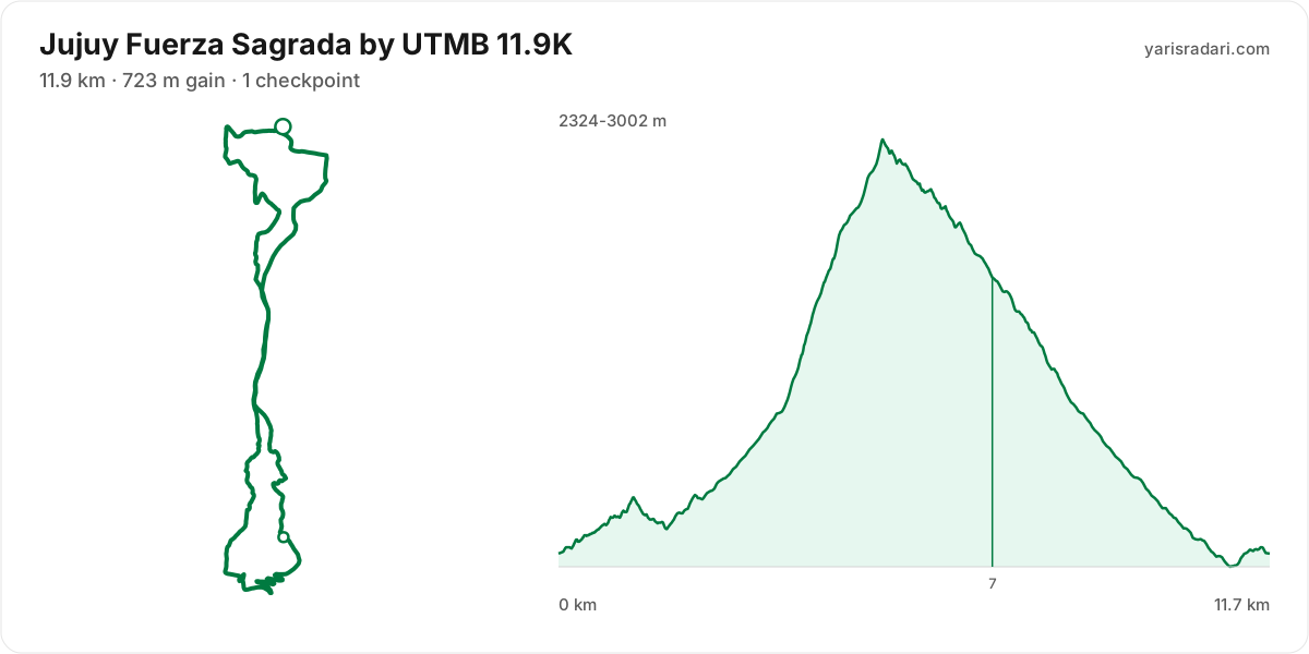
11.9K course12 km · 763 m gain · 45% uphill · 1 aid station
- Steep climb (10%+)
- Climb (3-10%)
- Descent
- Steep descent (12%+)
The published GPX measures 12 km with 763 m of climbing, 65 m per km. The course sits between 2324 m and 3002 m of altitude. 94% of the gain sits in the first half.
The race climbs from the gun: 56 m over the first 1.5 km. Do not chase the crowd, the two minutes you win here get taken back with interest.
The backbone of the course runs from km 0 to km 5: 645 m over 5.3 km at 12% average, its steepest roughly 250 m section averaging 32% on the GPX trace. It tops out at 2990 m. Kilometre by kilometre: km 1 60 m, km 2 58 m, km 3 88 m, km 4 171 m, km 5 254 m. Running is off the table only in the steepest roughly 250 m core; hike that part with short steps and run again once the grade eases.
The longest descent starts at km 5 and loses 665 m by km 11 at 11% average, its steepest roughly 250 m section averaging 21%. Its length can load the quads, so begin under control and build rhythm only when the ground and visibility allow it.
The last 2 km drop 102 m. If anything is left in your legs, spend it here.
- This course reaches 3002 m. At the high-point coordinate, the same week historically ran 7°C to 15°C. Typical daily maximum wind was 11 km/h, reaching 17 km/h in the sample. This is climate history, not the race-day forecast; keep the shell accessible if race week looks similar.
- Sunset is 19:17, 10 hours 17 minutes after the gun. If your target time is longer than that, carry a headtorch whether or not the rules demand one.
- Consider bringing poles. The course averages 65 m of gain per km and the longest climb averaging over 5% runs 5.3 km; if you have trained with them and the organiser allows them, use them on the climbs and stow them on runnable ground.
- The climbing is stacked into the first half. Start easy; even with less climbing later, the descents and accumulated fatigue still have to be managed.
- 17% of the course is steep descent. Increase your cadence instead of braking, or your quads go early.
- Arrive early for the altitude. The course tops out at 3002 m, and coming up from sea level on race morning costs you more than any training block gains. Get to the area a few days ahead and let your body adjust.
- The altitude is not a single summit: about 12 km of the course sits above 1800 m, 8.8 km above 2400 m. The longest unbroken stretch up high is 12 km and the high zone spans roughly km 0 to km 12. About 100% of the total climbing happens in that thin air, so recalibrate your effort to the altitude, not the gradient alone.
Course-profile notes are generated from GPX grade data; terrain, rules, aid stations and weather are added only when separately sourced.
Aid stations
- Food is available at EL PASO (km 7). Decide what you need before reaching the table; without a planned special task, collect food and fluids and leave within 60-90 seconds. Finish eating on the next calm, suitable section.
- The heaviest leg runs from PURMAMARCA (km 0) to EL PASO (km 7): 7 km with 754 m of climbing. Treat it as the slowest part of your day and get your food out before it.
- Medical support is available at PURMAMARCA (km 0), EL PASO (km 7), and PURMAMARCA (km 12). If something is wrong with your feet or your stomach, deal with it there rather than pushing on.
| Station | Km | From previous | Supplies | Medical | Crew |
|---|---|---|---|---|---|
| PURMAMARCA | 0 | — | — | Yes | No |
| EL PASO | 7.1 | 7.1 | Food | Yes | No |
| PURMAMARCA | 12 | 4.9 | None | Yes | No |
Aid station details come from the list published by the organiser; confirm them at the official source before race day.
Plan your cutoffs for this course
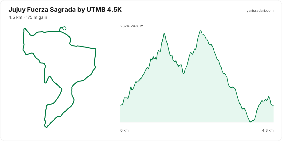
4.5K course4 km · 176 m gain · 53% uphill
- Climb (3-10%)
- Descent
The published GPX measures 4.3 km with 176 m of climbing, 41 m per km. The course sits between 2324 m and 2438 m of altitude.
The longest descent starts at km 2 and loses 108 m by km 4 at 7% average, its steepest roughly 250 m section averaging 10%. Its length can load the quads, so begin under control and build rhythm only when the ground and visibility allow it.
- Sunset is 19:17, 9 hours 17 minutes after the gun. If your target time is longer than that, carry a headtorch whether or not the rules demand one.
- Arrive early for the altitude. The course tops out at 2438 m, and coming up from sea level on race morning costs you more than any training block gains. Get to the area a few days ahead and let your body adjust.
- The altitude is not a single summit: about 4.3 km of the course sits above 1800 m, 1.4 km above 2400 m. The longest unbroken stretch up high is 4.3 km and the high zone spans roughly km 0 to km 4. About 100% of the total climbing happens in that thin air, so recalibrate your effort to the altitude, not the gradient alone.
Course-profile notes are generated from GPX grade data; terrain, rules, aid stations and weather are added only when separately sourced.
Aid stations
- Drinks only, no food, at PURMAMARCA (km 4). Loosen the flask caps on approach; with no queue, refill and leave in 20-30 seconds. Carry the food you will need from the previous station.
- Medical support is available at PURMAMARCA (km 0) and PURMAMARCA (km 4). If something is wrong with your feet or your stomach, deal with it there rather than pushing on.
| Station | Km | From previous | Supplies | Medical | Crew |
|---|---|---|---|---|---|
| PURMAMARCA | 0 | — | — | Yes | No |
| PURMAMARCA | 4.4 | 4.4 | Drinks | Yes | No |
Aid station details come from the list published by the organiser; confirm them at the official source before race day.
Plan your cutoffs for this course
Calculators for this race
Data sources: UTMB World Series, official site (jujuy.utmb.world) · Last checked:
Similar races
Frequently asked questions
(29)
When is Jujuy Fuerza Sagrada by UTMB 2027?
Jujuy Fuerza Sagrada by UTMB takes place on Wed, Mar 31, 2027 - Sun, Apr 4, 2027.
Where does Jujuy Fuerza Sagrada by UTMB take place?
Jujuy Fuerza Sagrada by UTMB takes place in Jujuy, Argentina.
What are the courses and distances of Jujuy Fuerza Sagrada by UTMB 2027?
Jujuy Fuerza Sagrada by UTMB offers 6 courses: 87.2K (87.2 km, 5101 m D+); 50.3K (50.3 km, 2754 m D+); 34K (34 km, 1826 m D+); 21.3K (21.3 km, 884 m D+); 11.9K (11.9 km, 723 m D+); 4.5K (4.5 km, 175 m D+).
How hard is Jujuy Fuerza Sagrada by UTMB 2027?
Difficulty is measured in km-effort: distance plus ascent divided by 100. The 87.2K course covers 87.2 km with 5101 m of climbing, which is 138 km-effort and falls in ITRA category L. All courses: 87.2K 138 km-effort (L), 50.3K 78 km-effort (M), 34K 52 km-effort (S), 21.3K 30 km-effort (XS), 11.9K 19 km-effort (XXS), 4.5K 6 km-effort (XXS).
What is the official website of Jujuy Fuerza Sagrada by UTMB?
Official website: https://jujuy.utmb.world/
Is the Jujuy Fuerza Sagrada by UTMB 2027 course a loop or an out and back?
The 87.2K course is point to point, finishing 20.3 km from the start; measured from the GPX file it runs 85.6 km. The 50.3K course is point to point, finishing 10 km from the start; measured from the GPX file it runs 49.9 km. The 34K course is point to point, finishing 10 km from the start; measured from the GPX file it runs 33.4 km.
Where is the hardest climb at Jujuy Fuerza Sagrada by UTMB 2027?
The biggest climb on the 87.2K course runs from km 15 to km 24: 9.4 km for 1432 m at 15% average; its steepest roughly 250 m section averages 30%. It tops out at 3829 m.
How high does Jujuy Fuerza Sagrada by UTMB 2027 go?
The 87.2K course runs between 2167 m and 3830 m with 5430 m of total climbing. Coming from sea level, arriving a few days early to acclimatise makes a real difference.
Do you need poles at Jujuy Fuerza Sagrada by UTMB 2027?
The 87.2K course averages 63 m of gain per km with a longest climb of 9.4 km, so poles help noticeably.
Do you need a headtorch at Jujuy Fuerza Sagrada by UTMB 2027?
87.2K: Start 05:00, sunrise 07:30: the first 2 hours 30 minutes are run in the dark. The headtorch goes on your head at the start, not in your pack. Sunset is 19:19, 14 hours 19 minutes after the gun. If your target time is longer than that, carry a headtorch whether or not the rules demand one.
What is the weather like at Jujuy Fuerza Sagrada by UTMB 2027?
Over the last 5 years the same week here measured 10°C to 24°C, with a high of 30°C, a low of 4°C and rain on 23% of days. A real forecast lands about two weeks out.
Where are the aid stations at Jujuy Fuerza Sagrada by UTMB 2027?
The 87.2K course has 8 stations; the first at km 13 and the last at km 83. The longest gap between them is 13 km, between PALETA DEL PINTOR and ABRA.
What is served at the Jujuy Fuerza Sagrada by UTMB 2027 aid stations?
For the 87.2K course: Hot food: EL PASO (67. km).
Is there a drop bag at Jujuy Fuerza Sagrada by UTMB 2027?
Yes. On the 87.2K course the drop bag point is EL PASO (km 67).
What time does Jujuy Fuerza Sagrada by UTMB 2027 start?
Known start times: 87.2K 05:00, 50.3K 07:00, 34K 07:00, 21.3K 07:30, 11.9K 09:00, 4.5K 10:00, local time. Confirm against the organiser's schedule in race week.
Is there a GPX file for Jujuy Fuerza Sagrada by UTMB 2027?
Yes. The GPX files for the 87.2K, 50.3K, 34K, 21.3K, 11.9K, 4.5K courses can be downloaded from the course section on this page, next to the route and grade profile.
Which Jujuy Fuerza Sagrada by UTMB course should you choose?
The shortest option is 4.5K (4.5 km, 175 m D+) and the longest is 87.2K (87.2 km, 5101 m D+). With little trail experience the 4.5K is the safer start; the 87.2K demands an all-day effort and cut-off management.
What are the gradients like at Jujuy Fuerza Sagrada by UTMB 2027?
The 87.2K course averages 63 m of climbing per km, with 5430 m of total ascent and 5591 m of descent. The steepest kilometre averages 30%.
How runnable is the Jujuy Fuerza Sagrada by UTMB 2027 course?
This is not a running course in the classic sense: at 63 m of gain per km it demands long hiking blocks, and walking the steep climbs is part of the strategy.
Where is the steepest part of Jujuy Fuerza Sagrada by UTMB 2027?
The steepest kilometre of the 87.2K course averages 30% and sits inside the climb between km 52 and km 59.
How many climbs does Jujuy Fuerza Sagrada by UTMB 2027 have?
The 87.2K course has 7 distinct climbs. The biggest: km 15-24 (1432 m at 15%); km 52-59 (1016 m at 14%); km 73-80 (743 m at 11%).
Is there a long climb at Jujuy Fuerza Sagrada by UTMB 2027?
Yes. The longest climb runs 9.4 km from km 15, gaining 1432 m at 15% average, topping out at 3829 m.
What are the descents like at Jujuy Fuerza Sagrada by UTMB 2027?
There is 5591 m of descent in total. The longest drop runs 13.4 km between km 59 and km 73, losing 1217 m. About 22% of the course is steep downhill, so the legs need descent training too.
Are there flat sections at Jujuy Fuerza Sagrada by UTMB 2027?
Barely: only about 9% of the course is near flat, so the grade keeps changing.
Is the hard part of Jujuy Fuerza Sagrada by UTMB 2027 early or late?
The climbing is evenly split: 49% of it sits in the first half.
What is the elevation range at Jujuy Fuerza Sagrada by UTMB 2027?
The lowest point of the 87.2K course sits at 2167 m and the highest at 3830 m, a range of 1663 m. Conditions change noticeably between the two, so plan clothing in layers.
Where does Jujuy Fuerza Sagrada by UTMB 2027 reach its high point?
The course tops out at 3830 m, reached around km 24.
Are poles mandatory at Jujuy Fuerza Sagrada by UTMB 2027?
The organiser has not announced a pole requirement. Based on the profile poles help noticeably.
Do you need to carry water at Jujuy Fuerza Sagrada by UTMB 2027?
Yes: the longest stretch without aid on the 87.2K course is 13.4 km, so carrying backup water is essential.