Boréalys Mont-Tremblant by UTMBMont-Tremblant, Canada🇨🇦
Completed

About Boréalys Mont-Tremblant by UTMB 2026
Boréalys Mont-Tremblant by UTMB 2026 was a trail race held from Fri, Aug 14, 2026 to Sun, Aug 16, 2026 in Mont-Tremblant, Canada; the start is at 05:00.
The 2026 edition is over; registration is closed. The next edition is added to the calendar automatically once the organiser announces a date.
Experience Boréalys Mont-Tremblant by UTMB. Conquer Québec’s trails, folklore and mountains in a world-class ultra-trail challenge.
Courses
| Course | Distance | Elevation Gain | Km-effort | Course file |
|---|---|---|---|---|
| 81K | 81 km | 4020 m D+ | 121 | |
| 46.4K | 46.4 km | 2612 m D+ | 73 | GPX |
| 26.6K | 26.6 km | 1645 m D+ | 43 | GPX |
| 14.5K | 14.5 km | 896 m D+ | 23 | |
| 5.8K | 5.8 km | 379 m D+ | 10 |
There are 5 courses: 81K (4020 m D+); 46.4K (2612 m D+); 26.6K (1645 m D+); 14.5K (896 m D+); 5.8K (379 m D+).
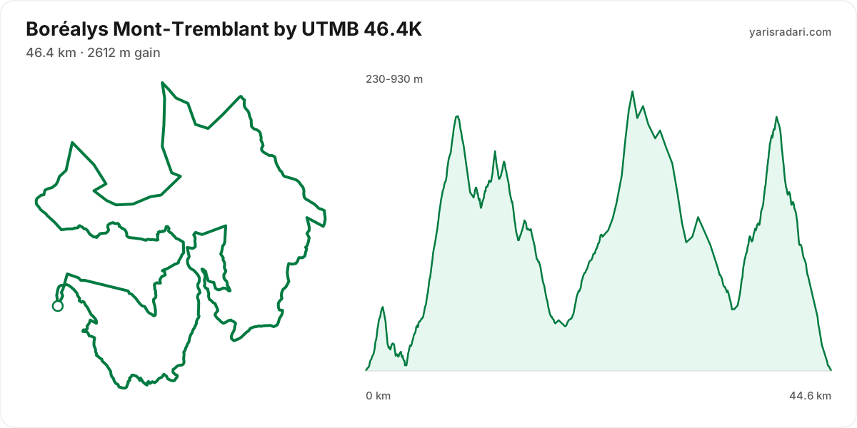
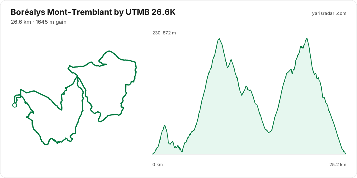
Course map and elevation profile
What the weather was on race day
- On race day the temperature ran 11°C to 21°C, and the day stayed dry, peak wind 16 km/h (a light breeze).
- These figures come from the measurement archive after the race, not from a forecast.
- Sunrise 05:56, sunset 20:09. You start in the dark, so a headtorch is not optional.
The race is over. These figures come from the Open-Meteo measurement archive for that day, not from a forecast.
Race briefing
46.4K course45 km · 2549 m gain · 40% uphill
- Steep climb (10%+)
- Climb (3-10%)
- Flat
- Descent
- Steep descent (12%+)
The published GPX measures 45 km with 2549 m of climbing, 57 m per km. The course sits between 230 m and 931 m of altitude. 55% of the gain sits in the first half.
- 0-3.8 km: 220 m up / 206 m down; the stretch keeps rolling.
- 3.8-8.8 km: 650 m up / 27 m down; the stretch climbs.
- 8.8-19 km: 311 m up / 836 m down; the stretch descends.
- 19-25 km: 586 m up / 15 m down; the stretch climbs.
- 25-39 km: 757 m up / 800 m down; the stretch keeps rolling.
- 39-45 km: 23 m up / 660 m down; the stretch descends.
The first 3.6 km climb 216 m and then drop 181 m. Do not attack the opening climb in the crowd, and do not brake your way down the drop behind it.
The backbone of the course runs from km 4 to km 9: 623 m over 5 km at 12% average, its steepest roughly 250 m section averaging 20%. Kilometre by kilometre: km 5 89 m, km 6 99 m, km 7 178 m, km 8 148 m, km 9 111 m. This is hiking terrain, not running terrain. Walk it with intent and keep your heart rate off the ceiling.
The steepest wall stands between km 19 and km 25: 571 m over 6.2 km at 9% average, its steepest roughly 250 m section averaging 26%. Kilometre by kilometre: km 20 46 m, km 21 87 m, km 22 52 m, km 23 63 m, km 24 73 m, km 25 187 m. By the time you start it, about 46% of the day's climbing is behind you. Trying to run this costs far more than it saves. Shorten the stride, lean on the poles, keep moving.
The late climb from km 35 to km 39: 484 m over 4 km at 12% average, its steepest roughly 250 m section averaging 24%. Kilometre by kilometre: km 36 79 m, km 37 116 m, km 38 99 m, km 39 197 m. By the time you start it, about 78% of the day's climbing is behind you. At this point in the day most runners walk this gradient. Settle into a hiking rhythm and let the metres come.
The longest descent starts at km 26 and loses 529 m by km 35 at 6% average, its steepest roughly 250 m section averaging 19%. Its length can load the quads, so begin under control and build rhythm only when the ground and visibility allow it. The drop at km 39 averages 26% over its steepest roughly 250 m section; shorten the stride, stay balanced and set speed to the ground instead of braking continuously.
The last 5.3 km drop 606 m. If anything is left in your legs, spend it here.
- The organiser lists 46.4 km; the published GPX measures 44.6 km. The technical course notes use the published GPX measurement.
- This course reaches 931 m. A separate forecast for the high-point coordinate gives 7°C to 17°C, wind up to 15 km/h (a light breeze). It is a daily forecast for that coordinate, so arrival time can still change what you encounter.
- Poles are strongly recommended for this profile. The course averages 57 m of gain per km and the longest climb averaging over 5% runs 6.2 km; if you have trained with them and the organiser allows them, use them on the climbs and stow them on runnable ground.
- 19% of the course is steep descent. Increase your cadence instead of braking, or your quads go early.
Course-profile notes are generated from GPX grade data; terrain, rules, aid stations and weather are added only when separately sourced.
26.6K course25 km · 1601 m gain · 60% uphill
- Steep climb (10%+)
- Climb (3-10%)
- Flat
- Descent
- Steep descent (12%+)
The published GPX measures 25 km with 1601 m of climbing, 63 m per km. The course sits between 230 m and 872 m of altitude. 60% of the gain sits in the first half.
- 0-3.8 km: 209 m up / 195 m down; the stretch keeps rolling.
- 3.8-8.8 km: 647 m up / 24 m down; the stretch climbs.
- 8.8-15 km: 115 m up / 632 m down; the stretch descends.
- 15-20 km: 608 m up / 88 m down; the stretch climbs.
- 20-25 km: 23 m up / 660 m down; the stretch descends.
The race climbs from the gun: 89 m over the first 2 km. Do not chase the crowd, the two minutes you win here get taken back with interest.
The backbone of the course runs from km 4 to km 9: 623 m over 5 km at 12% average, its steepest roughly 250 m section averaging 20%. Kilometre by kilometre: km 5 93 m, km 6 99 m, km 7 175 m, km 8 148 m, km 9 107 m. This is hiking terrain, not running terrain. Walk it with intent and keep your heart rate off the ceiling.
The steepest wall stands between km 15 and km 20: net 519 m over 5.1 km at 10% average, its steepest roughly 250 m section averaging 20%, 607 m of climbing in total with 88 m given back. Kilometre by kilometre: km 16 88 m, km 17 165 m, km 18 113 m, km 19 114 m, km 20 116 m. Trying to run this costs far more than it saves. Shorten the stride, lean on the poles, keep moving.
The longest descent starts at km 9 and loses 517 m by km 15 at 8% average, its steepest roughly 250 m section averaging 22%. Its length can load the quads, so begin under control and build rhythm only when the ground and visibility allow it. The drop at km 20 averages 29% over its steepest roughly 250 m section; shorten the stride, stay balanced and set speed to the ground instead of braking continuously.
The last 3 km drop 314 m. If anything is left in your legs, spend it here.
- The organiser lists 26.6 km; the published GPX measures 25.2 km. The technical course notes use the published GPX measurement.
- This course reaches 872 m. A separate forecast for the high-point coordinate gives 8°C to 17°C, wind up to 15 km/h (a light breeze). It is a daily forecast for that coordinate, so arrival time can still change what you encounter.
- Poles are strongly recommended for this profile. The course averages 63 m of gain per km and the longest climb averaging over 5% runs 5.1 km; if you have trained with them and the organiser allows them, use them on the climbs and stow them on runnable ground.
- The climbing is stacked into the first half. Start easy; even with less climbing later, the descents and accumulated fatigue still have to be managed.
- 17% of the course is steep descent. Increase your cadence instead of braking, or your quads go early.
Course-profile notes are generated from GPX grade data; terrain, rules, aid stations and weather are added only when separately sourced.
Calculators for this race
Registration
- StandardTue, Sep 16, 2025 - Fri, Jul 24, 2026Entries closed
Data sources: UTMB World Series, official site (borealys.utmb.world) · Last checked:
Similar races
Frequently asked questions
(28)
What is Boréalys Mont-Tremblant by UTMB?
Experience Boréalys Mont-Tremblant by UTMB. Conquer Québec’s trails, folklore and mountains in a world-class ultra-trail challenge.
When is Boréalys Mont-Tremblant by UTMB 2026?
Boréalys Mont-Tremblant by UTMB takes place on Fri, Aug 14, 2026 - Sun, Aug 16, 2026. Start time: 05:00.
Where does Boréalys Mont-Tremblant by UTMB take place?
Boréalys Mont-Tremblant by UTMB takes place in Mont-Tremblant, Canada.
What are the courses and distances of Boréalys Mont-Tremblant by UTMB 2026?
Boréalys Mont-Tremblant by UTMB offers 5 courses: 81K (81 km, 4020 m D+); 46.4K (46.4 km, 2612 m D+); 26.6K (26.6 km, 1645 m D+); 14.5K (14.5 km, 896 m D+); 5.8K (5.8 km, 379 m D+).
How hard is Boréalys Mont-Tremblant by UTMB 2026?
Difficulty is measured in km-effort: distance plus ascent divided by 100. The 81K course covers 81 km with 4020 m of climbing, which is 121 km-effort and falls in ITRA category L. All courses: 81K 121 km-effort (L), 46.4K 73 km-effort (S), 26.6K 43 km-effort (XS), 14.5K 23 km-effort (XXS), 5.8K 10 km-effort (XXS).
Is registration for Boréalys Mont-Tremblant by UTMB 2026 open?
The 2026 edition has taken place; registration is closed. Follow the official site and Yarış Radarı for the next edition: https://yarisradari.com/en/yaris/borealys-mont-tremblant-by-utmb
Where are the Boréalys Mont-Tremblant by UTMB 2026 results?
The Boréalys Mont-Tremblant by UTMB 2026 result list is published by the organiser at: https://live.utmb.world/borealys/2026
What is the official website of Boréalys Mont-Tremblant by UTMB?
Official website: https://borealys.utmb.world/
Is the Boréalys Mont-Tremblant by UTMB 2026 course a loop or an out and back?
The 46.4K course is a single loop with a shared start and finish; measured from the GPX file it runs 44.6 km. The 26.6K course is a single loop with a shared start and finish; measured from the GPX file it runs 25.2 km.
Where is the hardest climb at Boréalys Mont-Tremblant by UTMB 2026?
The biggest climb on the 46.4K course runs from km 4 to km 9: 5 km for 623 m at 12% average; its steepest roughly 250 m section averages 20%. It tops out at 867 m.
How high does Boréalys Mont-Tremblant by UTMB 2026 go?
The 46.4K course runs between 230 m and 931 m with 2549 m of total climbing.
Do you need poles at Boréalys Mont-Tremblant by UTMB 2026?
The 46.4K course averages 57 m of gain per km with a longest climb of 6.2 km, so poles help noticeably.
What was the weather like at Boréalys Mont-Tremblant by UTMB 2026?
On race day the temperature ran 11°C to 21°C, and the day stayed dry, peak wind 16 km/h. These figures come from the measurement archive.
Is there a GPX file for Boréalys Mont-Tremblant by UTMB 2026?
Yes. The GPX files for the 46.4K, 26.6K courses can be downloaded from the course section on this page, next to the route and grade profile.
Which Boréalys Mont-Tremblant by UTMB course should you choose?
The shortest option is 5.8K (5.8 km, 379 m D+) and the longest is 81K (81 km, 4020 m D+). With little trail experience the 5.8K is the safer start; the 81K demands an all-day effort and cut-off management.
What are the gradients like at Boréalys Mont-Tremblant by UTMB 2026?
The 46.4K course averages 57 m of climbing per km, with 2549 m of total ascent and 2544 m of descent. The steepest kilometre averages 21%.
How runnable is the Boréalys Mont-Tremblant by UTMB 2026 course?
This is not a running course in the classic sense: at 57 m of gain per km it demands long hiking blocks, and walking the steep climbs is part of the strategy.
Where is the steepest part of Boréalys Mont-Tremblant by UTMB 2026?
The steepest kilometre of the 46.4K course averages 21% and sits inside the climb between km 19 and km 25.
How many climbs does Boréalys Mont-Tremblant by UTMB 2026 have?
The 46.4K course has 6 distinct climbs. The biggest: km 4-9 (623 m at 12%); km 19-25 (571 m at 9%); km 35-39 (484 m at 12%).
Is there a long climb at Boréalys Mont-Tremblant by UTMB 2026?
Yes. The longest climb runs 6.2 km from km 19, gaining 571 m at 9% average, topping out at 913 m.
What are the descents like at Boréalys Mont-Tremblant by UTMB 2026?
There is 2544 m of descent in total. The longest drop runs 9.5 km between km 26 and km 35, losing 529 m. About 19% of the course is steep downhill, so the legs need descent training too.
Are there flat sections at Boréalys Mont-Tremblant by UTMB 2026?
Barely: only about 9% of the course is near flat, so the grade keeps changing.
Is the hard part of Boréalys Mont-Tremblant by UTMB 2026 early or late?
The climbing is evenly split: 55% of it sits in the first half.
What is the elevation range at Boréalys Mont-Tremblant by UTMB 2026?
The lowest point of the 46.4K course sits at 230 m and the highest at 931 m, a range of 701 m.
Where does Boréalys Mont-Tremblant by UTMB 2026 reach its high point?
The course tops out at 931 m, reached around km 25.
Are poles mandatory at Boréalys Mont-Tremblant by UTMB 2026?
The organiser has not announced a pole requirement. Based on the profile poles help noticeably.
When is Boréalys Mont-Tremblant by UTMB 2027?
The date for Boréalys Mont-Tremblant by UTMB 2027 has not been announced yet. It will appear on this page once the organiser confirms it: https://yarisradari.com/en/yaris/borealys-mont-tremblant-by-utmb
Will Boréalys Mont-Tremblant by UTMB 2026 take place?
Boréalys Mont-Tremblant by UTMB status: Completed.