Gauja Trail by UTMBCesis, Latvia🇱🇻
Completed

About Gauja Trail by UTMB 2026
Gauja Trail by UTMB 2026 was a trail race held from Sat, Aug 1, 2026 to Sun, Aug 2, 2026 in Cesis, Latvia.
The 2026 edition is over; registration is closed. The next edition is added to the calendar automatically once the organiser announces a date.
A trail running race held in Cesis, Latvia, in the forests of Gauja National Park. The courses range from a 1.6-kilometre kids' run to a 91-kilometre long distance; climbs remain relatively modest, with 2,200 metres on the longest route. The programme also includes a 21-kilometre Nordic walking category and a 6-kilometre run for young athletes. Featured on the UTMB World Series calendar, the event awards Running Stones points according to distance.
Courses
| Course | Distance | Elevation Gain | Km-effort | Course file |
|---|---|---|---|---|
| 91K | 91 km | 2200 m D+ | 113 | GPX |
| 53K | 53 km | 1200 m D+ | 65 | GPX |
| 21K | 21 km | 500 m D+ | 26 | GPX |
| 13.5K | 13.5 km | 300 m D+ | 17 | GPX |
| 12K | 12 km | 300 m D+ | 15 | |
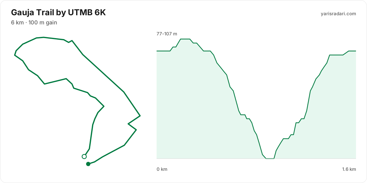
| 6K | 6 km | 100 m D+ | 7 | GPX |
| 1.6K | 1.6 km | 30 m D+ | 2 |
There are 7 courses: 91K (2200 m D+); 53K (1200 m D+); 21K (500 m D+); 13.5K (300 m D+); 12K (300 m D+); 6K (100 m D+); 1.6K (30 m D+).
Course map and elevation profile
What the weather was on race day
- On race day the temperature ran 17°C to 23°C, and the day stayed dry, peak wind 10 km/h (calm).
- These figures come from the measurement archive after the race, not from a forecast.
- Sunrise 05:18, sunset 21:34.
The race is over. These figures come from the Open-Meteo measurement archive for that day, not from a forecast.
Race briefing
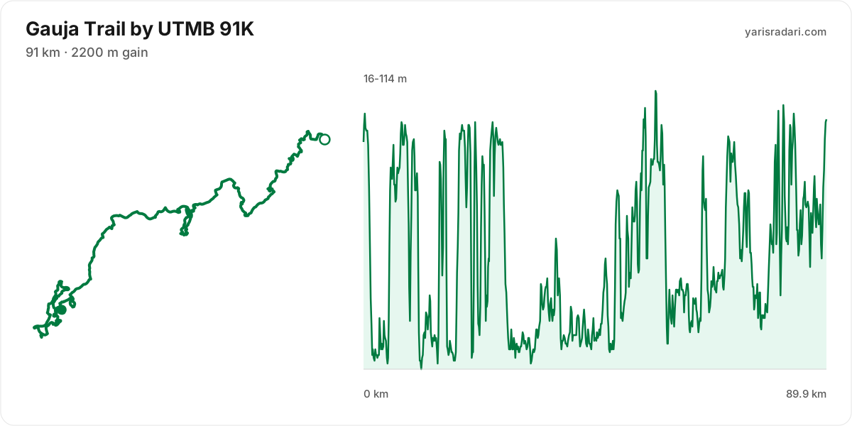
91K course90 km · 1891 m gain · 7% uphill
- Steep climb (10%+)
- Climb (3-10%)
- Flat
- Descent
- Steep descent (12%+)
The published GPX measures 90 km with 1891 m of climbing, 21 m per km. The course sits between 16 m and 114 m of altitude. 47% of the gain sits in the first half.
The first 5 km roll: 73 m up and 121 m down. You will not hold one rhythm here, so treat the early climbs as a warm-up.
There is no single defining climb; the gain is spread across 12 separate hills. A typical hill rises about 60 m and the biggest gains 82 m around km 5. This profile keeps breaking your rhythm, so hold a steady effort on the rises, recover on the drops and switch to hiking without hesitation.
The last 6 km roll: 133 m up and 118 m down. Do not start the finishing effort early, there is another climb in there.
- The organiser lists 91 km; the published GPX measures 89.9 km. The organiser lists 2200 m of climbing; the published GPX measures 1891 m. The technical course notes use the published GPX measurement.
- Poles are optional: 21 m of gain per km. Bring them to protect your legs, not to gain speed.
- Point to point: the finish sits 30.1 km from the start as the crow flies. Sort the shuttle and your drop bag before race day.
Course-profile notes are generated from GPX grade data; terrain, rules, aid stations and weather are added only when separately sourced.
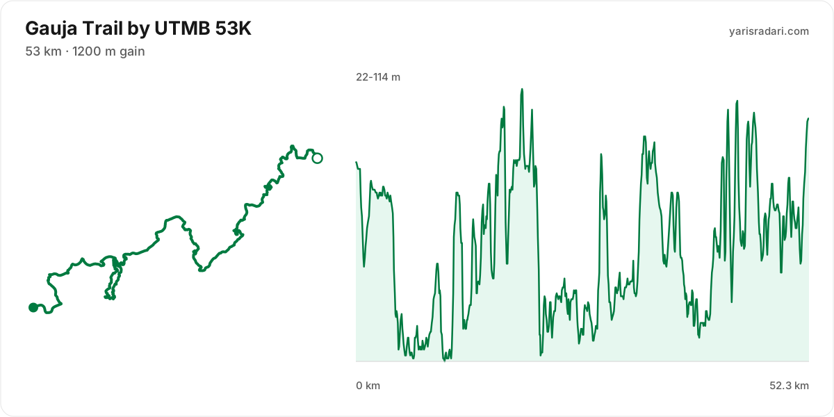
53K course52 km · 1048 m gain · 11% uphill
- Climb (3-10%)
- Flat
- Descent
The published GPX measures 52 km with 1048 m of climbing, 20 m per km. The course sits between 22 m and 114 m of altitude. 41% of the gain sits in the first half.
The first 4.2 km are close to flat, good for settling in. Do not set your pace here, the real course starts after.
There is no single defining climb; the gain is spread across 6 separate hills. A typical hill rises about 50 m and the biggest gains 68 m around km 43. This profile keeps breaking your rhythm, so hold a steady effort on the rises, recover on the drops and switch to hiking without hesitation.
The last 6 km roll: 133 m up and 118 m down. Do not start the finishing effort early, there is another climb in there.
- The organiser lists 53 km; the published GPX measures 52.3 km. The organiser lists 1200 m of climbing; the published GPX measures 1048 m. The technical course notes use the published GPX measurement.
- Poles are optional: 20 m of gain per km. Bring them to protect your legs, not to gain speed.
- Point to point: the finish sits 20.9 km from the start as the crow flies. Sort the shuttle and your drop bag before race day.
Course-profile notes are generated from GPX grade data; terrain, rules, aid stations and weather are added only when separately sourced.
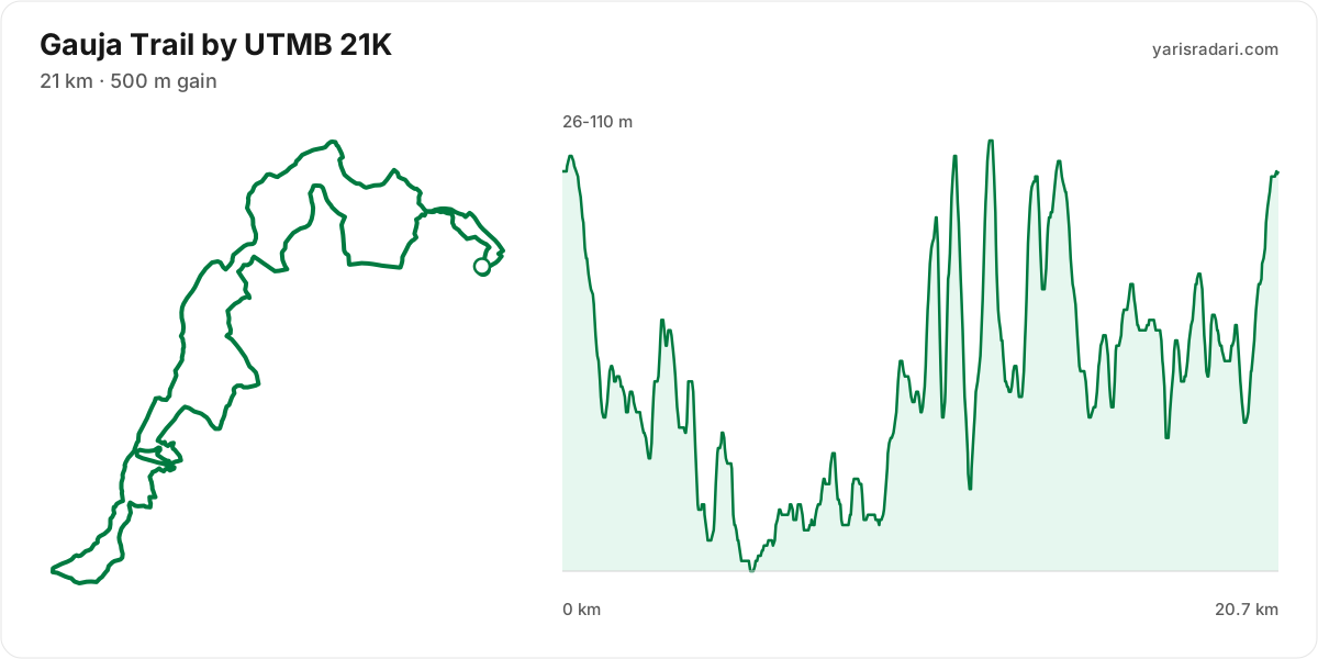
21K course21 km · 489 m gain · 7% uphill
- Climb (3-10%)
- Flat
- Descent
The published GPX measures 21 km with 489 m of climbing, 24 m per km. The course sits between 26 m and 110 m of altitude. 27% of the gain sits in the first half.
The first 1.7 km are close to flat, good for settling in. Do not set your pace here, the real course starts after.
The last 2.5 km climb 29 m to the line. Know it going in and save something for it.
- Poles are optional: 24 m of gain per km. Bring them to protect your legs, not to gain speed.
- Most of the climbing waits in the second half. Feeling good early is a trap here.
Course-profile notes are generated from GPX grade data; terrain, rules, aid stations and weather are added only when separately sourced.
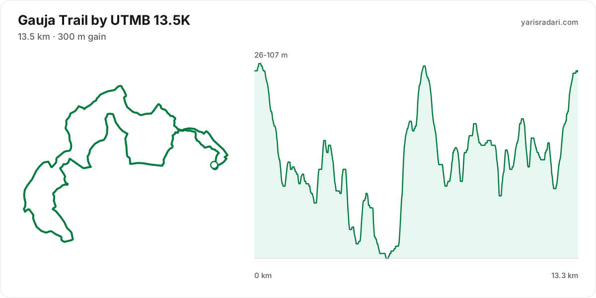
13.5K course13 km · 280 m gain · 6% uphill
- Climb (3-10%)
- Flat
- Descent
The published GPX measures 13 km with 280 m of climbing, 21 m per km. The course sits between 26 m and 107 m of altitude.
The first 1.5 km are close to flat, good for settling in. Do not set your pace here, the real course starts after.
The last 2 km are close to flat. Plan your finishing pace around that, there is nothing left to save.
- Poles are optional: 21 m of gain per km. Bring them to protect your legs, not to gain speed.
Course-profile notes are generated from GPX grade data; terrain, rules, aid stations and weather are added only when separately sourced.
6K course2 km · 28 m gain · 0% uphill
- Flat
The published GPX measures 1.6 km with 28 m of climbing, 18 m per km.
- The organiser lists 6 km; the published GPX measures 1.6 km. The technical course notes use the published GPX measurement.
Course-profile notes are generated from GPX grade data; terrain, rules, aid stations and weather are added only when separately sourced.
Calculators for this race
Data sources: UTMB World Series, official site (gauja.utmb.world) · Last checked:
Similar races
Frequently asked questions
(27)
What is Gauja Trail by UTMB?
A trail running race held in Cesis, Latvia, in the forests of Gauja National Park. The courses range from a 1.6-kilometre kids' run to a 91-kilometre long distance; climbs remain relatively modest, with 2,200 metres on the longest route. The programme also includes a 21-kilometre Nordic walking category and a 6-kilometre run for young athletes. Featured on the UTMB World Series calendar, the event awards Running Stones points according to distance.
When is Gauja Trail by UTMB 2026?
Gauja Trail by UTMB takes place on Sat, Aug 1, 2026 - Sun, Aug 2, 2026.
Where does Gauja Trail by UTMB take place?
Gauja Trail by UTMB takes place in Cesis, Latvia.
What are the courses and distances of Gauja Trail by UTMB 2026?
Gauja Trail by UTMB offers 7 courses: 91K (91 km, 2200 m D+); 53K (53 km, 1200 m D+); 21K (21 km, 500 m D+); 13.5K (13.5 km, 300 m D+); 12K (12 km, 300 m D+); 6K (6 km, 100 m D+); 1.6K (1.6 km, 30 m D+).
How hard is Gauja Trail by UTMB 2026?
Difficulty is measured in km-effort: distance plus ascent divided by 100. The 91K course covers 91 km with 2200 m of climbing, which is 113 km-effort and falls in ITRA category M. All courses: 91K 113 km-effort (M), 53K 65 km-effort (S), 21K 26 km-effort (XS), 13.5K 17 km-effort (XXS), 12K 15 km-effort (XXS), 6K 7 km-effort (XXS), 1.6K 2 km-effort (XXS).
Is registration for Gauja Trail by UTMB 2026 open?
The 2026 edition has taken place; registration is closed. Follow the official site and Yarış Radarı for the next edition: https://yarisradari.com/en/yaris/gauja-trail-by-utmb
Where are the Gauja Trail by UTMB 2026 results?
The Gauja Trail by UTMB 2026 result list is published by the organiser at: https://gauja.utmb.world/results
Where are the Gauja Trail by UTMB photos?
Gauja Trail by UTMB photos are in the organiser's gallery: https://gauja.utmb.world/photos. The gallery may also cover earlier editions.
What is the official website of Gauja Trail by UTMB?
Official website: https://gauja.utmb.world/
Is the Gauja Trail by UTMB 2026 course a loop or an out and back?
The 91K course is point to point, finishing 30.1 km from the start; measured from the GPX file it runs 89.9 km. The 53K course is point to point, finishing 20.9 km from the start; measured from the GPX file it runs 52.3 km. The 21K course is a single loop with a shared start and finish; measured from the GPX file it runs 20.7 km.
Where is the hardest climb at Gauja Trail by UTMB 2026?
The biggest climb on the 91K course runs from km 5 to km 7: 2.6 km for 82 m at 3% average; its steepest roughly 250 m section averages 17%. It tops out at 100 m.
How high does Gauja Trail by UTMB 2026 go?
The 91K course runs between 16 m and 114 m with 1891 m of total climbing.
Do you need poles at Gauja Trail by UTMB 2026?
The 91K course averages 21 m of gain per km. Poles are optional here.
What was the weather like at Gauja Trail by UTMB 2026?
On race day the temperature ran 17°C to 23°C, and the day stayed dry, peak wind 10 km/h. These figures come from the measurement archive.
Is there a GPX file for Gauja Trail by UTMB 2026?
Yes. The GPX files for the 91K, 53K, 21K, 13.5K, 6K courses can be downloaded from the course section on this page, next to the route and grade profile.
Which Gauja Trail by UTMB course should you choose?
The shortest option is 1.6K (1.6 km, 30 m D+) and the longest is 91K (91 km, 2200 m D+). With little trail experience the 1.6K is the safer start; the 91K demands an all-day effort and cut-off management.
What are the gradients like at Gauja Trail by UTMB 2026?
The 91K course averages 21 m of climbing per km, with 1891 m of total ascent and 1884 m of descent. The steepest kilometre averages 26%.
How runnable is the Gauja Trail by UTMB 2026 course?
Expect a mix of running and power hiking: 21 m of gain per km; hiking the long climbs is normal, and the longest climb runs 2.6 km.
Where is the steepest part of Gauja Trail by UTMB 2026?
The steepest kilometre of the 91K course averages 26% and sits inside the climb between km 21 and km 22.
How many climbs does Gauja Trail by UTMB 2026 have?
The 91K course has 12 distinct climbs. The biggest: km 5-7 (82 m at 3%); km 18-19 (79 m at 10%); km 21-22 (71 m at 26%).
Is there a long climb at Gauja Trail by UTMB 2026?
Yes. The longest climb runs 2.6 km from km 5, gaining 82 m at 3% average, topping out at 100 m.
What are the descents like at Gauja Trail by UTMB 2026?
There is 1884 m of descent in total. The longest drop runs 4.2 km between km 0 and km 4, losing 85 m.
Are there flat sections at Gauja Trail by UTMB 2026?
Yes, roughly 79% of the course is near flat, with long sections where a rhythm holds.
Is the hard part of Gauja Trail by UTMB 2026 early or late?
The climbing is evenly split: 47% of it sits in the first half.
Are poles mandatory at Gauja Trail by UTMB 2026?
The organiser has not announced a pole requirement. Based on the profile poles are optional.
When is Gauja Trail by UTMB 2027?
The date for Gauja Trail by UTMB 2027 has not been announced yet. It will appear on this page once the organiser confirms it: https://yarisradari.com/en/yaris/gauja-trail-by-utmb
Will Gauja Trail by UTMB 2026 take place?
Gauja Trail by UTMB status: Completed.