Merrell İstanbul Ultraİstanbul🇹🇷
Completed
About Merrell İstanbul Ultra 2026
Merrell İstanbul Ultra 2026 was a trail race held on Sat, Sep 5, 2026 in İstanbul; the start is at 09:45.
The 2026 edition is over; registration is closed. The next edition is added to the calendar automatically once the organiser announces a date.
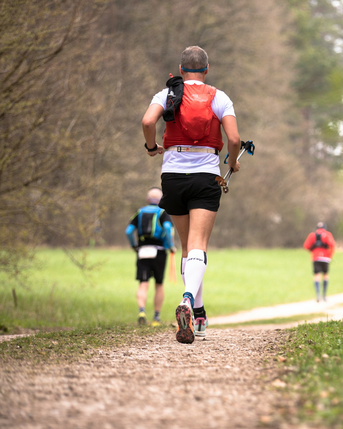
Starting in the heart of the forest, finding its rhythm on the trails of the northern forests, pushing limits on the Black Sea beaches, and amplifying the fun with changing terrain transitions, Merrell İstanbul Ultra takes place on 5 September 2026 at İstanbul Kemerburgaz Kent Ormanı!
Courses
| Course | Distance | Elevation Gain | Km-effort | Course file |
|---|---|---|---|---|
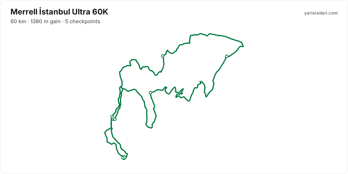
| 60K | 60 km | 1380 m D+ | 74 | GPX |
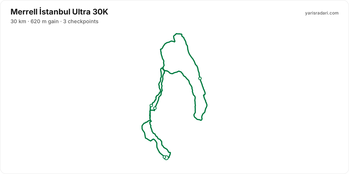
| 30K | 30 km | 620 m D+ | 36 | GPX |
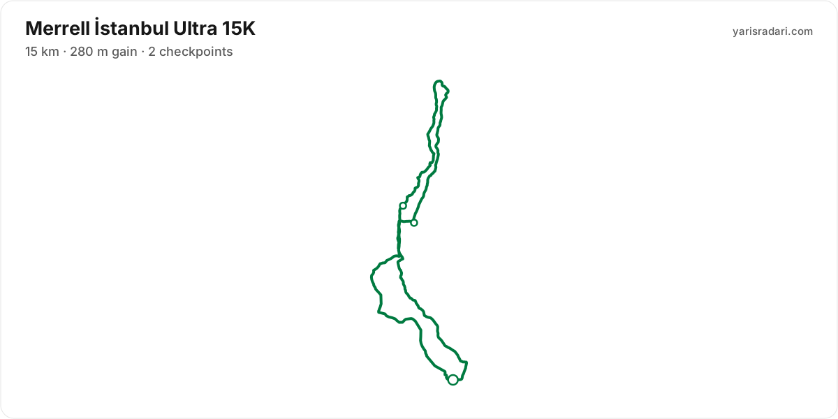
| 15K | 15 km | 280 m D+ | 18 | GPX |
| 5K | 5 km | 113 m D+ | 6 | GPX |
There are 4 courses: 60K (1380 m D+); 30K (620 m D+); 15K (280 m D+); 5K (113 m D+).
Course map and elevation profile
What the weather was on race day
- On race day the temperature ran 19°C to 29°C, and the day stayed dry, peak wind 15 km/h (a light breeze).
- These figures come from the measurement archive after the race, not from a forecast.
- Sunrise 06:34, sunset 19:31.
The race is over. These figures come from the Open-Meteo measurement archive for that day, not from a forecast.
Race briefing
60K course59 km · 1063 m gain · 5 aid stations
The station table gives 59 km with 1063 m of climbing, 18 m per km. The same table lists 1063 m of descent. By leg totals, roughly 49% of the gain sits in the first half.
Leg by leg: the first 4.5 km for 90 m (CP1 - Göktürk), the next 12 km for 150 m (CP2 - Macera Parkı), the next 16 km for 332 m (CP3 - Gümüşdere), the next 11 km for 207 m (CP4 - Taşlı Yokuş), the next 11 km for 163 m (CP5 - Bent), the last 5 km for 121 m.
The steepest leg is the last one: 5 km for 121 m, 24 m per km, 34% above the course average. Constant uphill without being steep, the kind of grade that quietly eats your pace.
These are leg totals. The table does not say where inside a leg the climbing sits, so the steep parts of a leg will be harder than its average.
- The organiser lists 1380 m of climbing; the aid-station legs add up to 1063 m. The course notes use the GPX for route shape and the aid-station table for climbing.
- Even at cut-off pace you finish 2 hours 1 minute before sunset. This one is run entirely in daylight.
- Organiser rule: Athletes who start with poles must finish the race with them. Otherwise, a +60-minute time penalty applies.
- Poles are optional: 18 m of gain per km. Bring them to protect your legs, not to gain speed.
The organiser's GPX file has no elevation data, so the grade profile and kilometre analysis cannot be shown for this course; climb figures come from the aid station table.
Aid stations
Key decision points
CP2 - Macera Parkıkm 16
- Collect food and fluids and leave within 60-90 seconds.
- The heaviest leg is next: 16 km with 332 m of climbing.
- The longest unsupported stretch starts here: 16 km. Leave with full capacity.
- Cut-off: 3h after the start.
- The longest stretch between official aid stations runs from CP2 - Macera Parkı (km 16) to CP3 - Gümüşdere (km 32): 16 km, with 332 m of climbing in between. Top up at CP2 - Macera Parkı and size what you carry to the expected duration and your own drinking rate.
- Food is available at CP1 - Göktürk (km 5) and CP2 - Macera Parkı (km 16) and 3 more. Decide what you need before reaching the table; without a planned special task, collect food and fluids and leave within 60-90 seconds. Finish eating on the next calm, suitable section.
- The last aid station is CP5 - Bent (km 54), leaving 6 km to the finish. After that you are on what you carry.
- The overall cut-off is 11h, including all checkpoint stops. Build the plan around the official leg budgets below, not a flat-course average pace.
- Relative to distance and climbing, the tightest official time budget runs from CP2 - Macera Parkı (km 16) to CP3 - Gümüşdere (km 32): the official time budget is 3h for 16 km and 332 m of climbing. Station stops come out of that same budget, so do not enter the leg already behind schedule.
| Station | Km | From previous | Supplies | Cut-off |
|---|---|---|---|---|
| CP1 - Göktürk | 4.5 | 4.5 | Food | — |
| CP2 - Macera Parkı | 16 | 12 | Food | 3h |
| CP3 - Gümüşdere | 32 | 16 | Food | 6h |
| CP4 - Taşlı Yokuş | 43 | 11 | Food | — |
| CP5 - Bent | 54 | 11 | Food | — |
| Finish | 59 | 5 | — | 11h |
Aid station details come from the list published by the organiser; confirm them at the official source before race day.
30K course31 km · 481 m gain · 3 aid stations
The station table gives 31 km with 481 m of climbing, 16 m per km. The same table lists 481 m of descent. By leg totals, roughly 48% of the gain sits in the first half.
Leg by leg: the first 4.5 km for 90 m (CP1 - Göktürk), the next 12 km for 150 m (CP2 - Macera Parkı), the next 9.6 km for 129 m (CP3 - Bent), the last 5 km for 112 m.
The steepest leg is the last one: 5 km for 112 m, 22 m per km, 40% above the course average. Constant uphill without being steep, the kind of grade that quietly eats your pace.
These are leg totals. The table does not say where inside a leg the climbing sits, so the steep parts of a leg will be harder than its average.
km 0-2.9 (in rain) · The wide road turns muddy in rain
The wide forest road of the opening turns muddy in rain; pick shoes and opening pace accordingly.
km 0-2.9 · Climbing opening on wide forest road
The first 3 km run on wide, easy forest road with a climbing bias. The wide road invites speed; settle your rhythm without exceeding your target effort.
km 2.9 · Right turn onto the trail
At km 2.9 the route turns right off the wide road onto a trail. Do not just follow the runner ahead; see the marking yourself.
km 2.9-3.3 · Roughly 400 m of semi-technical descent
Right after the trail entry comes roughly 400 m of semi-technical descent; shorten your stride and hold your place in the line.
km 3.3-4.4 · About 1.1 km of asphalt after the descent
After the semi-technical descent comes about 1.1 km of asphalt; use it to let your legs recover.
km 4.4 · Junction onto the lakeside trail
After the asphalt a short climb links onto the lakeside single-track; a fast, single-file line up to the Göktürk station.
km 4.5-6 · A 1.5 km climb after Göktürk
Leaving the Göktürk station there is about 1.5 km of forest-road climbing around 6%; do not enter it cooled down from the stop.
km 6-10 · Rolling but descent-biased 4 km
After the climb come roughly 4 km of rolling but descent-biased forest roads; gather your rhythm here.
km 13-16 · Through the historic dams and the Adventure Park
Between km 13 and 16 the route passes the historic dams and the Adventure Park; easy, wide forest road follows.
km 16-19 · Narrower but still flowing
After km 16 the way narrows but stays flowing; you can keep your pace.
km 19-22 · The climb at km 19 and the effort wave after it
The roughly 600 m trail climb at km 19 is followed by about 2 km of descent and a second 500 m rise. Make your food reachable before the climb and be ready for the effort swings.
km 22-26 · Fast, descent-biased forest road
The next roughly 4 km are fast, descent-biased forest road; this is where you can speed up under control.
km 27-31 · The last four kilometres run the start route in reverse
The final four kilometres run the opening route in reverse; the ground is familiar, but watch the direction changes.
km 27 · A 700 m climb inside the last 4 km
Early in the last four kilometres sits a roughly 700 m climb of moderate steepness; past it, the final 3 km are a fast, descent-biased finish.
- The organiser lists 30 km; the published GPX measures 30.9 km. The organiser lists 620 m of climbing; the aid-station legs add up to 481 m. The course notes use the GPX for route shape and the aid-station table for climbing.
- Even at cut-off pace you finish 5 hours 31 minutes before sunset. This one is run entirely in daylight.
- Organiser rule: Athletes who start with poles must finish the race with them. Otherwise, a +60-minute time penalty applies.
- Poles are optional: 16 m of gain per km. Bring them to protect your legs, not to gain speed.
The organiser's GPX file has no elevation data, so the grade profile and kilometre analysis cannot be shown for this course; climb figures come from the aid station table.
Aid stations
- The longest stretch between official aid stations runs from CP1 - Göktürk (km 5) to CP2 - Macera Parkı (km 16): 12 km, with 150 m of climbing in between. Top up at CP1 - Göktürk and size what you carry to the expected duration and your own drinking rate.
- Food is available at CP1 - Göktürk (km 5) and CP2 - Macera Parkı (km 16) and 1 more. Decide what you need before reaching the table; without a planned special task, collect food and fluids and leave within 60-90 seconds. Finish eating on the next calm, suitable section.
- The overall cut-off is 6h, including all checkpoint stops. Build the plan around the official leg budgets below, not a flat-course average pace.
- Relative to distance and climbing, the tightest official time budget runs from Start to CP2 - Macera Parkı (km 16): the official time budget is 3h for 16 km and 240 m of climbing. Station stops come out of that same budget, so do not enter the leg already behind schedule.
| Station | Km | From previous | Supplies | Cut-off |
|---|---|---|---|---|
| CP1 - Göktürk | 4.5 | 4.5 | Food | — |
| CP2 - Macera Parkı | 16 | 12 | Food | 3h |
| CP3 - Bent | 26 | 9.6 | Food | — |
| Finish | 31 | 5 | — | 6h |
Aid station details come from the list published by the organiser; confirm them at the official source before race day.
15K course16 km · 263 m gain · 2 aid stations
The station table gives 16 km with 263 m of climbing, 17 m per km. The same table lists 263 m of descent. By leg totals, roughly 47% of the gain sits in the first half.
Leg by leg: the first 4.5 km for 90 m (CP1 - Göktürk), the next 6.1 km for 61 m (CP2 - Bent), the last 5 km for 112 m.
The steepest leg is the last one: 5 km for 112 m, 22 m per km, 32% above the course average. Constant uphill without being steep, the kind of grade that quietly eats your pace.
These are leg totals. The table does not say where inside a leg the climbing sits, so the steep parts of a leg will be harder than its average.
- The organiser lists 15 km; the published GPX measures 15.6 km. The course notes use the GPX for route shape and the aid-station table for climbing.
- Even at cut-off pace you finish 7 hours 16 minutes before sunset. This one is run entirely in daylight.
- Organiser rule: Athletes who start with poles must finish the race with them. Otherwise, a +60-minute time penalty applies.
- Poles are optional: 17 m of gain per km. Bring them to protect your legs, not to gain speed.
- The file measures 15.6 km against the advertised 15 km, so expect your watch to disagree with the signs.
The organiser's GPX file has no elevation data, so the grade profile and kilometre analysis cannot be shown for this course; climb figures come from the aid station table.
Aid stations
- Food is available at CP1 - Göktürk (km 5). Decide what you need before reaching the table; without a planned special task, collect food and fluids and leave within 60-90 seconds. Finish eating on the next calm, suitable section.
- The last aid station is CP1 - Göktürk (km 5), leaving 11 km to the finish. After that you are on what you carry.
- The overall cut-off is 3h, including all checkpoint stops. Build the plan around the official leg budgets below, not a flat-course average pace.
| Station | Km | From previous | Supplies | Cut-off |
|---|---|---|---|---|
| CP1 - Göktürk | 4.5 | 4.5 | Food | — |
| CP2 - Bent | 11 | 6.1 | — | — |
| Finish | 16 | 5 | — | 3h |
Aid station details come from the list published by the organiser; confirm them at the official source before race day.
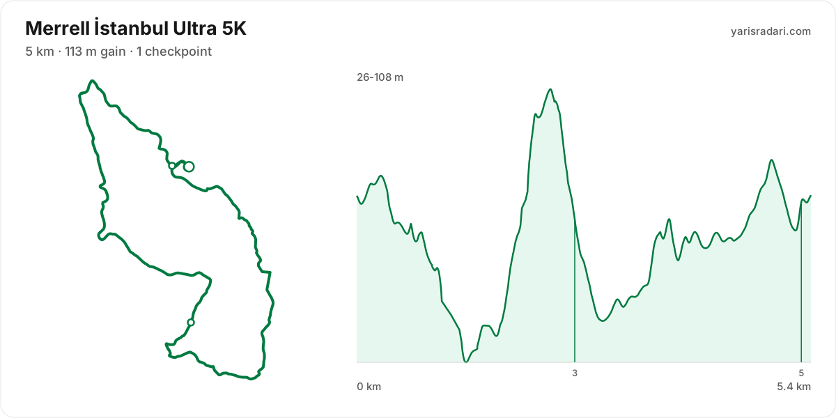
5K course5 km · 145 m gain · 54% uphill · 1 aid station
- Steep climb (10%+)
- Climb (3-10%)
- Flat
- Descent
The published GPX measures 5.4 km with 145 m of climbing, 27 m per km. The course sits between 26 m and 108 m of altitude.
The first 1.5 km are close to flat, good for settling in. Do not set your pace here, the real course starts after.
The last 2 km are close to flat. Plan your finishing pace around that, there is nothing left to save.
- Sunset is 19:31, 9 hours 46 minutes after the gun. If your target time is longer than that, carry a headtorch whether or not the rules demand one.
- Organiser rule: Athletes who start with poles must finish the race with them. Otherwise, a +60-minute time penalty applies.
Course-profile notes are generated from GPX grade data; terrain, rules, aid stations and weather are added only when separately sourced.
Aid stations
- Drinks only, no food, at CP1 - Su Noktası (km 3). Loosen the flask caps on approach; with no queue, refill and leave in 20-30 seconds. Carry the food you will need from the previous station.
| Station | Km | From previous | Supplies |
|---|---|---|---|
| CP1 - Su Noktası | 2.6 | 2.6 | Water |
| Finish | 5.3 | 2.7 | None |
Aid station details come from the list published by the organiser; confirm them at the official source before race day.
Calculators for this race
Registration
- StandardFri, Jan 9, 2026 - Tue, Sep 1, 2026Entries closed
Data sources: PassTiming race calendar, TAF private road races, official site (istanbulultra.com.tr) · Last checked:
Organising this race? See how to correct details and complete this page
Similar races
Frequently asked questions
(33)
What is Merrell İstanbul Ultra?
Starting in the heart of the forest, finding its rhythm on the trails of the northern forests, pushing limits on the Black Sea beaches, and amplifying the fun with changing terrain transitions, Merrell İstanbul Ultra takes place on 5 September 2026 at İstanbul Kemerburgaz Kent Ormanı!
When is Merrell İstanbul Ultra 2026?
Merrell İstanbul Ultra takes place on Sat, Sep 5, 2026. Start time: 09:45.
Where does Merrell İstanbul Ultra take place?
Merrell İstanbul Ultra takes place in İstanbul.
What are the courses and distances of Merrell İstanbul Ultra 2026?
Merrell İstanbul Ultra offers 4 courses: 60K (60 km, 1380 m D+); 30K (30 km, 620 m D+); 15K (15 km, 280 m D+); 5K (5 km, 113 m D+).
How hard is Merrell İstanbul Ultra 2026?
Difficulty is measured in km-effort: distance plus ascent divided by 100. The 60K course covers 60 km with 1380 m of climbing, which is 74 km-effort and falls in ITRA category S. All courses: 60K 74 km-effort (S), 30K 36 km-effort (XS), 15K 18 km-effort (XXS), 5K 6 km-effort (XXS).
Is registration for Merrell İstanbul Ultra 2026 open?
The 2026 edition has taken place; registration is closed. Follow the official site and Yarış Radarı for the next edition: https://yarisradari.com/en/yaris/istanbul-ultra
Where are the Merrell İstanbul Ultra 2026 results?
The Merrell İstanbul Ultra 2026 result list is published by the organiser at: https://etaptiming.com/sonuclar?search=MERRELL
Where are the Merrell İstanbul Ultra photos?
Merrell İstanbul Ultra photos are in the organiser's gallery: https://istanbulultra.com.tr/tr/galeri/2025. The gallery may also cover earlier editions.
What is the official website of Merrell İstanbul Ultra?
Official website: https://istanbulultra.com.tr/
Is a medical certificate required for Merrell İstanbul Ultra?
Yes, a medical certificate is required. See the organiser's official page for the exact wording.
Is the Merrell İstanbul Ultra 2026 course a loop or an out and back?
The 60K course is a single loop with a shared start and finish; measured from the GPX file it runs 59.4 km. The 30K course is a single loop with a shared start and finish; measured from the GPX file it runs 30.9 km. The 15K course is a single loop with a shared start and finish; measured from the GPX file it runs 15.6 km.
Where is the hardest climb at Merrell İstanbul Ultra 2026?
The biggest climb on the 5K course runs from km 2 to km 2: 0.8 km for 68 m at 9% average; its steepest roughly 250 m section averages 12%. It tops out at 103 m.
How high does Merrell İstanbul Ultra 2026 go?
The 5K course runs between 26 m and 108 m with 145 m of total climbing.
Do you need poles at Merrell İstanbul Ultra 2026?
The 5K course averages 27 m of gain per km. Poles are optional here.
Do you need a headtorch at Merrell İstanbul Ultra 2026?
60K: Even at cut-off pace you finish 2 hours 1 minute before sunset. This one is run entirely in daylight.
What was the weather like at Merrell İstanbul Ultra 2026?
On race day the temperature ran 19°C to 29°C, and the day stayed dry, peak wind 15 km/h. These figures come from the measurement archive.
Where are the aid stations at Merrell İstanbul Ultra 2026?
The 60K course has 5 stations; the first at km 5 and the last at km 54. The longest gap between them is 16 km, between CP2 - Macera Parkı and CP3 - Gümüşdere.
What are the cut-off times for the 60K at Merrell İstanbul Ultra 2026?
On the 60K course at Merrell İstanbul Ultra 2026 the finish cut-off is 11h. Intermediate cut-offs: CP2 - Macera Parkı (km 16) 3h, CP3 - Gümüşdere (km 32) 6h.
What are the cut-off times for the 30K at Merrell İstanbul Ultra 2026?
On the 30K course at Merrell İstanbul Ultra 2026 the finish cut-off is 6h. Intermediate cut-offs: CP2 - Macera Parkı (km 16) 3h.
What time does Merrell İstanbul Ultra 2026 start?
Known start times: 60K 06:30, 30K 08:00, 15K 09:15, 5K 09:45, local time. Confirm against the organiser's schedule in race week.
What is the time limit at Merrell İstanbul Ultra 2026?
The finish time limit is 60K 11h, 30K 6h. Intermediate stations carry their own cut-offs; the full list is in the checkpoint table on this page.
Is there a GPX file for Merrell İstanbul Ultra 2026?
Yes. The GPX files for the 60K, 30K, 15K, 5K courses can be downloaded from the course section on this page, next to the route map. Where the organiser's GPX file has no elevation data, there is no grade profile.
Which Merrell İstanbul Ultra course should you choose?
The shortest option is 5K (5 km, 113 m D+) and the longest is 60K (60 km, 1380 m D+). With little trail experience the 5K is the safer start; the 60K demands an all-day effort and cut-off management.
What are the gradients like at Merrell İstanbul Ultra 2026?
The 5K course averages 27 m of climbing per km, with 145 m of total ascent and 147 m of descent. The steepest kilometre averages 9%.
How runnable is the Merrell İstanbul Ultra 2026 course?
Expect a mix of running and power hiking: 27 m of gain per km; hiking the long climbs is normal, and the longest climb runs 0.8 km.
Where is the steepest part of Merrell İstanbul Ultra 2026?
The steepest kilometre of the 5K course averages 9% and sits inside the climb between km 2 and km 2.
How many climbs does Merrell İstanbul Ultra 2026 have?
The 5K course has 1 distinct climb. It runs: km 2-2 (68 m at 9%).
Are there flat sections at Merrell İstanbul Ultra 2026?
Partly: about 32% of the course is near flat, the rest climbs or descends.
Are poles mandatory at Merrell İstanbul Ultra 2026?
The organiser's rule: Athletes who start with poles must finish the race with them. Otherwise, a +60-minute time penalty applies.
Are the Merrell İstanbul Ultra 2026 cut-offs hard to make?
Making the 60K finish cut-off needs an average of 11 minutes per km, aid stops included. A run and hike mix makes it comfortably; watch long stops.
Do you need to carry water at Merrell İstanbul Ultra 2026?
Yes: the longest stretch without aid on the 60K course is 16.2 km, so carrying backup water is essential.
When is Merrell İstanbul Ultra 2027?
The date for Merrell İstanbul Ultra 2027 has not been announced yet. It will appear on this page once the organiser confirms it: https://yarisradari.com/en/yaris/istanbul-ultra
Will Merrell İstanbul Ultra 2026 take place?
Merrell İstanbul Ultra status: Completed.