Kyzikos Ultra MaratonuBalıkesir🇹🇷
Completed
About Kyzikos Ultra Maratonu 2026
Kyzikos Ultra Maratonu 2026 was a trail race held from Sat, Oct 10, 2026 to Sun, Oct 11, 2026 in Balıkesir.
The 2026 edition is over; registration is closed. The next edition is added to the calendar automatically once the organiser announces a date.
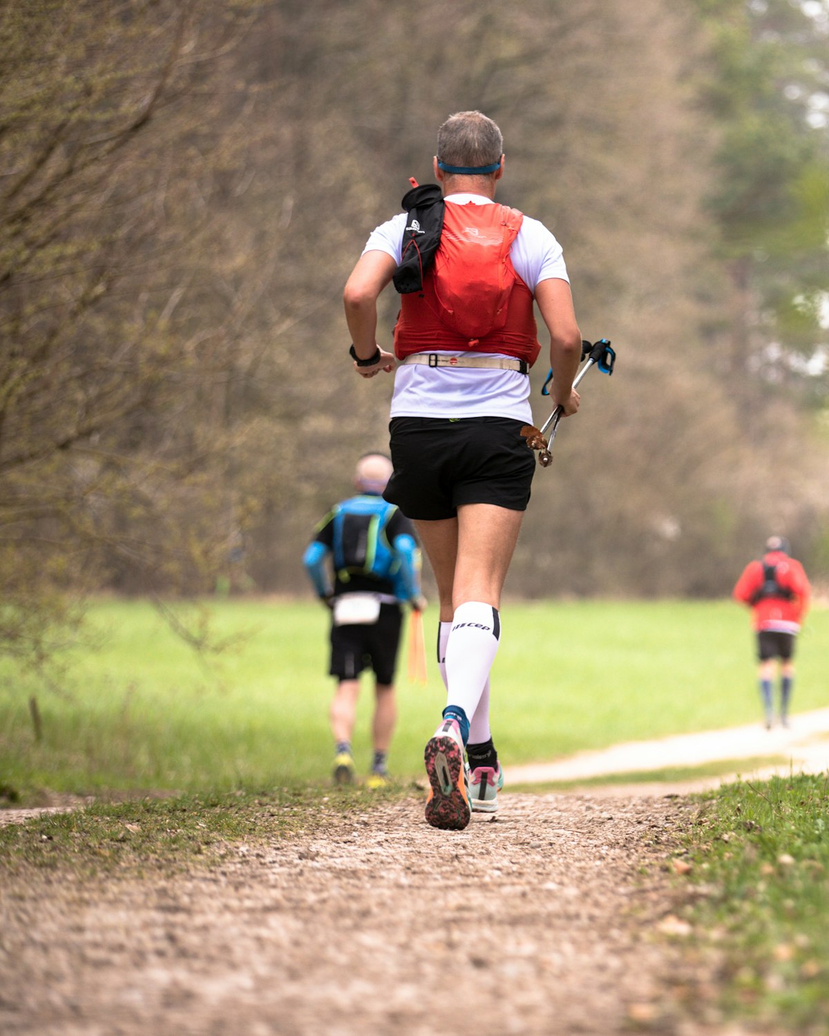
Kyzikos Ultra is a trail running event held around ancient Kyzikos in the Marmara region, bringing together nature and trail running with short-distance and ultra courses.
Courses
| Course | Distance | Elevation Gain | Km-effort | Fee | Course file |
|---|---|---|---|---|---|
| 65K | 65 km | 2084 m D+ | 86 | 4,810 ₺ | GPX |
| 35K | 35 km | 939 m D+ | 44 | 4,410 ₺ | GPX |
| 22K | 22 km | 446 m D+ | 26 | 3,510 ₺ | GPX |
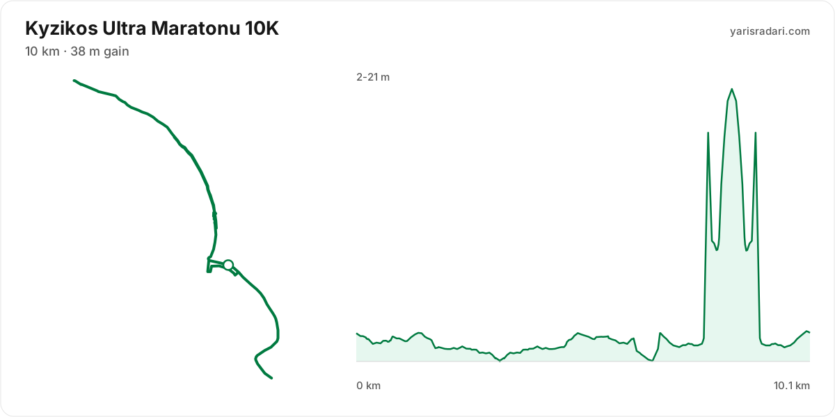
| 10K | 10 km | 38 m D+ | 10 | 3,210 ₺ | GPX |
| 5K | 5 km | 2,710 ₺ | GPX | ||
| Team Race 5K | 5 km | 2,710 ₺ |
There are 6 courses: 65K (2084 m D+); 35K (939 m D+); 22K (446 m D+); 10K (38 m D+); 5K; Team Race 5K.
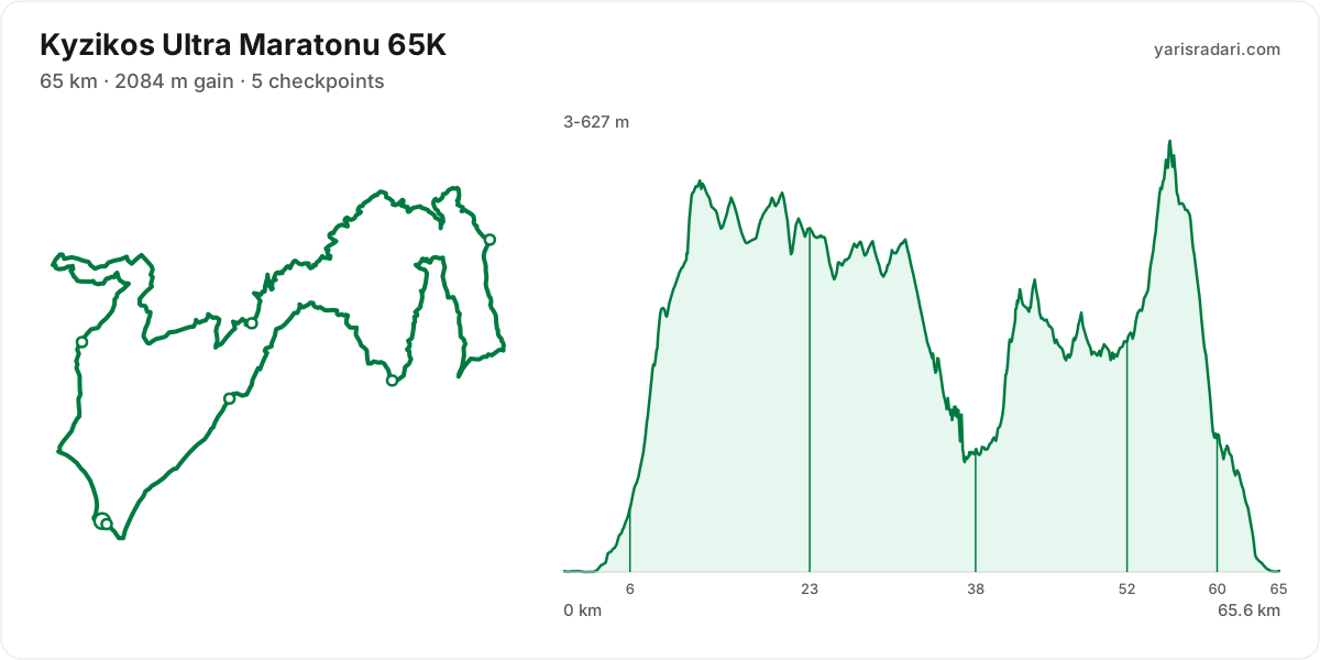
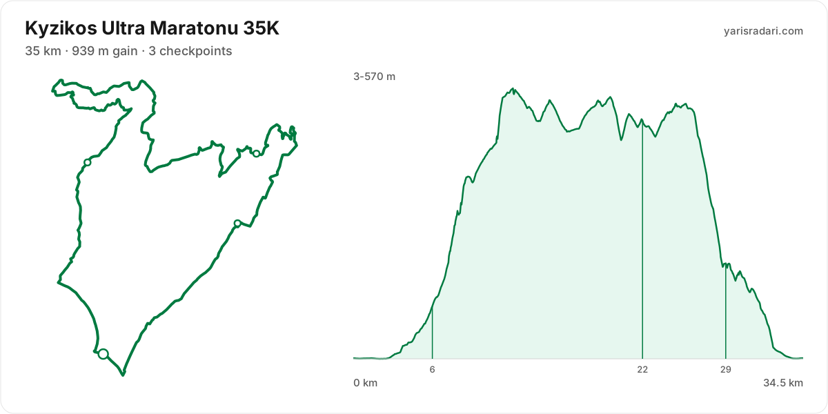
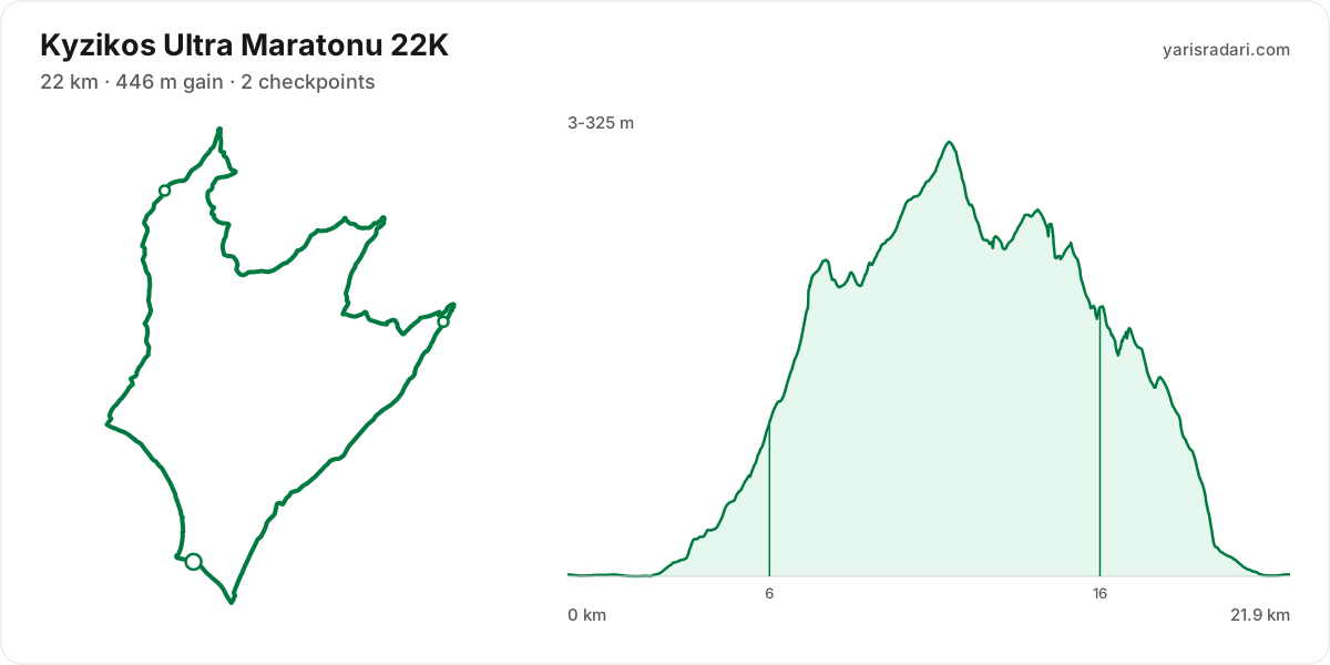
Course map and elevation profile
What the weather was on race day
- On race day the temperature ran 15°C to 24°C, and the day stayed dry, peak wind 8 km/h (calm).
- These figures come from the measurement archive after the race, not from a forecast.
- Sunrise 07:14, sunset 18:36.
The race is over. These figures come from the Open-Meteo measurement archive for that day, not from a forecast.
Race briefing
65K course66 km · 1972 m gain · 32% uphill · 5 aid stations
- Steep climb (10%+)
- Climb (3-10%)
- Flat
- Descent
- Steep descent (12%+)
The published GPX measures 66 km with 1972 m of climbing, 30 m per km. The course sits between 3 m and 629 m of altitude. 47% of the gain sits in the first half.
- 0-6.1 km · Start → Apostal Bahçe: 90 m up / 0 m down; close to flat.
- 6.1-23 km · Apostal Bahçe → Atış Poligonu: 708 m up / 299 m down; the stretch climbs.
- 23-38 km · Atış Poligonu → Manastır: 327 m up / 647 m down; the stretch descends.
- 38-52 km · Manastır → Yukarı Yapıcı: 479 m up / 324 m down; the stretch climbs.
- 52-60 km · Yukarı Yapıcı → CP Çeltikçi: 341 m up / 480 m down; the stretch descends.
- 60-66 km · CP Çeltikçi → Finish: 24 m up / 221 m down; the stretch descends.
The first 5 km are close to flat, good for settling in. Do not set your pace here, the real course starts after.
The backbone of the course runs from km 4 to km 12: 556 m over 8.7 km at 6% average, its steepest roughly 250 m section averaging 24%. Heaviest kilometres: km 9 126 m, km 8 120 m, km 12 114 m, km 7 62 m. This is hiking terrain, not running terrain. Walk it with intent and keep your heart rate off the ceiling.
The climb between km 37 and km 43: net 263 m over 6.5 km at 4% average, its steepest roughly 250 m section averaging 21%, 349 m of climbing in total with 86 m given back. Kilometre by kilometre: km 38 20 m, km 39 18 m, km 40 36 m, km 41 124 m, km 42 81 m, km 43 39 m. Trying to run this costs far more than it saves. Shorten the stride, lean on the poles, keep moving.
The late climb from km 49 to km 56: net 292 m over 6.5 km at 4% average, its steepest roughly 250 m section averaging 15%, 363 m of climbing in total with 71 m given back. Heaviest kilometres: km 55 112 m, km 54 88 m, km 56 74 m, km 53 47 m. By the time you start it, about 79% of the day's climbing is behind you. At this point in the day most runners walk this gradient. Settle into a hiking rhythm and let the metres come.
The longest descent starts at km 56 and loses 586 m by km 64 at 8% average, its steepest roughly 250 m section averaging 21%. Its length can load the quads, so begin under control and build rhythm only when the ground and visibility allow it. The drop at km 31 averages 24% over its steepest roughly 250 m section; shorten the stride, stay balanced and set speed to the ground instead of braking continuously.
The last 6 km drop 193 m. If anything is left in your legs, spend it here.
The leg from Apostal Bahçe to Atış Poligonu is long and unsupported: 16 km and 708 m of climbing with no aid in between, so leave Apostal Bahçe with full capacity.
You reach the climb after Manastır with about 647 m of descent already in your quads; treat its first half as recovery effort.
- The organiser lists 2084 m of climbing; the published GPX measures 1972 m. The technical course notes use the published GPX measurement.
- This course reaches 629 m. A separate forecast for the high-point coordinate gives 10°C to 20°C, wind up to 8 km/h (calm). It is a daily forecast for that coordinate, so arrival time can still change what you encounter.
- Consider bringing poles. The course averages 30 m of gain per km and the longest climb averaging over 5% runs 8.7 km; if you have trained with them and the organiser allows them, use them on the climbs and stow them on runnable ground.
Course-profile notes are generated from GPX grade data; terrain, rules, aid stations and weather are added only when separately sourced.
Aid stations
Key decision points
CP1 Apostal Bahçekm 6.1
- The heaviest leg is next: 16 km with 708 m of climbing.
- The longest unsupported stretch starts here: 16 km. Leave with full capacity.
CP3 Manastırkm 38
- A heavy leg is next: 14 km with 479 m of climbing.
- A 21% pitch starts about 2.3 km after the station; do not enter it cooled down.
- The longest stretch between official aid stations runs from CP1 Apostal Bahçe (km 6) to CP2 Atış Poligonu (km 23): 16 km, with 708 m of climbing in between. Top up at CP1 Apostal Bahçe and size what you carry to the expected duration and your own drinking rate.
- Another heavy leg runs from CP3 Manastır (km 38) to CP4 Yukarı Yapıcı (km 52): 14 km with 479 m of climbing. Treat it as the slowest part of your day and get your food out before it.
- About 2 km after CP3 Manastır (km 38), a roughly 250 m section averaging 21% begins. Enter the climb at a controlled effort.
| Station | Km | From previous |
|---|---|---|
| CP1 Apostal Bahçe | 6.1 | 6.1 |
| CP2 Atış Poligonu | 23 | 16 |
| CP3 Manastır | 38 | 15 |
| CP4 Yukarı Yapıcı | 52 | 14 |
| CP Çeltikçi | 60 | 8.2 |
| Finish Erdek Meydan | 65 | 5.5 |
Aid station details come from the list published by the organiser; confirm them at the official source before race day.
35K course35 km · 914 m gain · 36% uphill · 3 aid stations
- Steep climb (10%+)
- Climb (3-10%)
- Flat
- Descent
- Steep descent (12%+)
The published GPX measures 35 km with 914 m of climbing, 26 m per km. The course sits between 3 m and 570 m of altitude. 72% of the gain sits in the first half.
- 0-6.1 km · Start → Apostal Bahçe: 111 m up / 0 m down; close to flat.
- 6.1-22 km · Apostal Bahçe → Atış Poligonu: 688 m up / 300 m down; the stretch climbs.
- 22-29 km · Atış Poligonu → Çeltikçi: 83 m up / 389 m down; the stretch descends.
- 29-35 km · Çeltikçi → Finish: 31 m up / 225 m down; the stretch descends.
The first 2.8 km are close to flat, good for settling in. Do not set your pace here, the real course starts after.
The backbone of the course runs from km 4 to km 12: 556 m over 8.7 km at 6% average, its steepest roughly 250 m section averaging 24%. Heaviest kilometres: km 8 134 m, km 12 103 m, km 9 94 m, km 7 64 m. This is hiking terrain, not running terrain. Walk it with intent and keep your heart rate off the ceiling.
The longest descent starts at km 26 and loses 507 m by km 33 at 8% average, its steepest roughly 250 m section averaging 18%. Its length can load the quads, so begin under control and build rhythm only when the ground and visibility allow it.
The last 4.1 km drop 146 m. If anything is left in your legs, spend it here.
The leg from Apostal Bahçe to Atış Poligonu is long and unsupported: 16 km and 688 m of climbing with no aid in between, so leave Apostal Bahçe with full capacity.
- This course reaches 570 m. A separate forecast for the high-point coordinate gives 10°C to 20°C, wind up to 8 km/h (calm). It is a daily forecast for that coordinate, so arrival time can still change what you encounter.
- Consider bringing poles. The course averages 26 m of gain per km and the longest climb averaging over 5% runs 8.7 km; if you have trained with them and the organiser allows them, use them on the climbs and stow them on runnable ground.
- The climbing is stacked into the first half. Start easy; even with less climbing later, the descents and accumulated fatigue still have to be managed.
Course-profile notes are generated from GPX grade data; terrain, rules, aid stations and weather are added only when separately sourced.
Aid stations
Key decision points
CP1 Apostal Bahçekm 6.1
- The heaviest leg is next: 16 km with 688 m of climbing.
- The longest unsupported stretch starts here: 16 km. Leave with full capacity.
- A 17% pitch starts about 2 km after the station; do not enter it cooled down.
- The longest stretch between official aid stations runs from CP1 Apostal Bahçe (km 6) to CP2 Atış Poligonu (km 22): 16 km, with 688 m of climbing in between. Top up at CP1 Apostal Bahçe and size what you carry to the expected duration and your own drinking rate.
- About 2 km after CP1 Apostal Bahçe (km 6), a roughly 250 m section averaging 17% begins. Enter the climb at a controlled effort.
| Station | Km | From previous |
|---|---|---|
| CP1 Apostal Bahçe | 6.1 | 6.1 |
| CP2 Atış Poligonu | 22 | 16 |
| CP3 Çeltikçi | 29 | 6.4 |
| Finish Erdek Meydan | 35 | 6.4 |
Aid station details come from the list published by the organiser; confirm them at the official source before race day.
22K course22 km · 427 m gain · 23% uphill · 2 aid stations
- Climb (3-10%)
- Flat
- Descent
The published GPX measures 22 km with 427 m of climbing, 20 m per km. The course sits between 3 m and 325 m of altitude. 74% of the gain sits in the first half.
- 0-6.1 km · Start → Apostal Bahçe: 111 m up / 0 m down; close to flat.
- 6.1-16 km · Apostal Bahçe → Çeltikçi: 290 m up / 207 m down; the stretch keeps rolling.
- 16-22 km · Çeltikçi → Finish: 28 m up / 223 m down; the stretch descends.
The first 1.7 km are close to flat, good for settling in. Do not set your pace here, the real course starts after.
The backbone of the course runs from km 4 to km 12: 309 m over 8.1 km at 4% average, its steepest roughly 250 m section averaging 11%. Heaviest kilometres: km 8 65 m, km 7 64 m, km 6 48 m, km 10 38 m. This is hiking terrain, not running terrain. Walk it with intent and keep your heart rate off the ceiling.
The longest descent starts at km 12 and loses 301 m by km 20 at 4% average, its steepest roughly 250 m section averaging 13%. Its length can load the quads, so begin under control and build rhythm only when the ground and visibility allow it.
The last 2.6 km drop 64 m. If anything is left in your legs, spend it here.
- This course reaches 325 m. A separate forecast for the high-point coordinate gives 11°C to 21°C, wind up to 8 km/h (calm). It is a daily forecast for that coordinate, so arrival time can still change what you encounter.
- Sunset is 18:36, 10 hours 6 minutes after the gun. If your target time is longer than that, carry a headtorch whether or not the rules demand one.
- Poles are optional: 20 m of gain per km. Bring them to protect your legs, not to gain speed.
- The climbing is stacked into the first half. Start easy; even with less climbing later, the descents and accumulated fatigue still have to be managed.
Course-profile notes are generated from GPX grade data; terrain, rules, aid stations and weather are added only when separately sourced.
Aid stations
Key decision points
CP1 Apostal Bahçekm 6.1
- The heaviest leg is next: 10 km with 290 m of climbing.
- The longest unsupported stretch starts here: 10 km. Leave with full capacity.
- A 11% pitch starts about 0.8 km after the station; do not enter it cooled down.
- The longest stretch between official aid stations runs from CP1 Apostal Bahçe (km 6) to CP2 Çeltikçi (km 16): 10 km, with 290 m of climbing in between. Top up at CP1 Apostal Bahçe and size what you carry to the expected duration and your own drinking rate.
- About 0.8 km after CP1 Apostal Bahçe (km 6), a roughly 250 m section averaging 11% begins. Enter the climb at a controlled effort.
| Station | Km | From previous |
|---|---|---|
| CP1 Apostal Bahçe | 6.1 | 6.1 |
| CP2 Çeltikçi | 16 | 10 |
| Finish | 22 | 5.9 |
Aid station details come from the list published by the organiser; confirm them at the official source before race day.
10K course10 km · 33 m gain · 0% uphill
- Flat
The published GPX measures 10 km with 33 m of climbing, 3 m per km.
The first 1.5 km are close to flat, good for settling in. Do not set your pace here, the real course starts after.
The last 2 km are close to flat. Plan your finishing pace around that, there is nothing left to save.
- Sunset is 18:35, 9 hours 5 minutes after the gun. If your target time is longer than that, carry a headtorch whether or not the rules demand one.
- The profile does not show a clear need for poles: 3 m of gain per km. If you are not used to them, running with your hands free may be more comfortable.
- The route passes the start area 2 times, but the loops differ; the later section is ground you have not seen.
- At km 5.8 you pass right by the finish area with 4.2 km still to go; the noise there breaks more races than the climbs do.
Course-profile notes are generated from GPX grade data; terrain, rules, aid stations and weather are added only when separately sourced.
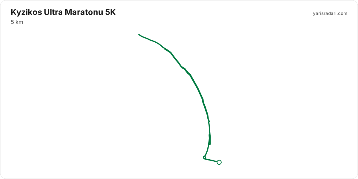
5K course5 km · no elevation data
- Sunset is 18:35, 8 hours 35 minutes after the gun. If your target time is longer than that, carry a headtorch whether or not the rules demand one.
- A single loop: start and finish share the same spot. Around 30% of the ground is covered twice.
The organiser's GPX file has no elevation data, so the grade profile and kilometre analysis cannot be shown for this course; the notes below come from the shape of the route itself.
2024 results
- In 2024, 889 runners completed the race across 4 courses.
- 104 runners started the 65 km course and 98 finished, 6% did not finish, the winner took 5:42:44 and the median was 8:17:29, nine in ten finishers came in under 10:28:46.
- 215 runners started the 35 km course and 212 finished, 1% did not finish, the winner took 2:30:51 and the median was 3:57:36, nine in ten finishers came in under 4:50:59.
- 348 runners started the 20 km course and 342 finished, 2% did not finish, the winner took 1:26:57 and the median was 2:33:02, nine in ten finishers came in under 3:37:05.
- 240 runners started the 5 km course and 237 finished, 1% did not finish, the winner took 15:37 and the median was 30:26, nine in ten finishers came in under 46:54.
| Course | Finished / started | Did not finish | Winner | Median |
|---|---|---|---|---|
| 65 km65K Suunto | 98 / 104 | 6% | 5:42:44 | 8:17:29 |
| 35 km35K Arteka | 212 / 215 | 1% | 2:30:51 | 3:57:36 |
| 20 km20K Apostol | 342 / 348 | 2% | 1:26:57 | 2:33:02 |
| 5 km5K Umut Pina | 237 / 240 | 1% | 15:37 | 30:26 |
Calculators for this race
Registration
- StandardMon, Feb 2, 2026 - Sun, Oct 4, 20262,710 ₺Entries closed
- Late RegistrationMon, Oct 5, 2026 - Mon, Oct 5, 20262,710 ₺Entries closed
- Early BirdSun, Feb 1, 20261,210 ₺Entries closed
Data sources: PassTiming race calendar, official site (kyzikosultra.com) · Last checked:
Organising this race? See how to correct details and complete this page
Similar races
Frequently asked questions
(34)
What is Kyzikos Ultra Maratonu?
Kyzikos Ultra is a trail running event held around ancient Kyzikos in the Marmara region, bringing together nature and trail running with short-distance and ultra courses.
When is Kyzikos Ultra Maratonu 2026?
Kyzikos Ultra Maratonu takes place on Sat, Oct 10, 2026 - Sun, Oct 11, 2026.
Where does Kyzikos Ultra Maratonu take place?
Kyzikos Ultra Maratonu takes place in Balıkesir.
What are the courses and distances of Kyzikos Ultra Maratonu 2026?
Kyzikos Ultra Maratonu offers 6 courses: 65K (65 km, 2084 m D+); 35K (35 km, 939 m D+); 22K (22 km, 446 m D+); 10K (10 km, 38 m D+); 5K (5 km); Team Race 5K (5 km).
How hard is Kyzikos Ultra Maratonu 2026?
Difficulty is measured in km-effort: distance plus ascent divided by 100. The 65K course covers 65 km with 2084 m of climbing, which is 86 km-effort and falls in ITRA category M. All courses: 65K 86 km-effort (M), 35K 44 km-effort (XS), 22K 26 km-effort (XS), 10K 10 km-effort (XXS).
Is registration for Kyzikos Ultra Maratonu 2026 open?
The 2026 edition has taken place; registration is closed. Follow the official site and Yarış Radarı for the next edition: https://yarisradari.com/en/yaris/kyzikos-ultra
Where are the Kyzikos Ultra Maratonu 2026 results?
The Kyzikos Ultra Maratonu 2026 result list is published by the organiser at: https://argeustiming.com/results/g-live/g-live.html?f=../kyzikos/2024/kyzikos2024.clax
Where are the Kyzikos Ultra Maratonu photos?
Kyzikos Ultra Maratonu photos are in the organiser's gallery: https://www.kyzikosultra.com/fotograflar/. The gallery may also cover earlier editions.
What is the official website of Kyzikos Ultra Maratonu?
Official website: https://www.kyzikosultra.com/
Is a medical certificate required for Kyzikos Ultra Maratonu?
Yes, a medical certificate is required. See the organiser's official page for the exact wording.
Is the Kyzikos Ultra Maratonu 2026 course a loop or an out and back?
The 65K course is a single loop with a shared start and finish; measured from the GPX file it runs 65.6 km. The 35K course is a single loop with a shared start and finish; measured from the GPX file it runs 34.5 km. The 22K course is a single loop with a shared start and finish; measured from the GPX file it runs 21.9 km.
Where is the hardest climb at Kyzikos Ultra Maratonu 2026?
The biggest climb on the 65K course runs from km 4 to km 12: 8.7 km for 556 m at 6% average; its steepest roughly 250 m section averages 24%. It tops out at 570 m.
How high does Kyzikos Ultra Maratonu 2026 go?
The 65K course runs between 3 m and 629 m with 1972 m of total climbing.
Do you need poles at Kyzikos Ultra Maratonu 2026?
The 65K course averages 30 m of gain per km with a longest climb of 8.7 km, so poles help noticeably.
Do you need a headtorch at Kyzikos Ultra Maratonu 2026?
22K: Sunset is 18:36, 10 hours 6 minutes after the gun. If your target time is longer than that, carry a headtorch whether or not the rules demand one.
What was the weather like at Kyzikos Ultra Maratonu 2026?
On race day the temperature ran 15°C to 24°C, and the day stayed dry, peak wind 8 km/h. These figures come from the measurement archive.
Where are the aid stations at Kyzikos Ultra Maratonu 2026?
The 65K course has 5 stations; the first at km 6 and the last at km 60. The longest gap between them is 16 km, between CP1 Apostal Bahçe and CP2 Atış Poligonu.
What time does Kyzikos Ultra Maratonu 2026 start?
Known start times: 22K 08:30, 10K 09:30, 5K 10:00, local time. Confirm against the organiser's schedule in race week.
Is there a GPX file for Kyzikos Ultra Maratonu 2026?
Yes. The GPX files for the 65K, 35K, 22K, 10K, 5K courses can be downloaded from the course section on this page, next to the route map. Where the organiser's GPX file has no elevation data, there is no grade profile.
Which Kyzikos Ultra Maratonu course should you choose?
The shortest option is 5K (5 km) and the longest is 65K (65 km, 2084 m D+). With little trail experience the 5K is the safer start; the 65K demands an all-day effort and cut-off management.
What are the gradients like at Kyzikos Ultra Maratonu 2026?
The 65K course averages 30 m of climbing per km, with 1972 m of total ascent and 1971 m of descent. The steepest kilometre averages 14%.
How runnable is the Kyzikos Ultra Maratonu 2026 course?
Expect a mix of running and power hiking: 30 m of gain per km; hiking the long climbs is normal, and the longest climb runs 8.7 km.
Where is the steepest part of Kyzikos Ultra Maratonu 2026?
The steepest kilometre of the 65K course averages 14% and sits inside the climb between km 4 and km 12.
How many climbs does Kyzikos Ultra Maratonu 2026 have?
The 65K course has 4 distinct climbs. The biggest: km 4-12 (556 m at 6%); km 49-56 (292 m at 4%); km 37-43 (263 m at 4%).
Is there a long climb at Kyzikos Ultra Maratonu 2026?
Yes. The longest climb runs 8.7 km from km 4, gaining 556 m at 6% average, topping out at 570 m.
What are the descents like at Kyzikos Ultra Maratonu 2026?
There is 1971 m of descent in total. The longest drop runs 7.7 km between km 56 and km 64, losing 586 m.
Are there flat sections at Kyzikos Ultra Maratonu 2026?
Partly: about 41% of the course is near flat, the rest climbs or descends.
Is the hard part of Kyzikos Ultra Maratonu 2026 early or late?
The climbing is evenly split: 47% of it sits in the first half.
What is the elevation range at Kyzikos Ultra Maratonu 2026?
The lowest point of the 65K course sits at 3 m and the highest at 629 m, a range of 626 m.
Where does Kyzikos Ultra Maratonu 2026 reach its high point?
The course tops out at 629 m, reached around km 56.
Are poles mandatory at Kyzikos Ultra Maratonu 2026?
The organiser has not announced a pole requirement. Based on the profile poles help noticeably.
Do you need to carry water at Kyzikos Ultra Maratonu 2026?
Yes: the longest stretch without aid on the 65K course is 16.4 km, so carrying backup water is essential.
When is Kyzikos Ultra Maratonu 2027?
The date for Kyzikos Ultra Maratonu 2027 has not been announced yet. It will appear on this page once the organiser confirms it: https://yarisradari.com/en/yaris/kyzikos-ultra
Will Kyzikos Ultra Maratonu 2026 take place?
Kyzikos Ultra Maratonu status: Completed.