Malaysia Ultra-Trail by UTMBTaiping, Malaysia🇲🇾
Completed

About Malaysia Ultra-Trail by UTMB 2026
Malaysia Ultra-Trail by UTMB 2026 was a trail race held from Fri, Sep 11, 2026 to Sun, Sep 13, 2026 in Taiping, Malaysia; the start is at 05:00.
The 2026 edition is over; registration is closed. The next edition is added to the calendar automatically once the organiser announces a date.
The Malaysia Ultra-Trail by UTMB will be held in Taiping, a small historic city in the northwest of Peninsular Malaysia. Runners will compete in four different distances: MY13, MY25, MY50, and MY100, striving for excellent results.
Courses
There are 3 courses: 100K; 50K; 20K.
Course map and elevation profile
What the weather was on race day
- On race day the temperature ran 25°C to 30°C, with 17 mm of rain through the day, peak wind 8 km/h (calm).
- These figures come from the measurement archive after the race, not from a forecast.
- Sunrise 07:08, sunset 19:18. You start in the dark, so a headtorch is not optional.
The race is over. These figures come from the Open-Meteo measurement archive for that day, not from a forecast.
Race briefing
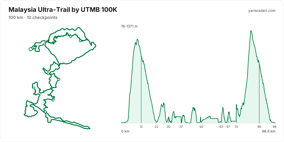
100K course97 km · 6143 m gain · 10 aid stations
The station table gives 99 km with 6151 m of climbing, 62 m per km. The same table lists 6144 m of descent. By leg totals, roughly 51% of the gain sits in the first half.
The steepest leg runs Peak 300 to Angkasa: 14 km for 1607 m, 112 m per km, 81% above the course average. Nobody runs this on tired legs. Hike it with intent and let the clock do what it wants.
The last 3.3 km drop 53 m. Spend whatever is left, but your quads will already be cooked.
These are leg totals. The table does not say where inside a leg the climbing sits, so the steep parts of a leg will be harder than its average.
- The organiser lists 100 km; the published GPX measures 96.6 km. The course notes use the GPX for route shape and the aid-station table for climbing.
- Start 03:00, sunrise 07:08: the first 4 hours 8 minutes are run in the dark. The headtorch goes on your head at the start, not in your pack.
- Sunset is 19:18 and the finish cut-off is 11:00. A runner using the full time allowance spends the final 11 hours 50 minutes in darkness.
- Get the headtorch out before sunset and keep spare batteries or a power bank dry and immediately accessible. A spare buried at the bottom of the pack is not an emergency spare.
- Check reflective course markers regularly in the dark. If the markings disappear, stop moving forward, return to the last marker and confirm the route against the GPX or organiser app.
- Poles are strongly recommended for this profile. The table gives 62 m of gain per km and the heaviest leg runs at 112 m per km. If you have trained with them and the organiser allows them, they can help share the load on the climbs.
- The file measures 96.6 km against the advertised 100 km, so expect your watch to disagree with the signs.
The organiser's GPX file has no elevation data, so the grade profile and kilometre analysis cannot be shown for this course; climb figures come from the aid station table.
Aid stations
Key decision points
Maxwell Basecampkm 22
- Collect food and fluids and leave within 60-90 seconds.
- A heavy leg is next: 7.6 km with 387 m of climbing.
- Cut-off: 8h after the start.
Spritzer Ecoparkkm 37
- Collect food and fluids and leave within 60-90 seconds.
- Crew access is allowed here.
- A heavy leg is next: 13 km with 549 m of climbing.
Changkat Ibol Junctionkm 63
- Collect food and fluids and leave within 60-90 seconds.
- Your drop bag waits here; work off your prepared list.
- Crew access is allowed here.
- A heavy leg is next: 4.4 km with 266 m of climbing.
- Cut-off: 20h after the start.
U-turn Kuning Sarikm 67
- Take hot food you digest easily and top up fluids.
- A heavy leg is next: 5.1 km with 359 m of climbing.
Peak 300km 72
- Collect food and fluids and leave within 60-90 seconds.
- The heaviest leg is next: 14 km with 1607 m of climbing.
- The longest unsupported stretch starts here: 14 km. Leave with full capacity.
- Cut-off: 23h after the start.
- The longest stretch between official aid stations runs from Peak 300 (km 72) to Angkasa (km 86): 14 km, with 1607 m of climbing in between. Top up at Peak 300 and size what you carry to the expected duration and your own drinking rate.
- Hot food is served at U-turn Kuning Sari (km 67). If your stomach and race plan call for it, make this a deliberate 3-5 minute stop; do not sit down simply because hot food is available. Restart gently and let your stomach settle before lifting the effort.
- Food is available at Angkasa (km 12) and Maxwell Basecamp (km 22) and 7 more. Decide what you need before reaching the table; without a planned special task, collect food and fluids and leave within 60-90 seconds. Finish eating on the next calm, suitable section.
- Drop bag at Changkat Ibol Junction (km 63). Write down the equipment and food you expect to replace before the race so the decision is already made when you arrive.
- Crew support is permitted only at Spritzer Ecopark (km 37), Changkat Ibol Junction (km 63), and Finish (km 99). This is not the same as a drop bag: plan equipment and food hand-offs around these stations, then verify wristband, bag and transport rules with the organiser.
- Another heavy leg runs from Start (km 0) to Angkasa (km 12): 12 km with 1335 m of climbing. Treat it as the slowest part of your day and get your food out before it.
- Medical support is available at Start (km 0), Angkasa (km 12), Maxwell Basecamp (km 22), Tiger Temple (km 30), KTM Tunnel (km 50), Changkat Ibol Junction (km 63), U-turn Kuning Sari (km 67), Peak 300 (km 72), Angkasa (km 86), Maxwell Basecamp (km 96), and Finish (km 99). If something is wrong with your feet or your stomach, deal with it there rather than pushing on.
- The overall cut-off is 32h, including all checkpoint stops. Build the plan around the official leg budgets below, not a flat-course average pace.
- Relative to distance and climbing, the tightest official time budget runs from Peak 300 (km 72) to Finish (km 99): the official time budget is 9h for 27 km and 2146 m of climbing. Station stops come out of that same budget, so do not enter the leg already behind schedule.
Official cut-off ladder
| Leg | Distance | D+ | Official time budget | Closes |
|---|---|---|---|---|
| Start → Maxwell Basecamppasses Angkasa, which has no time limit | 22 km | 1847 m | 8h | start + 8h |
| Maxwell Basecamp → Changkat Ibol Junctionpasses Tiger Temple, Spritzer Ecopark, KTM Tunnel, which has no time limit | 41 km | 1532 m | 12h | start + 20h |
| Changkat Ibol Junction → Peak 300passes U-turn Kuning Sari, which has no time limit | 9.5 km | 618 m | 3h | start + 23h |
| Peak 300 → Finishpasses Angkasa, Maxwell Basecamp, which has no time limit | 27 km | 2146 m | 9h | start + 32h |
Budgets are derived from the cut-off times published by the organiser; they are not a personal finish estimate.
| Station | Km | From previous | Supplies | Medical | Crew | Cut-off |
|---|---|---|---|---|---|---|
| StartDrop bag | 0 | — | — | Yes | No | — |
| Angkasa | 12 | 12 | Food | Yes | No | — |
| Maxwell Basecamp | 22 | 9.6 | Food | Yes | No | Saturday 11:00 |
| Tiger Temple | 30 | 7.5 | Food | Yes | No | — |
| Spritzer Ecopark | 37 | 7.8 | Food | No | Yes | — |
| KTM Tunnel | 50 | 13 | Food | Yes | No | — |
| Changkat Ibol JunctionDrop bag | 63 | 12 | Food | Yes | Yes | Saturday 23:00 |
| U-turn Kuning Sari | 67 | 4.4 | Hot food | Yes | No | — |
| Peak 300 | 72 | 5.1 | Food | Yes | No | Sunday 02:00 |
| Angkasa | 86 | 14 | Food | Yes | No | — |
| Maxwell Basecamp | 96 | 9.5 | Food | Yes | No | — |
| FinishDrop bag | 99 | 3.3 | Hot food | Yes | Yes | Sunday 11:00 |
Aid station details come from the list published by the organiser; confirm them at the official source before race day.
50K course1 km · 1750 m gain · 6 aid stations
The station table gives 54 km with 1762 m of climbing, 32 m per km. The same table lists 1744 m of descent. By leg totals, roughly 50% of the gain sits in the first half.
Leg by leg: the first 9.6 km for 339 m (Tiger Temple), the next 7.7 km for 333 m (Spritzer EcoPark), the next 5.7 km for 157 m (KTM Tunnel), the next 12 km for 183 m (Changkat Ibol), the next 4.2 km for 240 m (U-turn Kuning Sari), the next 2.5 km for 146 m (Peak 300), the last 12 km for 364 m.
The steepest leg runs U-turn Kuning Sari to Peak 300: 2.5 km for 146 m, 59 m per km, 85% above the course average. Coming this late, it decides your finishing time. Take the pressure off before you reach it.
The last 12 km still climb 364 m, 30 m per km. It does not end where you first see the finish banner, so save something for it.
These are leg totals. The table does not say where inside a leg the climbing sits, so the steep parts of a leg will be harder than its average.
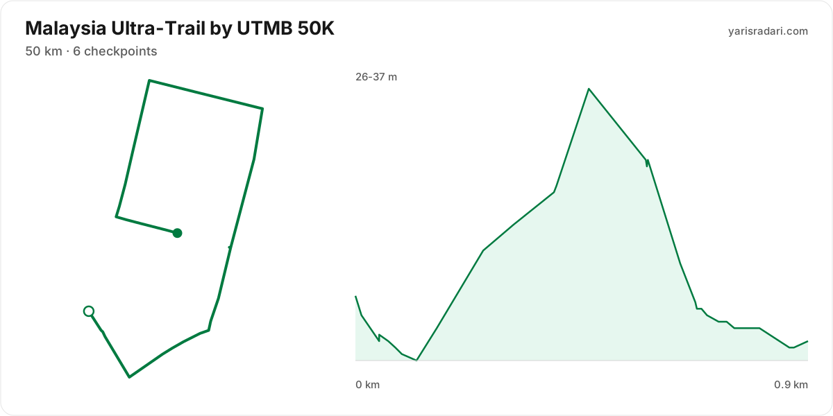
- The organiser lists 50 km; the published GPX measures 0.9 km. The course notes use the GPX for route shape and the aid-station table for climbing.
- Start 05:00, sunrise 07:08: the first 2 hours 8 minutes are run in the dark. The headtorch goes on your head at the start, not in your pack.
- Sunset is 19:18 and the finish cut-off is 22:00. A runner using the full time allowance spends the final 2 hours 42 minutes in darkness.
- Get the headtorch out before sunset and keep spare batteries or a power bank dry and immediately accessible. A spare buried at the bottom of the pack is not an emergency spare.
- Check reflective course markers regularly in the dark. If the markings disappear, stop moving forward, return to the last marker and confirm the route against the GPX or organiser app.
- Poles are strongly recommended for this profile. The table gives 32 m of gain per km and the heaviest leg runs at 59 m per km. If you have trained with them and the organiser allows them, they can help share the load on the climbs.
- The file measures 0.9 km against the advertised 50 km, so expect your watch to disagree with the signs.
The organiser's GPX file has no elevation data, so the grade profile and kilometre analysis cannot be shown for this course; climb figures come from the aid station table.
Aid stations
Key decision points
Changkat Ibolkm 36
- Collect food and fluids and leave within 60-90 seconds.
- Crew access is allowed here.
- Cut-off: 10h after the start.
- The longest stretch between official aid stations runs from KTM Tunnel (km 23) to Changkat Ibol (km 36): 12 km, with 183 m of climbing in between. Top up at KTM Tunnel and size what you carry to the expected duration and your own drinking rate.
- Food is available at Tiger Temple (km 10) and Spritzer EcoPark (km 17) and 4 more. Decide what you need before reaching the table; without a planned special task, collect food and fluids and leave within 60-90 seconds. Finish eating on the next calm, suitable section.
- Crew support is permitted only at Spritzer EcoPark (km 17) and Changkat Ibol (km 36). This is not the same as a drop bag: plan equipment and food hand-offs around these stations, then verify wristband, bag and transport rules with the organiser.
- The last aid station is Peak 300 (km 42), leaving 8 km to the finish. After that you are on what you carry.
- The heaviest leg runs from Peak 300 (km 42) to Finish (km 54): 12 km with 364 m of climbing. Treat it as the slowest part of your day and get your food out before it.
- Medical support is available at Start (km 0), Tiger Temple (km 10), Spritzer EcoPark (km 17), KTM Tunnel (km 23), Changkat Ibol (km 36), U-turn Kuning Sari (km 40), Peak 300 (km 42), and Finish (km 54). If something is wrong with your feet or your stomach, deal with it there rather than pushing on.
- The overall cut-off is 17h, including all checkpoint stops. Build the plan around the official leg budgets below, not a flat-course average pace.
- Relative to distance and climbing, the tightest official time budget runs from Start to Changkat Ibol (km 36): the official time budget is 10h for 36 km and 992 m of climbing. Station stops come out of that same budget, so do not enter the leg already behind schedule.
| Station | Km | From previous | Supplies | Medical | Crew | Cut-off |
|---|---|---|---|---|---|---|
| StartDrop bag | 0 | — | — | Yes | No | — |
| Tiger Temple | 9.6 | 9.6 | Food | Yes | No | — |
| Spritzer EcoPark | 17 | 7.7 | Food | Yes | Yes | — |
| KTM Tunnel | 23 | 5.7 | Food | Yes | No | — |
| Changkat Ibol | 36 | 12 | Food | Yes | Yes | Saturday 15:00 |
| U-turn Kuning Sari | 40 | 4.2 | Food | Yes | No | — |
| Peak 300 | 42 | 2.4 | Food | Yes | No | — |
| FinishDrop bag | 54 | 12 | Hot food | Yes | No | Saturday 22:00 |
Aid station details come from the list published by the organiser; confirm them at the official source before race day.
Calculators for this race
Registration
- StandardThu, Nov 27, 2025Entries closed
Data sources: UTMB World Series, official site (malaysia.utmb.world) · Last checked:
Similar races
Frequently asked questions
(26)
What is Malaysia Ultra-Trail by UTMB?
The Malaysia Ultra-Trail by UTMB will be held in Taiping, a small historic city in the northwest of Peninsular Malaysia. Runners will compete in four different distances: MY13, MY25, MY50, and MY100, striving for excellent results.
When is Malaysia Ultra-Trail by UTMB 2026?
Malaysia Ultra-Trail by UTMB takes place on Fri, Sep 11, 2026 - Sun, Sep 13, 2026. Start time: 05:00.
Where does Malaysia Ultra-Trail by UTMB take place?
Malaysia Ultra-Trail by UTMB takes place in Taiping, Malaysia.
What are the courses and distances of Malaysia Ultra-Trail by UTMB 2026?
Malaysia Ultra-Trail by UTMB offers 3 courses: 100K (100 km); 50K (50 km); 20K (20 km).
Is registration for Malaysia Ultra-Trail by UTMB 2026 open?
The 2026 edition has taken place; registration is closed. Follow the official site and Yarış Radarı for the next edition: https://yarisradari.com/en/yaris/malaysia-ultra-trail-by-utmb
Where are the Malaysia Ultra-Trail by UTMB 2026 results?
The Malaysia Ultra-Trail by UTMB 2026 result list is published by the organiser at: https://malaysia.utmb.world/runners/results
Where are the Malaysia Ultra-Trail by UTMB photos?
Malaysia Ultra-Trail by UTMB photos are in the organiser's gallery: https://malaysia.utmb.world/get-excited/gallery. The gallery may also cover earlier editions.
What is the official website of Malaysia Ultra-Trail by UTMB?
Official website: https://malaysia.utmb.world/
Is the Malaysia Ultra-Trail by UTMB 2026 course a loop or an out and back?
The 100K course is a single loop with a shared start and finish; measured from the GPX file it runs 96.6 km. The 50K course is a single loop with a shared start and finish; measured from the GPX file it runs 0.9 km.
Where is the hardest section at Malaysia Ultra-Trail by UTMB 2026?
The steepest leg of the 100K course runs km 72 to km 86: 14.3 km for 1607 m, 112 m per km. The figures come from the organiser's aid station table.
How much climbing does Malaysia Ultra-Trail by UTMB 2026 have?
The 100K course covers 99 km with 6151 m of climbing according to the station table, 62 m per km. The same table lists 6144 m of descent.
Do you need poles at Malaysia Ultra-Trail by UTMB 2026?
The 100K course averages 62 m of gain per km, rising to 112 m on the heaviest leg, so poles help noticeably.
Do you need a headtorch at Malaysia Ultra-Trail by UTMB 2026?
100K: Start 03:00, sunrise 07:08: the first 4 hours 8 minutes are run in the dark. The headtorch goes on your head at the start, not in your pack. Sunset is 19:18 and the finish cut-off is 11:00. A runner using the full time allowance spends the final 11 hours 50 minutes in darkness. Get the headtorch out before sunset and keep spare batteries or a power bank dry and immediately accessible. A spare buried at the bottom of the pack is not an emergency spare. Check reflective course markers regularly in the dark. If the markings disappear, stop moving forward, return to the last marker and confirm the route against the GPX or organiser app.
What was the weather like at Malaysia Ultra-Trail by UTMB 2026?
On race day the temperature ran 25°C to 30°C, with 17 mm of rain, peak wind 8 km/h. These figures come from the measurement archive.
Where are the aid stations at Malaysia Ultra-Trail by UTMB 2026?
The 100K course has 10 stations; the first at km 12 and the last at km 96. The longest gap between them is 14 km, between Peak 300 and Angkasa.
What is served at the Malaysia Ultra-Trail by UTMB 2026 aid stations?
For the 100K course: Hot food: U-turn Kuning Sari (67. km).
Is there a drop bag at Malaysia Ultra-Trail by UTMB 2026?
Yes. On the 100K course the drop bag point is Changkat Ibol Junction (km 63).
What are the cut-off times for the 100K at Malaysia Ultra-Trail by UTMB 2026?
On the 100K course at Malaysia Ultra-Trail by UTMB 2026 the finish cut-off is Sunday 11:00. Intermediate cut-offs: Maxwell Basecamp (km 22) Saturday 11:00, Changkat Ibol Junction (km 63) Saturday 23:00, Peak 300 (km 72) Sunday 02:00.
What are the cut-off times for the 50K at Malaysia Ultra-Trail by UTMB 2026?
On the 50K course at Malaysia Ultra-Trail by UTMB 2026 the finish cut-off is Saturday 22:00. Intermediate cut-offs: Changkat Ibol (km 36) Saturday 15:00.
What time does Malaysia Ultra-Trail by UTMB 2026 start?
Known start times: 100K 03:00, 50K 05:00, local time. Confirm against the organiser's schedule in race week.
What is the time limit at Malaysia Ultra-Trail by UTMB 2026?
The finish time limit is 100K Sunday 11:00, 50K Saturday 22:00. Intermediate stations carry their own cut-offs; the full list is in the checkpoint table on this page.
Is there a GPX file for Malaysia Ultra-Trail by UTMB 2026?
Yes. The GPX files for the 100K, 50K courses can be downloaded from the course section on this page, next to the route map. Where the organiser's GPX file has no elevation data, there is no grade profile.
Which Malaysia Ultra-Trail by UTMB course should you choose?
The shortest option is 20K (20 km) and the longest is 100K (100 km). With little trail experience the 20K is the safer start; the 100K demands an all-day effort and cut-off management.
Do you need to carry water at Malaysia Ultra-Trail by UTMB 2026?
Yes: the longest stretch without aid on the 100K course is 14.3 km, so carrying backup water is essential.
When is Malaysia Ultra-Trail by UTMB 2027?
The date for Malaysia Ultra-Trail by UTMB 2027 has not been announced yet. It will appear on this page once the organiser confirms it: https://yarisradari.com/en/yaris/malaysia-ultra-trail-by-utmb
Will Malaysia Ultra-Trail by UTMB 2026 take place?
Malaysia Ultra-Trail by UTMB status: Completed.