Tahtalı Run to SkyKemer, Antalya🇹🇷

About Tahtalı Run to Sky 2027
Tahtalı Run to Sky 2027 is a trail race held from Sat, May 8, 2027 to Sun, May 9, 2027 in Kemer, Antalya.
Registration is taken on the official site; no deadline has been announced. Dates, registration windows and fees on this page are refreshed every morning by scanning federation, timing and organiser sites; registration always happens on the official race site.
Someone running 30 km a week needs 16 weeks, about 3.5 months, to prepare for the 41K Phaselis Run course of Tahtalı Run to Sky 2027; the latest start is Sat, Jan 16, 2027.
Courses
| Course | Distance | Elevation Gain | Km-effort | Fee | Course file |
|---|---|---|---|---|---|
| 41K Phaselis Run | 41 km | 1212 m D+ | 53 | 2,250 ₺ | |
| 27K Run to Sky | 27 km | 2666 m D+ | 54 | 2,750 ₺ | GPX |
| 12K KemeRun | 12 km | 373 m D+ | 16 | 1,800 ₺ | GPX |
A federation fee is added to these prices at registration.
There are 3 courses: 41K Phaselis Run (1212 m D+); 27K Run to Sky (2666 m D+); 12K KemeRun (373 m D+).
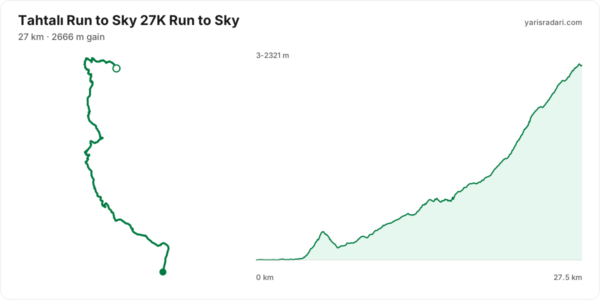
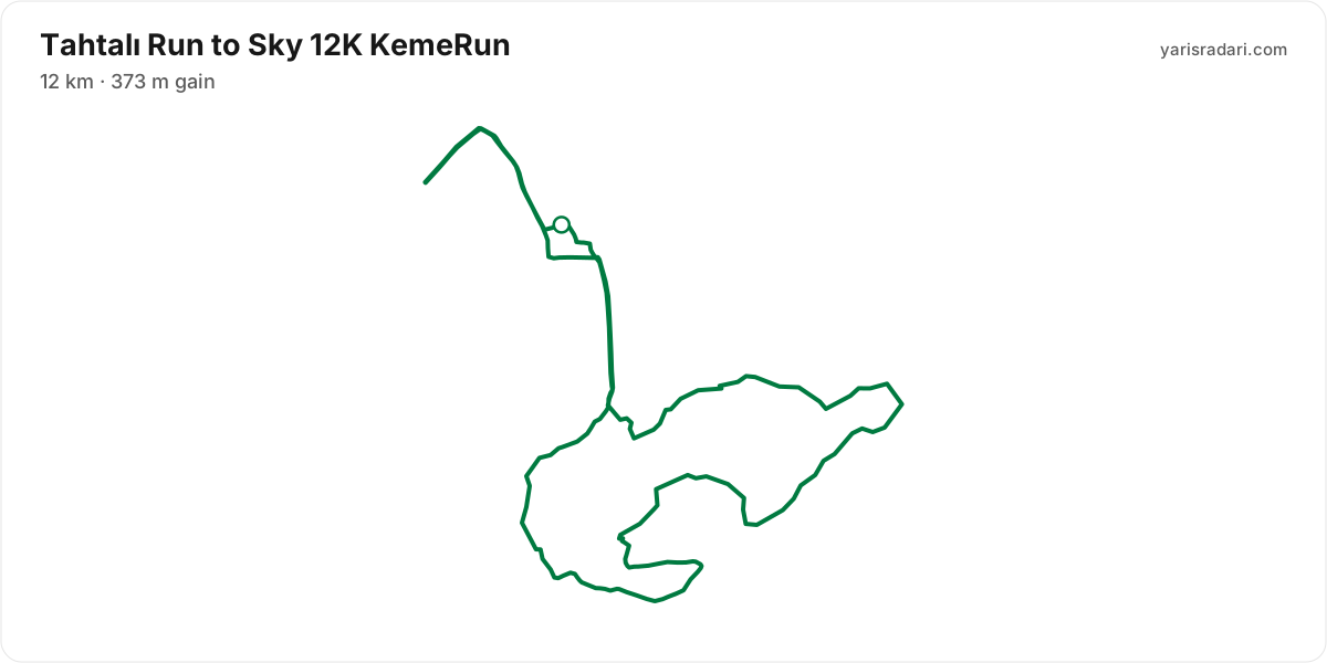
Course map and elevation profile
What the weather is usually like here
- Over the last 5 years this week typically ran 18°C to 24°C here, with a high of 28°C and a low of 14°C.
- 14% of those days saw rain. A real forecast lands about two weeks out and will appear here then.
- Typical daily maximum wind was 17 km/h (a light breeze), with 30 km/h the highest value in the sample.
- Sunrise 05:57, sunset 19:51.
The race is more than two weeks out, so these are averages of recent years for the same week, not a forecast. A real forecast appears here closer to the day.
Race briefing
27K Run to Sky course28 km · 2984 m gain · 68% uphill
- Steep climb (10%+)
- Climb (3-10%)
- Flat
- Steep descent (12%+)
The published GPX measures 28 km with 2984 m of climbing, 108 m per km. The course sits between 3 m and 2321 m of altitude. 30% of the gain sits in the first half.
The first 2.2 km are close to flat, good for settling in. Do not set your pace here, the real course starts after.
The backbone of the course runs from km 2 to km 27: net 2315 m over 25 km at 9% average, its steepest roughly 250 m section averaging 35% on the GPX trace, 2958 m of climbing in total with 643 m given back. It tops out at 2319 m. Heaviest kilometres: km 23 242 m, km 24 212 m, km 22 205 m, km 17 184 m. This is hiking terrain, not running terrain. Walk it with intent and keep your heart rate off the ceiling.
The longest descent starts at km 6 and loses 188 m by km 7 at 15% average, its steepest roughly 250 m section averaging 22%. Its length can load the quads, so begin under control and build rhythm only when the ground and visibility allow it.
The last 3.3 km climb 498 m to the line. Know it going in and save something for it.
- The organiser lists 27 km; the published GPX measures 27.5 km. The organiser lists 2666 m of climbing; the published GPX measures 2984 m. The technical course notes use the published GPX measurement.
- This course reaches 2321 m. At the high-point coordinate, the same week historically ran 1°C to 13°C. Typical daily maximum wind was 9 km/h, reaching 15 km/h in the sample. This is climate history, not the race-day forecast; keep the shell accessible if race week looks similar.
- Poles are strongly recommended for this profile. The course averages 108 m of gain per km and the longest climb averaging over 5% runs 25 km; if you have trained with them and the organiser allows them, use them on the climbs and stow them on runnable ground.
- Most of the climbing waits in the second half. Feeling good early is a trap here.
- The high point is 2321 m. Coming from sea level, your heart rate and breathing shift at the same pace, so leave yourself room in the first hour.
- The altitude is not a single summit: about 3.6 km of the course sits above 1800 m. The longest unbroken stretch up high is 3.6 km and the high zone spans roughly km 24 to km 28.
- Point to point: the finish sits 14.7 km from the start as the crow flies. Sort the shuttle and your drop bag before race day.
Course-profile notes are generated from GPX grade data; terrain, rules, aid stations and weather are added only when separately sourced.
12K KemeRun course12 km · 373 m gain
- The route passes the start area 2 times, but the loops differ; the later section is ground you have not seen.
The organiser's GPX file has no elevation data, so the grade profile and kilometre analysis cannot be shown for this course; the climb figure is the one the organiser advertises.
2023 results
- In 2023, 398 runners completed the race across 3 courses.
- 44 runners started the 65 km course and 34 finished, 23% did not finish, the winner took 9:04:03 and the median was 11:58:00, nine in ten finishers came in under 14:16:00.
- 235 runners started the 27 km course and 214 finished, 9% did not finish, the winner took 3:25:39 and the median was 6:05:03, nine in ten finishers came in under 7:33:00.
- On the 27 km course the most common stopping point was ULUPINAR (km 9.6), where 13 runners ended their race.
- 164 runners started the 12 km course and 150 finished, 9% did not finish, the winner took 58:34 and the median was 1:53:22, nine in ten finishers came in under 2:23:57.
| Course | Finished / started | Did not finish | Winner | Median |
|---|---|---|---|---|
| 65 kmBERG SKY RACE (65K) | 34 / 44 | 23% | 9:04:03 | 11:58:00 |
| 27 kmTAHTALI RUN TO SKY (27K) | 214 / 235 | 9% | 3:25:39 | 6:05:03 |
| 12 kmKEMERUN (12K) | 150 / 164 | 9% | 58:34 | 1:53:22 |
Calculators for this race
Data sources: PassTiming race calendar, official site (tahtaliruntosky.com) · Last checked:
Organising this race? See how to correct details and complete this page
Tune-up races
Prep races you can run in the weeks before this one, ahead of your taper.
Similar races
Frequently asked questions
(24)
What is Tahtalı Run to Sky?
Tahtalı Run to Sky: Sat, May 8, 2027, Antalya. Date, courses and registration details for this Trail race.
When is Tahtalı Run to Sky 2027?
Tahtalı Run to Sky takes place on Sat, May 8, 2027 - Sun, May 9, 2027.
Where does Tahtalı Run to Sky take place?
Tahtalı Run to Sky takes place in Kemer, Antalya.
What are the courses and distances of Tahtalı Run to Sky 2027?
Tahtalı Run to Sky offers 3 courses: 41K Phaselis Run (41 km, 1212 m D+); 27K Run to Sky (27 km, 2666 m D+); 12K KemeRun (12 km, 373 m D+).
How hard is Tahtalı Run to Sky 2027?
Difficulty is measured in km-effort: distance plus ascent divided by 100. The 27K Run to Sky course covers 27 km with 2666 m of climbing, which is 54 km-effort and falls in ITRA category S. All courses: 41K Phaselis Run 53 km-effort (S), 27K Run to Sky 54 km-effort (S), 12K KemeRun 16 km-effort (XXS).
What is the official website of Tahtalı Run to Sky?
Official website: https://www.tahtaliruntosky.com/tr
Is the Tahtalı Run to Sky 2027 course a loop or an out and back?
The 27K Run to Sky course is point to point, finishing 14.7 km from the start; measured from the GPX file it runs 27.5 km. The 12K KemeRun course is 2 loops from the same start area; measured from the GPX file it runs 11.7 km.
Where is the hardest climb at Tahtalı Run to Sky 2027?
The biggest climb on the 27K Run to Sky course runs from km 2 to km 27: 25.4 km for 2315 m at 9% average; its steepest roughly 250 m section averages 35%. It tops out at 2319 m.
How high does Tahtalı Run to Sky 2027 go?
The 27K Run to Sky course runs between 3 m and 2321 m with 2984 m of total climbing.
Do you need poles at Tahtalı Run to Sky 2027?
The 27K Run to Sky course averages 108 m of gain per km with a longest climb of 25.4 km, so poles help noticeably.
What is the weather like at Tahtalı Run to Sky 2027?
Over the last 5 years the same week here measured 18°C to 24°C, with a high of 28°C, a low of 14°C and rain on 14% of days. A real forecast lands about two weeks out.
Is there a GPX file for Tahtalı Run to Sky 2027?
Yes. The GPX files for the 27K Run to Sky, 12K KemeRun courses can be downloaded from the course section on this page, next to the route map. Where the organiser's GPX file has no elevation data, there is no grade profile.
Which Tahtalı Run to Sky course should you choose?
The shortest option is 12K KemeRun (12 km, 373 m D+) and the longest is 41K Phaselis Run (41 km, 1212 m D+). With little trail experience the 12K KemeRun is the safer start; the 41K Phaselis Run demands an all-day effort and cut-off management.
What are the gradients like at Tahtalı Run to Sky 2027?
The 27K Run to Sky course averages 108 m of climbing per km, with 2984 m of total ascent and 680 m of descent. The steepest kilometre averages 26%.
How runnable is the Tahtalı Run to Sky 2027 course?
This is not a running course in the classic sense: at 108 m of gain per km it demands long hiking blocks, and walking the steep climbs is part of the strategy.
Where is the steepest part of Tahtalı Run to Sky 2027?
The steepest kilometre of the 27K Run to Sky course averages 26% and sits inside the climb between km 2 and km 27.
How many climbs does Tahtalı Run to Sky 2027 have?
The 27K Run to Sky course has 1 distinct climb. It runs: km 2-27 (2315 m at 9%).
Is there a long climb at Tahtalı Run to Sky 2027?
Yes. The longest climb runs 25.4 km from km 2, gaining 2315 m at 9% average, topping out at 2319 m.
What are the descents like at Tahtalı Run to Sky 2027?
There is 680 m of descent in total. The longest drop runs 1.3 km between km 6 and km 7, losing 188 m.
Are there flat sections at Tahtalı Run to Sky 2027?
Partly: about 25% of the course is near flat, the rest climbs or descends.
Is the hard part of Tahtalı Run to Sky 2027 early or late?
70% of the climbing sits in the second half; the hardest sections arrive on tired legs.
What is the elevation range at Tahtalı Run to Sky 2027?
The lowest point of the 27K Run to Sky course sits at 3 m and the highest at 2321 m, a range of 2318 m. Conditions change noticeably between the two, so plan clothing in layers.
Where does Tahtalı Run to Sky 2027 reach its high point?
The course tops out at 2321 m, reached around km 27.
Are poles mandatory at Tahtalı Run to Sky 2027?
The organiser has not announced a pole requirement. Based on the profile poles help noticeably.