Antalya Canyon UltraAntalya🇹🇷
About Antalya Canyon Ultra 2026
Antalya Canyon Ultra 2026 is a trail race held from Fri, Nov 13, 2026 to Sun, Nov 15, 2026 in Antalya; the start is at 08:00.
Registration is open; the deadline is Sun, Oct 25, 2026. The entry fee is from 2,450 ₺. Dates, registration windows and fees on this page are refreshed every morning by scanning federation, timing and organiser sites; registration always happens on the official race site.
Someone running 30 km a week needs 19 weeks, about 4.5 months, to prepare for the 70K Antalya Termessos Ultra course of Antalya Canyon Ultra 2026; that start day was Fri, Jul 3, 2026, so the window has passed with 4 weeks left to the race.
Antalya Canyon Ultra is a first-edition trail event run through the canyons of the Taurus Mountains. The courses around Güver Cliff are run over five distances ranging from 7 km to 70 km; registration may close before the quota is filled.
Courses
| Course | Distance | Elevation Gain | Km-effort | ITRA | Fee | Course file |
|---|---|---|---|---|---|---|
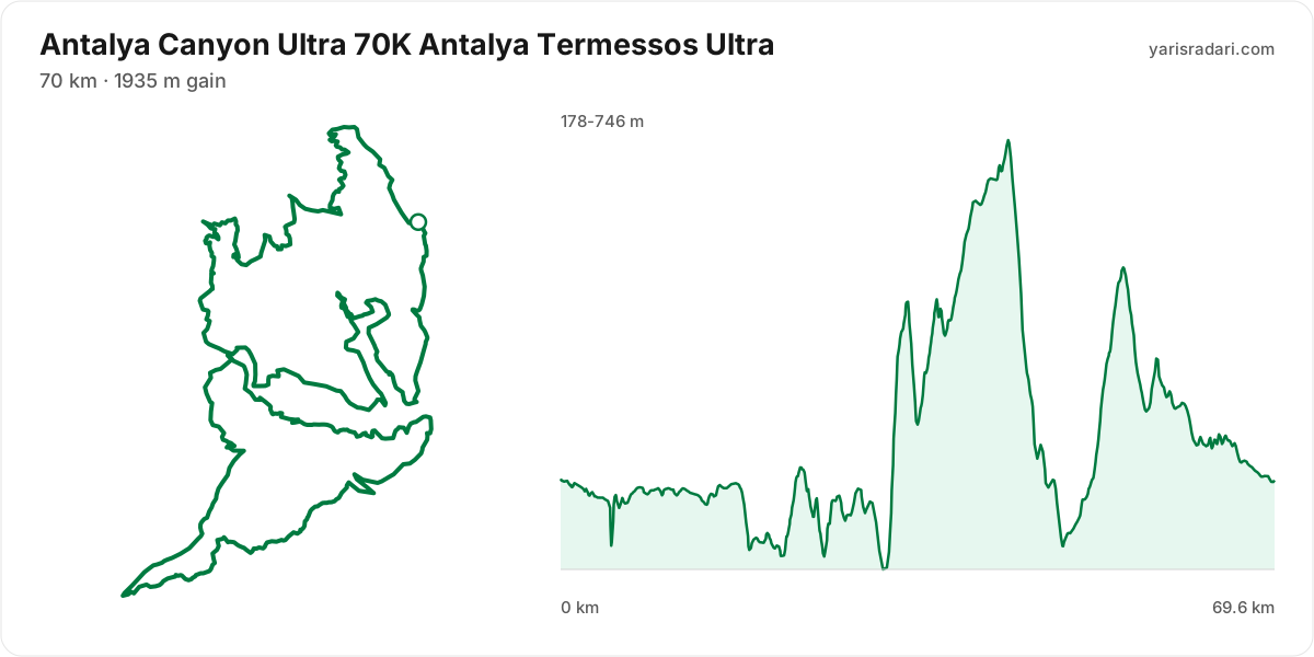
| 70K Antalya Termessos Ultra | 70 km | 1935 m D+ | 89 | 3 | 5,750 ₺ | GPX |
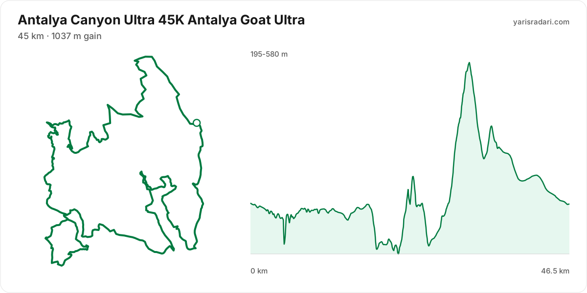
| 45K Antalya Goat Ultra | 45 km | 1037 m D+ | 55 | 2 | 4,850 ₺ | GPX |
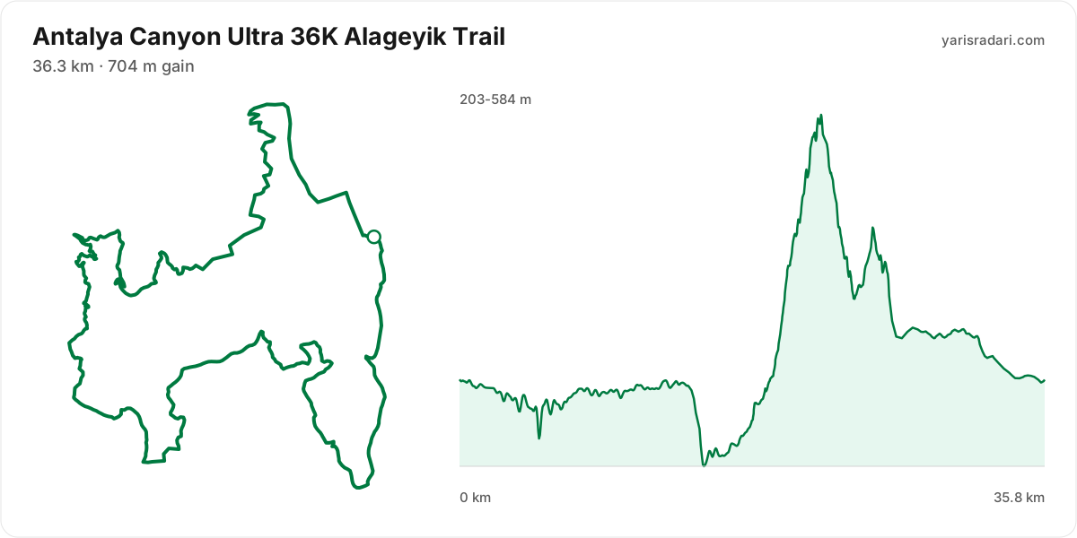
| 36K Alageyik Trail | 36.3 km | 704 m D+ | 43 | 1 | 4,350 ₺ | GPX |
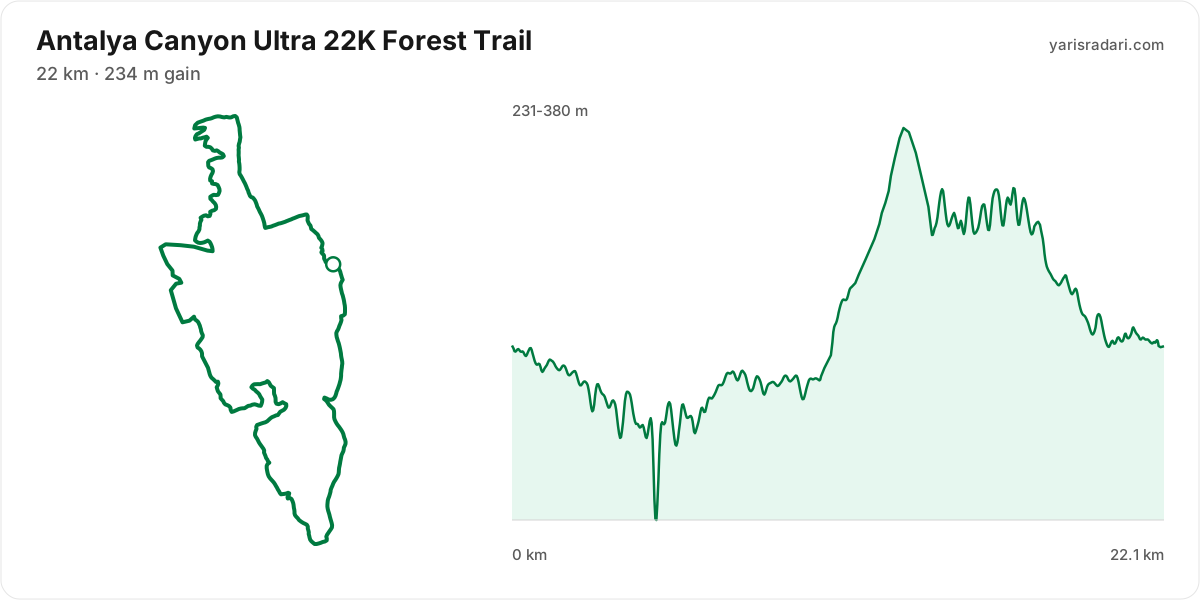
| 22K Forest Trail | 22 km | 234 m D+ | 24 | 1 | 3,750 ₺ | GPX |
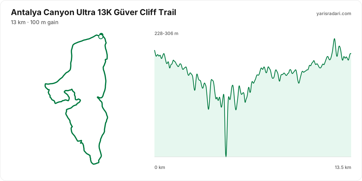
| 13K Güver Cliff Trail | 13 km | 100 m D+ | 14 | 3,200 ₺ | GPX | |
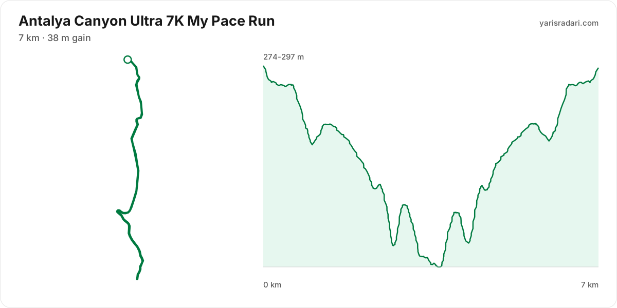
| 7K My Pace Run | 7 km | 38 m D+ | 7 | 2,450 ₺ | GPX |
There are 6 courses: 70K Antalya Termessos Ultra (1935 m D+, 3 ITRA); 45K Antalya Goat Ultra (1037 m D+, 2 ITRA); 36K Alageyik Trail (36.3 km, 704 m D+, 1 ITRA); 22K Forest Trail (234 m D+, 1 ITRA); 13K Güver Cliff Trail (100 m D+); 7K My Pace Run (38 m D+).
Course map and elevation profile
What the weather is usually like here
- Over the last 5 years this week typically ran 9°C to 21°C here, with a high of 24°C and a low of 6°C.
- 14% of those days saw rain. A real forecast lands about two weeks out and will appear here then.
- Typical daily maximum wind was 11 km/h (calm), with 19 km/h the highest value in the sample.
- Sunrise 07:35, sunset 17:48.
The race is more than two weeks out, so these are averages of recent years for the same week, not a forecast. A real forecast appears here closer to the day.
Race briefing
70K Antalya Termessos Ultra course70 km · 1758 m gain · 24% uphill
- Steep climb (10%+)
- Climb (3-10%)
- Flat
- Descent
- Steep descent (12%+)
The published GPX measures 70 km with 1758 m of climbing, 25 m per km. The course sits between 176 m and 747 m of altitude. 46% of the gain sits in the first half.
- 0-32 km: 445 m up / 566 m down; the stretch keeps rolling.
- 32-35 km: 356 m up / 162 m down; the stretch climbs.
- 35-44 km: 442 m up / 66 m down; the stretch climbs.
- 44-49 km: 25 m up / 559 m down; the stretch descends.
- 49-55 km: 366 m up / 3 m down; the stretch climbs.
- 55-70 km: 128 m up / 407 m down; the stretch descends.
The first 5 km drop 62 m. Fresh legs make it feel free, but you climb every metre of it back.
The steepest wall stands between km 32 and km 34: 353 m over 2.1 km at 17% average, its steepest roughly 250 m section averaging 40% on the GPX trace. Kilometre by kilometre: km 33 264 m, km 34 63 m. Running is not on the menu at this grade; settle into a hike from the bottom and load the poles, short steps.
The backbone of the course runs from km 35 to km 44: net 375 m over 8.8 km at 4% average, its steepest roughly 250 m section averaging 12%, 441 m of climbing in total with 66 m given back. Heaviest kilometres: km 36 87 m, km 40 72 m, km 37 71 m, km 39 65 m. This is hiking terrain, not running terrain. Walk it with intent and keep your heart rate off the ceiling.
The late climb from km 49 to km 55: 363 m over 5.9 km at 6% average, its steepest roughly 250 m section averaging 16%. Kilometre by kilometre: km 50 19 m, km 51 36 m, km 52 36 m, km 53 123 m, km 54 91 m, km 55 57 m. By the time you start it, about 72% of the day's climbing is behind you. At this point in the day most runners walk this gradient. Settle into a hiking rhythm and let the metres come.
The longest descent starts at km 44 and loses 534 m by km 49 at 10% average, its steepest roughly 250 m section averaging 24%. Its length can load the quads, so begin under control and build rhythm only when the ground and visibility allow it. The drop at km 34 averages 22% over its steepest roughly 250 m section; shorten the stride, stay balanced and set speed to the ground instead of braking continuously.
The last 6 km drop 45 m. If anything is left in your legs, spend it here.
- The organiser lists 1935 m of climbing; the published GPX measures 1758 m. The technical course notes use the published GPX measurement.
- This course reaches 747 m. At the high-point coordinate, the same week historically ran 8°C to 18°C. Typical daily maximum wind was 10 km/h, reaching 17 km/h in the sample. This is climate history, not the race-day forecast; keep the shell accessible if race week looks similar.
- Sunset is 17:48, 9 hours 48 minutes after the gun. If your target time is longer than that, carry a headtorch whether or not the rules demand one.
- Organiser rule: Runners who start with poles and leave them behind before the finish receive an additional 1-hour time penalty.
- Consider bringing poles. The course averages 25 m of gain per km and the longest climb averaging over 5% runs 5.9 km; if you have trained with them and the organiser allows them, use them on the climbs and stow them on runnable ground.
Course-profile notes are generated from GPX grade data; terrain, rules, aid stations and weather are added only when separately sourced.
45K Antalya Goat Ultra course47 km · 798 m gain · 14% uphill
- Steep climb (10%+)
- Climb (3-10%)
- Flat
- Descent
The published GPX measures 47 km with 798 m of climbing, 17 m per km. The course sits between 195 m and 580 m of altitude. 38% of the gain sits in the first half.
- 0-22 km: 172 m up / 271 m down; gently rolling.
- 22-26 km: 188 m up / 175 m down; the stretch keeps rolling.
- 26-32 km: 360 m up / 0 m down; the stretch climbs.
- 32-47 km: 77 m up / 352 m down; the stretch descends.
The first 3.7 km are close to flat, good for settling in. Do not set your pace here, the real course starts after.
The climb between km 22 and km 24: net 153 m over 2.1 km at 7% average, its steepest roughly 250 m section averaging 14%, 182 m of climbing in total with 29 m given back. Kilometre by kilometre: km 23 100 m, km 24 61 m. This is hiking terrain, not running terrain. Walk it with intent and keep your heart rate off the ceiling.
The backbone of the course runs from km 26 to km 32: 360 m over 5.7 km at 6% average, its steepest roughly 250 m section averaging 17%. Kilometre by kilometre: km 27 18 m, km 28 40 m, km 29 31 m, km 30 122 m, km 31 92 m, km 32 63 m. Trying to run this costs far more than it saves. Shorten the stride, lean on the poles, keep moving.
The longest descent starts at km 24 and loses 140 m by km 26 at 6% average, its steepest roughly 250 m section averaging 15%. Its length can load the quads, so begin under control and build rhythm only when the ground and visibility allow it. The drop at km 32 averages 13% over its steepest roughly 250 m section; shorten the stride, stay balanced and set speed to the ground instead of braking continuously.
The last 5.6 km are close to flat. Plan your finishing pace around that, there is nothing left to save.
- The organiser lists 45 km; the published GPX measures 46.5 km. The organiser lists 1037 m of climbing; the published GPX measures 798 m. The technical course notes use the published GPX measurement.
- Sunset is 17:48, 9 hours 48 minutes after the gun. If your target time is longer than that, carry a headtorch whether or not the rules demand one.
- Organiser rule: Runners who start with poles and leave them behind before the finish receive an additional 1-hour time penalty.
- Consider bringing poles. The course averages 17 m of gain per km and the longest climb averaging over 5% runs 5.7 km; if you have trained with them and the organiser allows them, use them on the climbs and stow them on runnable ground.
- Most of the climbing waits in the second half. Feeling good early is a trap here.
Course-profile notes are generated from GPX grade data; terrain, rules, aid stations and weather are added only when separately sourced.
36K Alageyik Trail course36 km · 636 m gain · 15% uphill
- Steep climb (10%+)
- Climb (3-10%)
- Flat
- Descent
The published GPX measures 36 km with 636 m of climbing, 18 m per km. The course sits between 203 m and 584 m of altitude. 30% of the gain sits in the first half.
- 0-15 km: 135 m up / 226 m down; gently rolling.
- 15-22 km: 391 m up / 19 m down; the stretch climbs.
- 22-36 km: 113 m up / 394 m down; the stretch descends.
The first 2.9 km are close to flat, good for settling in. Do not set your pace here, the real course starts after.
The backbone of the course runs from km 15 to km 22: 372 m over 7 km at 5% average, its steepest roughly 250 m section averaging 16%. Kilometre by kilometre: km 16 16 m, km 18 29 m, km 19 39 m, km 20 108 m, km 21 85 m, km 22 101 m. This is hiking terrain, not running terrain. Walk it with intent and keep your heart rate off the ceiling.
The longest descent starts at km 22 and loses 190 m by km 24 at 9% average, its steepest roughly 250 m section averaging 15%. Its length can load the quads, so begin under control and build rhythm only when the ground and visibility allow it.
The last 4.3 km are close to flat. Plan your finishing pace around that, there is nothing left to save.
- The organiser lists 36.3 km; the published GPX measures 35.8 km. The technical course notes use the published GPX measurement.
- Sunset is 17:48, 9 hours 48 minutes after the gun. If your target time is longer than that, carry a headtorch whether or not the rules demand one.
- Organiser rule: Runners who start with poles and leave them behind before the finish receive an additional 1-hour time penalty.
- Consider bringing poles. The course averages 18 m of gain per km and the longest climb averaging over 5% runs 7 km; if you have trained with them and the organiser allows them, use them on the climbs and stow them on runnable ground.
- Most of the climbing waits in the second half. Feeling good early is a trap here.
Course-profile notes are generated from GPX grade data; terrain, rules, aid stations and weather are added only when separately sourced.
22K Forest Trail course22 km · 296 m gain · 4% uphill
- Climb (3-10%)
- Flat
- Descent
The published GPX measures 22 km with 296 m of climbing, 13 m per km. The course sits between 230 m and 380 m of altitude.
The first 1.8 km are close to flat, good for settling in. Do not set your pace here, the real course starts after.
The last 2.7 km are close to flat. Plan your finishing pace around that, there is nothing left to save.
- Sunset is 17:48, 9 hours 48 minutes after the gun. If your target time is longer than that, carry a headtorch whether or not the rules demand one.
- The profile does not show a clear need for poles: 13 m of gain per km. If you are not used to them, running with your hands free may be more comfortable.
Course-profile notes are generated from GPX grade data; terrain, rules, aid stations and weather are added only when separately sourced.
13K Güver Cliff Trail course13 km · 147 m gain · 0% uphill
- Flat
The published GPX measures 13 km with 147 m of climbing, 11 m per km. The course sits between 228 m and 306 m of altitude.
The first 1.5 km are close to flat, good for settling in. Do not set your pace here, the real course starts after.
The last 2 km are close to flat. Plan your finishing pace around that, there is nothing left to save.
- Sunset is 17:48, 9 hours 48 minutes after the gun. If your target time is longer than that, carry a headtorch whether or not the rules demand one.
- Organiser rule: Runners who start with poles and leave them anywhere before the finish receive an additional 1-hour time penalty.
- The profile does not show a clear need for poles: 11 m of gain per km. If you are not used to them, running with your hands free may be more comfortable.
Course-profile notes are generated from GPX grade data; terrain, rules, aid stations and weather are added only when separately sourced.
7K My Pace Run course7 km · 25 m gain · 0% uphill
- Flat
The published GPX measures 7 km with 25 m of climbing, 4 m per km.
The first 1.5 km are close to flat, good for settling in. Do not set your pace here, the real course starts after.
The last 2 km are close to flat. Plan your finishing pace around that, there is nothing left to save.
- Sunset is 17:48, 9 hours 48 minutes after the gun. If your target time is longer than that, carry a headtorch whether or not the rules demand one.
- Out and back: you turn at km 3.5 and return the same way. Note how easy the outward leg felt, you pay for it in reverse.
Course-profile notes are generated from GPX grade data; terrain, rules, aid stations and weather are added only when separately sourced.
Calculators for this race
Registration
- StandardSat, Aug 1, 2026 - Thu, Sep 24, 20261,650 ₺Ended
- Late RegistrationFri, Sep 25, 2026 - Sun, Oct 25, 20261,650 ₺Registration open
Data sources: PassTiming race calendar, official site (antalyacanyontrail.com) · Last checked:
Organising this race? See how to correct details and complete this page
Similar races
Frequently asked questions
(31)
What is Antalya Canyon Ultra?
Antalya Canyon Ultra is a first-edition trail event run through the canyons of the Taurus Mountains. The courses around Güver Cliff are run over five distances ranging from 7 km to 70 km; registration may close before the quota is filled.
When is Antalya Canyon Ultra 2026?
Antalya Canyon Ultra takes place on Fri, Nov 13, 2026 - Sun, Nov 15, 2026. Start time: 08:00.
Where does Antalya Canyon Ultra take place?
Antalya Canyon Ultra takes place in Antalya.
What are the courses and distances of Antalya Canyon Ultra 2026?
Antalya Canyon Ultra offers 6 courses: 70K Antalya Termessos Ultra (70 km, 1935 m D+, 3 ITRA); 45K Antalya Goat Ultra (45 km, 1037 m D+, 2 ITRA); 36K Alageyik Trail (36.3 km, 704 m D+, 1 ITRA); 22K Forest Trail (22 km, 234 m D+, 1 ITRA); 13K Güver Cliff Trail (13 km, 100 m D+); 7K My Pace Run (7 km, 38 m D+).
How hard is Antalya Canyon Ultra 2026?
Difficulty is measured in km-effort: distance plus ascent divided by 100. The 70K Antalya Termessos Ultra course covers 70 km with 1935 m of climbing, which is 89 km-effort and falls in ITRA category M. All courses: 70K Antalya Termessos Ultra 89 km-effort (M), 45K Antalya Goat Ultra 55 km-effort (S), 36K Alageyik Trail 43 km-effort (XS), 22K Forest Trail 24 km-effort (XXS), 13K Güver Cliff Trail 14 km-effort (XXS), 7K My Pace Run 7 km-effort (XXS).
Is registration for Antalya Canyon Ultra 2026 open?
Registration appears to be open; the deadline is Sun, Oct 25, 2026.
When is the registration deadline for Antalya Canyon Ultra 2026?
The registration deadline for Antalya Canyon Ultra is Sun, Oct 25, 2026.
How much does Antalya Canyon Ultra 2026 cost?
The known registration fee for Antalya Canyon Ultra is from 2,450 ₺. Fees may change by registration period.
What is the official website of Antalya Canyon Ultra?
Official website: https://www.antalyacanyontrail.com/
Is a medical certificate required for Antalya Canyon Ultra?
The requirement does not apply to everyone. See the organiser's official page for the exact wording.
Is the Antalya Canyon Ultra 2026 course a loop or an out and back?
The 70K Antalya Termessos Ultra course is a single loop with a shared start and finish; measured from the GPX file it runs 69.6 km. The 45K Antalya Goat Ultra course is a single loop with a shared start and finish; measured from the GPX file it runs 46.5 km. The 36K Alageyik Trail course is a single loop with a shared start and finish; measured from the GPX file it runs 35.8 km.
Where is the hardest climb at Antalya Canyon Ultra 2026?
The biggest climb on the 70K Antalya Termessos Ultra course runs from km 35 to km 44: 8.8 km for 375 m at 4% average; its steepest roughly 250 m section averages 12%. It tops out at 746 m.
How high does Antalya Canyon Ultra 2026 go?
The 70K Antalya Termessos Ultra course runs between 176 m and 747 m with 1758 m of total climbing.
Do you need poles at Antalya Canyon Ultra 2026?
The 70K Antalya Termessos Ultra course averages 25 m of gain per km with a longest climb of 5.9 km, so poles help noticeably.
Do you need a headtorch at Antalya Canyon Ultra 2026?
70K Antalya Termessos Ultra: Sunset is 17:48, 9 hours 48 minutes after the gun. If your target time is longer than that, carry a headtorch whether or not the rules demand one.
What is the weather like at Antalya Canyon Ultra 2026?
Over the last 5 years the same week here measured 9°C to 21°C, with a high of 24°C, a low of 6°C and rain on 14% of days. A real forecast lands about two weeks out.
What time does Antalya Canyon Ultra 2026 start?
Known start times: 70K Antalya Termessos Ultra 08:00, 45K Antalya Goat Ultra 08:00, 36K Alageyik Trail 08:00, 22K Forest Trail 08:00, 13K Güver Cliff Trail 08:00, 7K My Pace Run 08:00, local time. Confirm against the organiser's schedule in race week.
Is there a GPX file for Antalya Canyon Ultra 2026?
Yes. The GPX files for the 70K Antalya Termessos Ultra, 45K Antalya Goat Ultra, 36K Alageyik Trail, 22K Forest Trail, 13K Güver Cliff Trail, 7K My Pace Run courses can be downloaded from the course section on this page, next to the route and grade profile.
Which Antalya Canyon Ultra course should you choose?
The shortest option is 7K My Pace Run (7 km, 38 m D+) and the longest is 70K Antalya Termessos Ultra (70 km, 1935 m D+). With little trail experience the 7K My Pace Run is the safer start; the 70K Antalya Termessos Ultra demands an all-day effort and cut-off management.
What are the gradients like at Antalya Canyon Ultra 2026?
The 70K Antalya Termessos Ultra course averages 25 m of climbing per km, with 1758 m of total ascent and 1759 m of descent. The steepest kilometre averages 26%.
How runnable is the Antalya Canyon Ultra 2026 course?
Expect a mix of running and power hiking: 25 m of gain per km; hiking the long climbs is normal, and the longest climb runs 8.8 km.
Where is the steepest part of Antalya Canyon Ultra 2026?
The steepest kilometre of the 70K Antalya Termessos Ultra course averages 26% and sits inside the climb between km 32 and km 34.
How many climbs does Antalya Canyon Ultra 2026 have?
The 70K Antalya Termessos Ultra course has 6 distinct climbs. The biggest: km 35-44 (375 m at 4%); km 49-55 (363 m at 6%); km 32-34 (353 m at 17%).
Is there a long climb at Antalya Canyon Ultra 2026?
Yes. The longest climb runs 8.8 km from km 35, gaining 375 m at 4% average, topping out at 746 m.
What are the descents like at Antalya Canyon Ultra 2026?
There is 1759 m of descent in total. The longest drop runs 5.2 km between km 44 and km 49, losing 534 m.
Are there flat sections at Antalya Canyon Ultra 2026?
Yes, roughly 58% of the course is near flat, with long sections where a rhythm holds.
Is the hard part of Antalya Canyon Ultra 2026 early or late?
The climbing is evenly split: 46% of it sits in the first half.
What is the elevation range at Antalya Canyon Ultra 2026?
The lowest point of the 70K Antalya Termessos Ultra course sits at 176 m and the highest at 747 m, a range of 571 m.
Where does Antalya Canyon Ultra 2026 reach its high point?
The course tops out at 747 m, reached around km 44.
Are poles mandatory at Antalya Canyon Ultra 2026?
The organiser's rule: Runners who start with poles and leave them behind before the finish receive an additional 1-hour time penalty.
How many ITRA points does Antalya Canyon Ultra 2026 give?
ITRA points: 70K Antalya Termessos Ultra 3 ITRA, 45K Antalya Goat Ultra 2 ITRA, 36K Alageyik Trail 1 ITRA, 22K Forest Trail 1 ITRA. These points count towards entry requirements for UTMB style races.