Latmos Ultra MaratonuMuğla🇹🇷
About Latmos Ultra Maratonu 2026
Latmos Ultra Maratonu 2026 is a trail race held on Sat, Nov 14, 2026 in Muğla; the start is at 08:00.
Registration is open; the deadline is Tue, Nov 10, 2026. The entry fee is from 2,310 ₺. Dates, registration windows and fees on this page are refreshed every morning by scanning federation, timing and organiser sites; registration always happens on the official race site.
Someone running 30 km a week needs 17 weeks, about 4 months, to prepare for the 45K course of Latmos Ultra Maratonu 2026; that start day was Sat, Jul 18, 2026, so the window has passed with 4 weeks left to the race.
The Latmos Ultra Marathon will be organized on 14 November around the Beşparmak Mountains, located along the border of the provinces of Aydın/Muğla, under the auspices of the Muğla Metropolitan Municipality. The Latmos Ultra Marathon consists of four (4) stages: Latmos Lake Trail 10K, Latmos Short Trail 17Km, Latmos Medium Trail 26Km and Latmos Ultra Marathon 45Km.
Courses
| Course | Distance | Elevation Gain | Km-effort | Fee | Course file |
|---|---|---|---|---|---|
| 45K | 45 km | 2161 m D+ | 67 | 4,510 ₺ | GPX |
| 26K | 26 km | 1378 m D+ | 40 | 4,010 ₺ | GPX |
| 17K | 17 km | 1313 m D+ | 30 | 3,410 ₺ | GPX |
| 8K | 8 km | 77 m D+ | 9 | 2,310 ₺ | GPX |
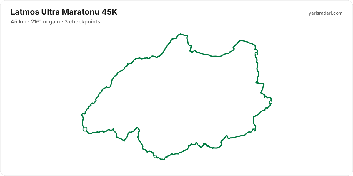
There are 4 courses: 45K (2161 m D+); 26K (1378 m D+); 17K (1313 m D+); 8K (77 m D+).
Course map and elevation profile
What the weather is usually like here
- Over the last 5 years this week typically ran 11°C to 21°C here, with a high of 25°C and a low of 7°C.
- 23% of those days saw rain. A real forecast lands about two weeks out and will appear here then.
- Typical daily maximum wind was 13 km/h (a light breeze), with 27 km/h the highest value in the sample.
- Sunrise 07:48, sunset 18:00.
The race is more than two weeks out, so these are averages of recent years for the same week, not a forecast. A real forecast appears here closer to the day.
Race briefing
45K course41 km · 2161 m gain · 3 aid stations
- The organiser lists 45 km; the published GPX measures 40.9 km. The course notes use the GPX for route shape and the aid-station table for climbing.
- Start 07:00, sunrise 07:48: the first 48 minutes are run in the dark. The headtorch goes on your head at the start, not in your pack.
- Sunset is 18:00, 11 hours after the gun. If your target time is longer than that, carry a headtorch whether or not the rules demand one.
- The file measures 40.9 km against the advertised 45 km, so expect your watch to disagree with the signs.
The organiser's GPX file has no elevation data, so the grade profile and kilometre analysis cannot be shown for this course; the climb figure is the one the organiser advertises.
Aid stations
- The longest stretch between official aid stations runs from CP3 (km 33) to Finish (km 45): 12 km. Top up at CP3 and size what you carry to the expected duration and your own drinking rate.
| Station | Km | From previous |
|---|---|---|
| CP1 | 18 | 18 |
| CP2 | 22 | 4.5 |
| CP3 | 33 | 11 |
| Finish | 45 | 12 |
Aid station details come from the list published by the organiser; confirm them at the official source before race day.
Plan your cutoffs for this course
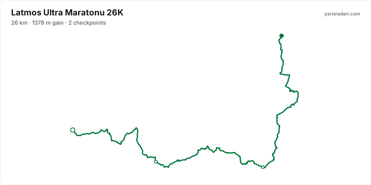
26K course25 km · 1378 m gain · 2 aid stations
- The organiser lists 26 km; the published GPX measures 25.1 km. The course notes use the GPX for route shape and the aid-station table for climbing.
- Sunset is 17:59, 9 hours 59 minutes after the gun. If your target time is longer than that, carry a headtorch whether or not the rules demand one.
- Point to point: the finish sits 10.6 km from the start as the crow flies. Sort the shuttle and your drop bag before race day.
- The file measures 25.1 km against the advertised 26 km, so expect your watch to disagree with the signs.
The organiser's GPX file has no elevation data, so the grade profile and kilometre analysis cannot be shown for this course; the climb figure is the one the organiser advertises.
Aid stations
- The longest gap between official aid stations is 9 km, from CP2 (km 18) to Finish Kapıkırı (km 26). Split your fluid accordingly.
| Station | Km | From previous |
|---|---|---|
| CP1 | 9.8 | 9.8 |
| CP2 | 18 | 7.7 |
| Finish Kapıkırı | 26 | 8.5 |
Aid station details come from the list published by the organiser; confirm them at the official source before race day.
Plan your cutoffs for this course
17K course18 km · 1295 m gain · 55% uphill
- Steep climb (10%+)
- Climb (3-10%)
- Flat
- Descent
- Steep descent (12%+)
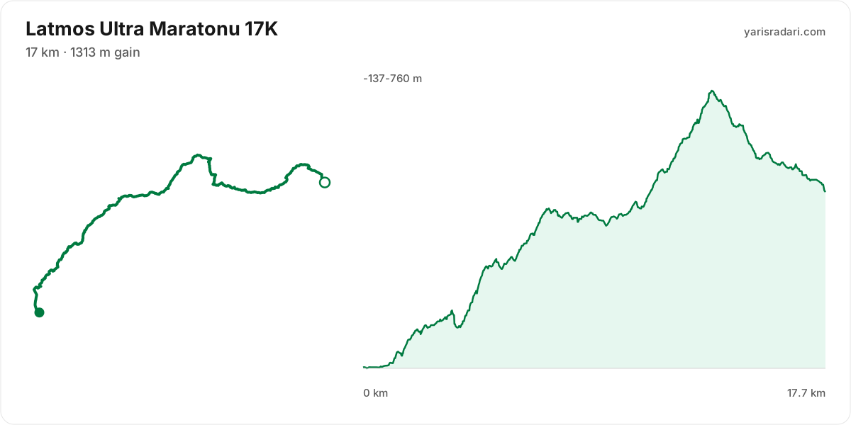
The published GPX measures 18 km with 1295 m of climbing, 73 m per km. The course sits between -137 m and 760 m of altitude. 57% of the gain sits in the first half.
The race climbs from the gun: 57 m over the first 1.5 km. Do not chase the crowd, the two minutes you win here get taken back with interest.
The backbone of the course runs from km 1 to km 13: net 891 m over 13 km at 7% average, its steepest roughly 250 m section averaging 24%, 1222 m of climbing in total with 331 m given back. Heaviest kilometres: km 5 170 m, km 13 140 m, km 12 139 m, km 7 132 m. This is hiking terrain, not running terrain. Walk it with intent and keep your heart rate off the ceiling.
The longest descent starts at km 13 and loses 327 m by km 18 at 8% average, its steepest roughly 250 m section averaging 19%. Its length can load the quads, so begin under control and build rhythm only when the ground and visibility allow it.
The last 2.1 km drop 110 m. If anything is left in your legs, spend it here.
- The organiser lists 17 km; the published GPX measures 17.7 km. The technical course notes use the published GPX measurement.
- This course reaches 760 m. At the high-point coordinate, the same week historically ran 9°C to 15°C. Typical daily maximum wind was 14 km/h, reaching 28 km/h in the sample. This is climate history, not the race-day forecast; keep the shell accessible if race week looks similar.
- Start 07:00, sunrise 07:48: the first 48 minutes are run in the dark. The headtorch goes on your head at the start, not in your pack.
- Sunset is 18:00, 11 hours after the gun. If your target time is longer than that, carry a headtorch whether or not the rules demand one.
- Poles are strongly recommended for this profile. The course averages 73 m of gain per km and the longest climb averaging over 5% runs 13 km; if you have trained with them and the organiser allows them, use them on the climbs and stow them on runnable ground.
- Point to point: the finish sits 10.6 km from the start as the crow flies. Sort the shuttle and your drop bag before race day.
Course-profile notes are generated from GPX grade data; terrain, rules, aid stations and weather are added only when separately sourced.
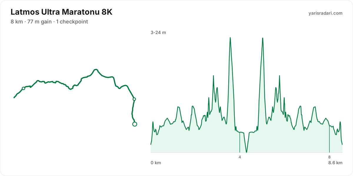
8K course9 km · 62 m gain · 0% uphill · 1 aid station
- Flat
The published GPX measures 8.6 km with 62 m of climbing, 7 m per km.
The first 1.5 km are close to flat, good for settling in. Do not set your pace here, the real course starts after.
The last 2 km are close to flat. Plan your finishing pace around that, there is nothing left to save.
- The organiser lists 8 km; the published GPX measures 8.6 km. The technical course notes use the published GPX measurement.
- Sunset is 18:00, 2 hours 30 minutes after the gun. If your target time is longer than that, carry a headtorch whether or not the rules demand one.
- Out and back: you turn at km 4.3 and return the same way. Note how easy the outward leg felt, you pay for it in reverse.
- Km 4.6 to 8.6 is the same ground you covered at km 4; note your pace on the first pass and use it as the yardstick on the second.
Course-profile notes are generated from GPX grade data; terrain, rules, aid stations and weather are added only when separately sourced.
Aid stations
| Station | Km | From previous |
|---|---|---|
| CP1 | 4 | 4 |
| CP2 Kapıkırı Meydan | 8 | 4 |
Aid station details come from the list published by the organiser; confirm them at the official source before race day.
Plan your cutoffs for this course
Calculators for this race
Registration
- StandardMon, Feb 2, 2026 - Sat, Oct 17, 20262,310 ₺Registration open
- Late RegistrationSun, Oct 18, 2026 - Tue, Nov 10, 20262,710 ₺Not open yet
- Early BirdSun, Feb 1, 20261,510 ₺Ended
Data sources: PassTiming race calendar, TAF private road races, official site (latmosultra.org) · Last checked:
Organising this race? See how to correct details and complete this page
Similar races
Frequently asked questions
(33)
What is Latmos Ultra Maratonu?
The Latmos Ultra Marathon will be organized on 14 November around the Beşparmak Mountains, located along the border of the provinces of Aydın/Muğla, under the auspices of the Muğla Metropolitan Municipality. The Latmos Ultra Marathon consists of four (4) stages: Latmos Lake Trail 10K, Latmos Short Trail 17Km, Latmos Medium Trail 26Km and Latmos Ultra Marathon 45Km.
When is Latmos Ultra Maratonu 2026?
Latmos Ultra Maratonu takes place on Sat, Nov 14, 2026. Start time: 08:00.
Where does Latmos Ultra Maratonu take place?
Latmos Ultra Maratonu takes place in Muğla.
What are the courses and distances of Latmos Ultra Maratonu 2026?
Latmos Ultra Maratonu offers 4 courses: 45K (45 km, 2161 m D+); 26K (26 km, 1378 m D+); 17K (17 km, 1313 m D+); 8K (8 km, 77 m D+).
How hard is Latmos Ultra Maratonu 2026?
Difficulty is measured in km-effort: distance plus ascent divided by 100. The 45K course covers 45 km with 2161 m of climbing, which is 67 km-effort and falls in ITRA category S. All courses: 45K 67 km-effort (S), 26K 40 km-effort (XS), 17K 30 km-effort (XS), 8K 9 km-effort (XXS).
Is registration for Latmos Ultra Maratonu 2026 open?
Registration appears to be open; the deadline is Tue, Nov 10, 2026.
When is the registration deadline for Latmos Ultra Maratonu 2026?
The registration deadline for Latmos Ultra Maratonu is Tue, Nov 10, 2026.
How much does Latmos Ultra Maratonu 2026 cost?
The known registration fee for Latmos Ultra Maratonu is from 2,310 ₺. Fees may change by registration period.
Where are the Latmos Ultra Maratonu photos?
Latmos Ultra Maratonu photos are in the organiser's gallery: https://www.latmosultra.org/fotograflar/. The gallery may also cover earlier editions.
What is the official website of Latmos Ultra Maratonu?
Official website: http://www.latmosultra.org/
Is a medical certificate required for Latmos Ultra Maratonu?
The requirement does not apply to everyone. See the organiser's official page for the exact wording.
Is the Latmos Ultra Maratonu 2026 course a loop or an out and back?
The 45K course is a single loop with a shared start and finish; measured from the GPX file it runs 40.9 km. The 26K course is point to point, finishing 10.6 km from the start; measured from the GPX file it runs 25.1 km. The 17K course is point to point, finishing 10.6 km from the start; measured from the GPX file it runs 17.7 km.
Where is the hardest climb at Latmos Ultra Maratonu 2026?
The biggest climb on the 17K course runs from km 1 to km 13: 12.6 km for 891 m at 7% average; its steepest roughly 250 m section averages 24%. It tops out at 759 m.
How high does Latmos Ultra Maratonu 2026 go?
The 17K course runs between -137 m and 760 m with 1295 m of total climbing.
Do you need poles at Latmos Ultra Maratonu 2026?
The 17K course averages 73 m of gain per km with a longest climb of 12.6 km, so poles help noticeably.
Do you need a headtorch at Latmos Ultra Maratonu 2026?
45K: Start 07:00, sunrise 07:48: the first 48 minutes are run in the dark. The headtorch goes on your head at the start, not in your pack. Sunset is 18:00, 11 hours after the gun. If your target time is longer than that, carry a headtorch whether or not the rules demand one.
What is the weather like at Latmos Ultra Maratonu 2026?
Over the last 5 years the same week here measured 11°C to 21°C, with a high of 25°C, a low of 7°C and rain on 23% of days. A real forecast lands about two weeks out.
Where are the aid stations at Latmos Ultra Maratonu 2026?
The 45K course has 3 stations; the first at km 18 and the last at km 33. The longest gap between them is 11 km, between CP2 and CP3.
What time does Latmos Ultra Maratonu 2026 start?
Known start times: 45K 07:00, 26K 08:00, 17K 07:00, 8K 15:30, local time. Confirm against the organiser's schedule in race week.
Is there a GPX file for Latmos Ultra Maratonu 2026?
Yes. The GPX files for the 45K, 26K, 17K, 8K courses can be downloaded from the course section on this page, next to the route map. Where the organiser's GPX file has no elevation data, there is no grade profile.
Which Latmos Ultra Maratonu course should you choose?
The shortest option is 8K (8 km, 77 m D+) and the longest is 45K (45 km, 2161 m D+). With little trail experience the 8K is the safer start; the 45K demands an all-day effort and cut-off management.
What are the gradients like at Latmos Ultra Maratonu 2026?
The 17K course averages 73 m of climbing per km, with 1295 m of total ascent and 732 m of descent. The steepest kilometre averages 18%.
How runnable is the Latmos Ultra Maratonu 2026 course?
This is not a running course in the classic sense: at 73 m of gain per km it demands long hiking blocks, and walking the steep climbs is part of the strategy.
Where is the steepest part of Latmos Ultra Maratonu 2026?
The steepest kilometre of the 17K course averages 18% and sits inside the climb between km 1 and km 13.
How many climbs does Latmos Ultra Maratonu 2026 have?
The 17K course has 1 distinct climb. It runs: km 1-13 (891 m at 7%).
Is there a long climb at Latmos Ultra Maratonu 2026?
Yes. The longest climb runs 12.6 km from km 1, gaining 891 m at 7% average, topping out at 759 m.
What are the descents like at Latmos Ultra Maratonu 2026?
There is 732 m of descent in total. The longest drop runs 4.3 km between km 13 and km 18, losing 327 m.
Are there flat sections at Latmos Ultra Maratonu 2026?
Partly: about 22% of the course is near flat, the rest climbs or descends.
Is the hard part of Latmos Ultra Maratonu 2026 early or late?
The climbing is evenly split: 57% of it sits in the first half.
What is the elevation range at Latmos Ultra Maratonu 2026?
The lowest point of the 17K course sits at -137 m and the highest at 760 m, a range of 897 m.
Where does Latmos Ultra Maratonu 2026 reach its high point?
The course tops out at 760 m, reached around km 13.
Are poles mandatory at Latmos Ultra Maratonu 2026?
The organiser has not announced a pole requirement. Based on the profile poles help noticeably.
Do you need to carry water at Latmos Ultra Maratonu 2026?
Yes: the longest stretch without aid on the 45K course is 17.5 km, so carrying backup water is essential.