Uludağ Ultra TrailBursa🇹🇷
Completed
About Uludağ Ultra Trail 2026
Uludağ Ultra Trail 2026 was a trail race held from Sat, Jul 18, 2026 to Sun, Jul 19, 2026 in Bursa; the start is at 06:00.
The 2026 edition is over; registration is closed. The next edition, Uludağ Ultra Trail, is on Fri, Jul 16, 2027.
A mountain running event in the summit area of Uludağ, starting and finishing in the Hotels Area (Oteller Bölgesi). The 6K, 16K, 30K, 42K (44 km) and 70K (73 km) courses are spread over two days; most of the routes run above 2,000 metres altitude, predominantly on trails and single track.
Courses
| Course | Distance | Elevation Gain | Km-effort | Course file |
|---|---|---|---|---|
| 70K | 73 km | 3661 m D+ | 110 | GPX |
| 42K | 44 km | 2353 m D+ | 68 | GPX |
| 30K | 30 km | 1510 m D+ | 45 | GPX |
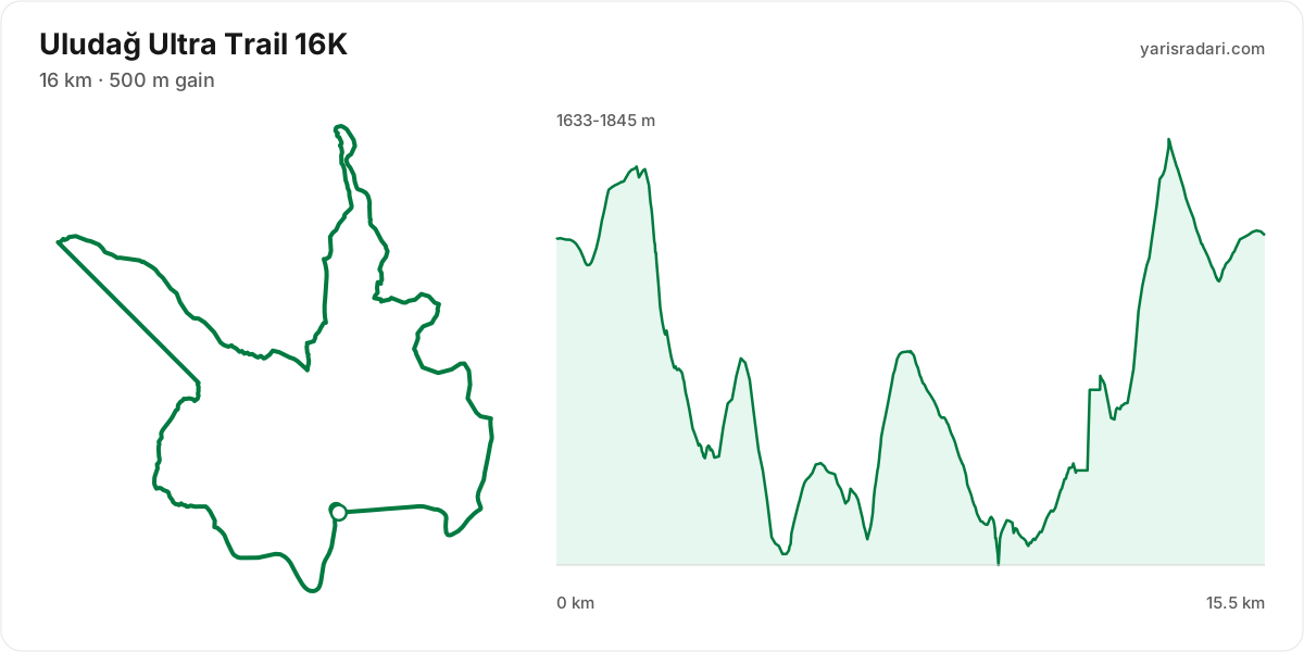
| 16K | 16 km | 500 m D+ | 21 | GPX |
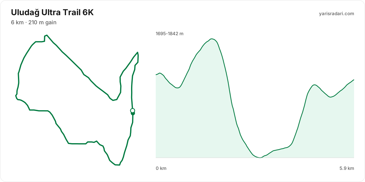
| 6K | 6 km | 210 m D+ | 8 | GPX |
There are 5 courses: 70K (73 km, 3661 m D+); 42K (44 km, 2353 m D+); 30K (1510 m D+); 16K (500 m D+); 6K (210 m D+).
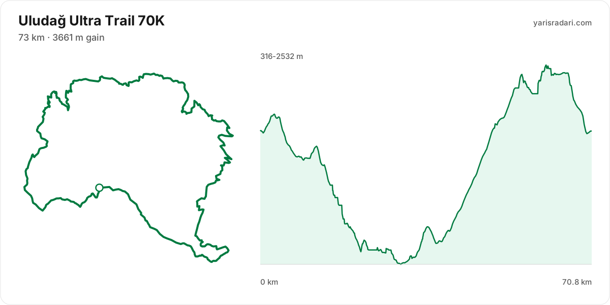
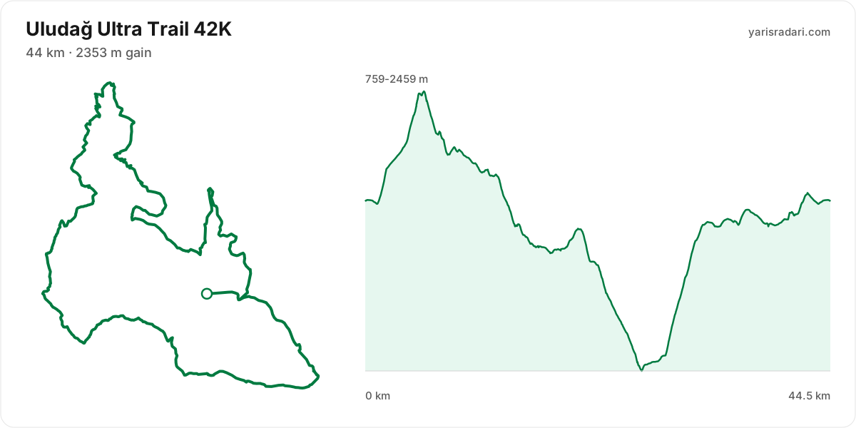
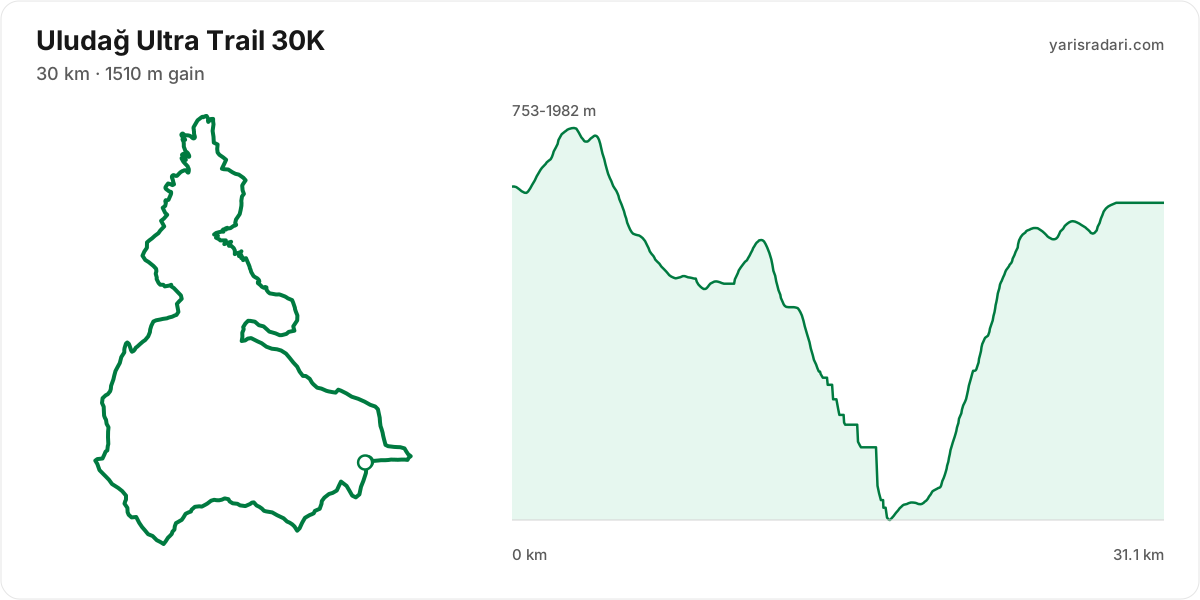
Course map and elevation profile
What the weather was on race day
- On race day the temperature ran 10°C to 22°C, and the day stayed dry, peak wind 12 km/h (a light breeze).
- These figures come from the measurement archive after the race, not from a forecast.
- Sunrise 05:49, sunset 20:29.
The race is over. These figures come from the Open-Meteo measurement archive for that day, not from a forecast.
Race briefing
70K course71 km · 3401 m gain · 35% uphill
- Steep climb (10%+)
- Climb (3-10%)
- Flat
- Descent
- Steep descent (12%+)
The published GPX measures 71 km with 3401 m of climbing, 48 m per km. The course sits between 316 m and 2533 m of altitude. 31% of the gain sits in the first half.
- 0-12 km: 387 m up / 565 m down; the stretch descends.
- 12-30 km: 235 m up / 1532 m down; the stretch descends.
- 30-38 km: 441 m up / 212 m down; the stretch climbs.
- 38-56 km: 1901 m up / 25 m down; the stretch climbs.
- 56-61 km: 320 m up / 233 m down; the stretch climbs.
- 61-71 km: 120 m up / 837 m down; the stretch descends.
The first 5 km climb 224 m and then drop 238 m. Do not attack the opening climb in the crowd, and do not brake your way down the drop behind it.
The climb between km 30 and km 36: 413 m over 5.6 km at 7% average, its steepest roughly 250 m section averaging 21%. Kilometre by kilometre: km 31 17 m, km 32 62 m, km 33 23 m, km 34 87 m, km 35 190 m, km 36 62 m. This is hiking terrain, not running terrain. Walk it with intent and keep your heart rate off the ceiling.
The backbone of the course runs from km 38 to km 56: 1876 m over 18 km at 10% average, its steepest roughly 250 m section averaging 51% on the GPX trace. It tops out at 2427 m. Heaviest kilometres: km 56 153 m, km 54 147 m, km 49 144 m, km 47 143 m. Running is off the table only in the steepest roughly 250 m core; hike that part with short steps and run again once the grade eases.
The longest descent starts at km 12 and loses 1298 m by km 30 at 7% average, its steepest roughly 250 m section averaging 37% on the GPX trace. Its length can load the quads, so begin under control and build rhythm only when the ground and visibility allow it. The drop at km 61 averages 32% on the GPX trace over its steepest roughly 250 m section; shorten the stride, stay balanced and set speed to the ground instead of braking continuously.
The last 6 km drop 672 m. If anything is left in your legs, spend it here.
- The organiser lists 73 km; the published GPX measures 70.8 km. The organiser lists 3661 m of climbing; the published GPX measures 3401 m. The technical course notes use the published GPX measurement.
- This course reaches 2533 m. A separate forecast for the high-point coordinate gives 6°C to 17°C, wind up to 12 km/h (a light breeze). It is a daily forecast for that coordinate, so arrival time can still change what you encounter.
- Sunset is 20:29, 14 hours 29 minutes after the gun. If your target time is longer than that, carry a headtorch whether or not the rules demand one.
- Poles are strongly recommended for this profile. The course averages 48 m of gain per km and the longest climb averaging over 5% runs 18 km; if you have trained with them and the organiser allows them, use them on the climbs and stow them on runnable ground.
- Most of the climbing waits in the second half. Feeling good early is a trap here.
- 18% of the course is steep descent. Increase your cadence instead of braking, or your quads go early.
- Arrive early for the altitude. The course tops out at 2533 m, and coming up from sea level on race morning costs you more than any training block gains. Get to the area a few days ahead and let your body adjust.
- The altitude is not a single summit: about 24 km of the course sits above 1800 m, 6.4 km above 2400 m. The longest unbroken stretch up high is 20 km and the high zone spans roughly km 50 to km 70.
Course-profile notes are generated from GPX grade data; terrain, rules, aid stations and weather are added only when separately sourced.
42K course45 km · 2325 m gain · 39% uphill
- Steep climb (10%+)
- Climb (3-10%)
- Flat
- Descent
- Steep descent (12%+)
The published GPX measures 45 km with 2325 m of climbing, 52 m per km. The course sits between 759 m and 2459 m of altitude. 44% of the gain sits in the first half.
- 0-5.6 km: 703 m up / 35 m down; the stretch climbs.
- 5.6-18 km: 152 m up / 1136 m down; the stretch descends.
- 18-20 km: 157 m up / 11 m down; the stretch climbs.
- 20-26 km: 4 m up / 858 m down; the stretch descends.
- 26-42 km: 1280 m up / 210 m down; the stretch climbs.
- 42-45 km: 28 m up / 74 m down; gently rolling.
The race climbs from the gun: 329 m over the first 3.6 km. Do not chase the crowd, the two minutes you win here get taken back with interest.
The steepest wall stands between km 0 and km 6: 669 m over 5.6 km at 12% average, its steepest roughly 250 m section averaging 33% on the GPX trace. It tops out at 2459 m. Kilometre by kilometre: km 2 203 m, km 3 82 m, km 4 101 m, km 5 242 m, km 6 72 m. Running is off the table only in the steepest roughly 250 m core; hike that part with short steps and run again once the grade eases.
The backbone of the course runs from km 26 to km 42: net 1070 m over 16 km at 7% average, its steepest roughly 250 m section averaging 31% on the GPX trace, 1280 m of climbing in total with 210 m given back. It tops out at 1836 m. Heaviest kilometres: km 30 258 m, km 31 221 m, km 32 198 m, km 29 106 m. This is hiking terrain, not running terrain. Walk it with intent and keep your heart rate off the ceiling.
The longest descent starts at km 6 and loses 984 m by km 18 at 8% average, its steepest roughly 250 m section averaging 23%. Its length can load the quads, so begin under control and build rhythm only when the ground and visibility allow it. The drop at km 20 averages 28% over its steepest roughly 250 m section; shorten the stride, stay balanced and set speed to the ground instead of braking continuously.
The last 5.3 km climb 191 m to the line. Know it going in and save something for it.
- The elevation for this course comes from the route the organiser published on Strava, because the GPX file on their own site carries no elevation. Strava derives those figures from a terrain model, so they are an estimate rather than a recorded measurement.
- The organiser lists 44 km; the published GPX measures 44.5 km. The technical course notes use the published GPX measurement.
- This course reaches 2459 m. A separate forecast for the high-point coordinate gives 7°C to 18°C, wind up to 12 km/h (a light breeze). It is a daily forecast for that coordinate, so arrival time can still change what you encounter.
- Poles are strongly recommended for this profile. The course averages 52 m of gain per km and the longest climb averaging over 5% runs 16 km; if you have trained with them and the organiser allows them, use them on the climbs and stow them on runnable ground.
- 21% of the course is steep descent. Increase your cadence instead of braking, or your quads go early.
- Arrive early for the altitude. The course tops out at 2459 m, and coming up from sea level on race morning costs you more than any training block gains. Get to the area a few days ahead and let your body adjust.
- The altitude is not a single summit: about 13 km of the course sits above 1800 m. The longest unbroken stretch up high is 12 km and the high zone spans roughly km 1 to km 14.
Course-profile notes are generated from GPX grade data; terrain, rules, aid stations and weather are added only when separately sourced.
30K course31 km · 1436 m gain · 31% uphill
- Steep climb (10%+)
- Climb (3-10%)
- Flat
- Descent
- Steep descent (12%+)
The published GPX measures 31 km with 1436 m of climbing, 46 m per km. The course sits between 753 m and 1982 m of altitude. 26% of the gain sits in the first half.
- 0-3.1 km: 199 m up / 18 m down; the stretch climbs.
- 3.1-9.3 km: 20 m up / 522 m down; the stretch descends.
- 9.3-12 km: 154 m up / 3 m down; the stretch climbs.
- 12-18 km: 0 m up / 875 m down; the stretch descends.
- 18-29 km: 1063 m up / 72 m down; the stretch climbs.
- 29-31 km: 0 m up / 0 m down; close to flat.
The race climbs from the gun: 183 m over the first 2.5 km. Do not chase the crowd, the two minutes you win here get taken back with interest.
The climb between km 1 and km 3: 195 m over 2.1 km at 9% average, its steepest roughly 250 m section averaging 16%. It tops out at 1980 m. Kilometre by kilometre: km 2 99 m, km 3 73 m. This is hiking terrain, not running terrain. Walk it with intent and keep your heart rate off the ceiling.
The backbone of the course runs from km 18 to km 29: 992 m over 11 km at 9% average, its steepest roughly 250 m section averaging 33% on the GPX trace. Heaviest kilometres: km 22 228 m, km 24 190 m, km 23 185 m, km 21 149 m. Trying to run this costs far more than it saves. Shorten the stride, lean on the poles, keep moving.
The longest descent starts at km 3 and loses 502 m by km 9 at 8% average, its steepest roughly 250 m section averaging 24%. Its length can load the quads, so begin under control and build rhythm only when the ground and visibility allow it. The drop at km 12 averages 56% on the GPX trace over its steepest roughly 250 m section; shorten the stride, stay balanced and set speed to the ground instead of braking continuously.
The last 3.7 km climb 89 m to the line. Know it going in and save something for it.
- The organiser lists 30 km; the published GPX measures 31.1 km. The technical course notes use the published GPX measurement.
- Poles are strongly recommended for this profile. The course averages 46 m of gain per km and the longest climb averaging over 5% runs 11 km; if you have trained with them and the organiser allows them, use them on the climbs and stow them on runnable ground.
- Most of the climbing waits in the second half. Feeling good early is a trap here.
- 18% of the course is steep descent. Increase your cadence instead of braking, or your quads go early.
- The high point is 1982 m. Coming from sea level, your heart rate and breathing shift at the same pace, so leave yourself room in the first hour.
- The altitude is not a single summit: about 3.9 km of the course sits above 1800 m. The longest unbroken stretch up high is 3.8 km and the high zone spans roughly km 1 to km 5.
Course-profile notes are generated from GPX grade data; terrain, rules, aid stations and weather are added only when separately sourced.
16K course15 km · 510 m gain · 42% uphill
- Steep climb (10%+)
- Climb (3-10%)
- Flat
- Descent
- Steep descent (12%+)
The published GPX measures 15 km with 510 m of climbing, 33 m per km. The course sits between 1633 m and 1845 m of altitude. 47% of the gain sits in the first half.
The first 1.5 km are close to flat, good for settling in. Do not set your pace here, the real course starts after.
The backbone of the course runs from km 10 to km 13: net 203 m over 3.7 km at 5% average, its steepest roughly 250 m section averaging 18%, 240 m of climbing in total with 37 m given back. It tops out at 1841 m. Kilometre by kilometre: km 11 25 m, km 12 57 m, km 13 89 m. This is hiking terrain, not running terrain. Walk it with intent and keep your heart rate off the ceiling.
The longest descent starts at km 2 and loses 190 m by km 5 at 6% average, its steepest roughly 250 m section averaging 18%. Its length can load the quads, so begin under control and build rhythm only when the ground and visibility allow it. A second long descent runs km 8-10 for 100 m.
The last 2 km drop 36 m. If anything is left in your legs, spend it here.
- The elevation for this course comes from the route the organiser published on Strava, because the GPX file on their own site carries no elevation. Strava derives those figures from a terrain model, so they are an estimate rather than a recorded measurement.
- The organiser lists 16 km; the published GPX measures 15.5 km. The technical course notes use the published GPX measurement.
- Consider bringing poles. The course averages 33 m of gain per km and the longest climb averaging over 5% runs 3.7 km; if you have trained with them and the organiser allows them, use them on the climbs and stow them on runnable ground.
- The high point is 1845 m. Coming from sea level, your heart rate and breathing shift at the same pace, so leave yourself room in the first hour.
Course-profile notes are generated from GPX grade data; terrain, rules, aid stations and weather are added only when separately sourced.
6K course6 km · 161 m gain · 18% uphill
- Climb (3-10%)
- Flat
- Descent
- Steep descent (12%+)
The published GPX measures 5.9 km with 161 m of climbing, 27 m per km. The course sits between 1695 m and 1842 m of altitude.
The first 1.5 km are close to flat, good for settling in. Do not set your pace here, the real course starts after.
The longest descent starts at km 2 and loses 136 m by km 3 at 13% average, its steepest roughly 250 m section averaging 21%. Its length can load the quads, so begin under control and build rhythm only when the ground and visibility allow it.
The last 2 km climb 84 m to the line. Know it going in and save something for it.
- The high point is 1842 m. Coming from sea level, your heart rate and breathing shift at the same pace, so leave yourself room in the first hour.
Course-profile notes are generated from GPX grade data; terrain, rules, aid stations and weather are added only when separately sourced.
2026 results
- In 2026, 2,285 runners completed the race across 5 courses.
- 181 runners started the 70.8 km course and 152 finished, 16% did not finish, the winner took 8:43:40 and the median was 13:33:51, nine in ten finishers came in under 15:51:31.
- On the 70.8 km course the most common stopping point was Cumalıkızık (km 30.5), where 13 runners ended their race.
- 139 runners started the 45.2 km course and 125 finished, 10% did not finish, the winner took 5:09:30 and the median was 8:58:36, nine in ten finishers came in under 10:52:07.
- On the 45.2 km course the most common stopping point was Sarıalan (km 33.5), where 6 runners ended their race.
- 385 runners started the 31.1 km course and 334 finished, 13% did not finish, the winner took 2:51:12 and the median was 5:35:09, nine in ten finishers came in under 6:50:17.
- On the 31.1 km course the most common stopping point was Sarıalan (km 25), where 42 runners ended their race.
- 1,145 runners started the 15.3 km course and 1,126 finished, 2% did not finish, the winner took 1:17:01 and the median was 2:39:02, nine in ten finishers came in under 3:35:28.
- On the 15.3 km course the most common stopping point was Sarıalan (km 5), where 14 runners ended their race.
- 569 runners started the 5.9 km course and 548 finished, 4% did not finish, the winner took 28:30 and the median was 1:03:33, nine in ten finishers came in under 1:25:33.
| Course | Finished / started | Did not finish | Winner | Median |
|---|---|---|---|---|
| 70.8 kmUPUT70K | 152 / 181 | 16% | 8:43:40 | 13:33:51 |
| 45.2 kmUPM42K | 125 / 139 | 10% | 5:09:30 | 8:58:36 |
| 31.1 kmUPE30K | 334 / 385 | 13% | 2:51:12 | 5:35:09 |
| 15.3 kmUP16K | 1126 / 1145 | 2% | 1:17:01 | 2:39:02 |
| 5.9 kmUP6K | 548 / 569 | 4% | 28:30 | 1:03:33 |
Calculators for this race
Data sources: PassTiming race calendar, official site (uludagultra.com) · Last checked:
Organising this race? See how to correct details and complete this page
Similar races
Frequently asked questions
(32)
What is Uludağ Ultra Trail?
A mountain running event in the summit area of Uludağ, starting and finishing in the Hotels Area (Oteller Bölgesi). The 6K, 16K, 30K, 42K (44 km) and 70K (73 km) courses are spread over two days; most of the routes run above 2,000 metres altitude, predominantly on trails and single track.
When is Uludağ Ultra Trail 2026?
Uludağ Ultra Trail takes place on Sat, Jul 18, 2026 - Sun, Jul 19, 2026. Start time: 06:00.
Where does Uludağ Ultra Trail take place?
Uludağ Ultra Trail takes place in Bursa.
What are the courses and distances of Uludağ Ultra Trail 2026?
Uludağ Ultra Trail offers 5 courses: 70K (73 km, 3661 m D+); 42K (44 km, 2353 m D+); 30K (30 km, 1510 m D+); 16K (16 km, 500 m D+); 6K (6 km, 210 m D+).
How hard is Uludağ Ultra Trail 2026?
Difficulty is measured in km-effort: distance plus ascent divided by 100. The 70K course covers 73 km with 3661 m of climbing, which is 110 km-effort and falls in ITRA category M. All courses: 70K 110 km-effort (M), 42K 68 km-effort (S), 30K 45 km-effort (S), 16K 21 km-effort (XXS), 6K 8 km-effort (XXS).
Is registration for Uludağ Ultra Trail 2026 open?
The 2026 edition has taken place; registration is closed. Follow the official site and Yarış Radarı for the next edition: https://yarisradari.com/en/yaris/uludag-premium-ultra-trail
Where are the Uludağ Ultra Trail 2026 results?
The Uludağ Ultra Trail 2026 result list is published by the organiser at: https://argeustiming.com/results/g-live/g-live.html?f=../uludagultra/2026/uput2026.clax
Where are the Uludağ Ultra Trail photos?
Uludağ Ultra Trail photos are in the organiser's gallery: https://uludagultra.com/foto-galeri/. The gallery may also cover earlier editions.
What is the official website of Uludağ Ultra Trail?
Official website: https://uludagultra.com/
Is a medical certificate required for Uludağ Ultra Trail?
Yes, a medical certificate is required. See the organiser's official page for the exact wording.
Is the Uludağ Ultra Trail 2026 course a loop or an out and back?
The 70K course is a single loop with a shared start and finish; measured from the GPX file it runs 70.8 km. The 42K course is a single loop with a shared start and finish; measured from the GPX file it runs 44.5 km. The 30K course is a single loop with a shared start and finish; measured from the GPX file it runs 31.1 km.
Where is the hardest climb at Uludağ Ultra Trail 2026?
The biggest climb on the 70K course runs from km 38 to km 56: 18.1 km for 1876 m at 10% average; its steepest roughly 250 m section averages 51%. It tops out at 2427 m.
How high does Uludağ Ultra Trail 2026 go?
The 70K course runs between 316 m and 2533 m with 3401 m of total climbing. Coming from sea level, arriving a few days early to acclimatise makes a real difference.
Do you need poles at Uludağ Ultra Trail 2026?
The 70K course averages 48 m of gain per km with a longest climb of 18.1 km, so poles help noticeably.
Do you need a headtorch at Uludağ Ultra Trail 2026?
70K: Sunset is 20:29, 14 hours 29 minutes after the gun. If your target time is longer than that, carry a headtorch whether or not the rules demand one.
What was the weather like at Uludağ Ultra Trail 2026?
On race day the temperature ran 10°C to 22°C, and the day stayed dry, peak wind 12 km/h. These figures come from the measurement archive.
What time does Uludağ Ultra Trail 2026 start?
Known start times: 70K 06:00, local time. Confirm against the organiser's schedule in race week.
Is there a GPX file for Uludağ Ultra Trail 2026?
Yes. The GPX files for the 70K, 42K, 30K, 16K, 6K courses can be downloaded from the course section on this page, next to the route and grade profile.
Which Uludağ Ultra Trail course should you choose?
The shortest option is 6K (6 km, 210 m D+) and the longest is 70K (73 km, 3661 m D+). With little trail experience the 6K is the safer start; the 70K demands an all-day effort and cut-off management.
What are the gradients like at Uludağ Ultra Trail 2026?
The 70K course averages 48 m of climbing per km, with 3401 m of total ascent and 3401 m of descent. The steepest kilometre averages 23%.
How runnable is the Uludağ Ultra Trail 2026 course?
This is not a running course in the classic sense: at 48 m of gain per km it demands long hiking blocks, and walking the steep climbs is part of the strategy.
Where is the steepest part of Uludağ Ultra Trail 2026?
The steepest kilometre of the 70K course averages 23% and sits inside the climb between km 59 and km 61.
How many climbs does Uludağ Ultra Trail 2026 have?
The 70K course has 7 distinct climbs. The biggest: km 38-56 (1876 m at 10%); km 30-36 (413 m at 7%); km 59-61 (299 m at 17%).
Is there a long climb at Uludağ Ultra Trail 2026?
Yes. The longest climb runs 18.1 km from km 38, gaining 1876 m at 10% average, topping out at 2427 m.
What are the descents like at Uludağ Ultra Trail 2026?
There is 3401 m of descent in total. The longest drop runs 17.8 km between km 12 and km 30, losing 1298 m. About 18% of the course is steep downhill, so the legs need descent training too.
Are there flat sections at Uludağ Ultra Trail 2026?
Partly: about 33% of the course is near flat, the rest climbs or descends.
Is the hard part of Uludağ Ultra Trail 2026 early or late?
69% of the climbing sits in the second half; the hardest sections arrive on tired legs.
What is the elevation range at Uludağ Ultra Trail 2026?
The lowest point of the 70K course sits at 316 m and the highest at 2533 m, a range of 2217 m. Conditions change noticeably between the two, so plan clothing in layers.
Where does Uludağ Ultra Trail 2026 reach its high point?
The course tops out at 2533 m, reached around km 61.
Are poles mandatory at Uludağ Ultra Trail 2026?
The organiser has not announced a pole requirement. Based on the profile poles help noticeably.
When is Uludağ Ultra Trail 2027?
The date for Uludağ Ultra Trail 2027 has not been announced yet. It will appear on this page once the organiser confirms it: https://yarisradari.com/en/yaris/uludag-premium-ultra-trail
Will Uludağ Ultra Trail 2026 take place?
Uludağ Ultra Trail status: Completed.