Mountain Ultra Trail by UTMBGeorge, South Africa🇿🇦

About Mountain Ultra Trail by UTMB 2027
Mountain Ultra Trail by UTMB 2027 is a trail race held from Thu, May 27, 2027 to Sun, May 30, 2027 in George, South Africa; the start is at 12:00.
Registration is open; the deadline is Sat, May 15, 2027. Dates, registration windows and fees on this page are refreshed every morning by scanning federation, timing and organiser sites; registration always happens on the official race site.
Someone running 30 km a week needs 28 weeks, about 6.5 months, to prepare for the 168K course of Mountain Ultra Trail by UTMB 2027; the latest start is Thu, Nov 12, 2026.
The Mountain Ultra Trail or MUT by UTMB is a festival of trail running in the garden city of George, on South Africa’s east coast.
Courses
| Course | Distance | Elevation Gain | Km-effort | Course file |
|---|---|---|---|---|
| 168K | 168 km | 8014 m D+ | 248 | GPX |
| 100K | 100 km | 4717 m D+ | 147 | GPX |
| 58K | 58 km | 3005 m D+ | 88 | GPX |
| 43K | 43 km | 2312 m D+ | 66 | GPX |
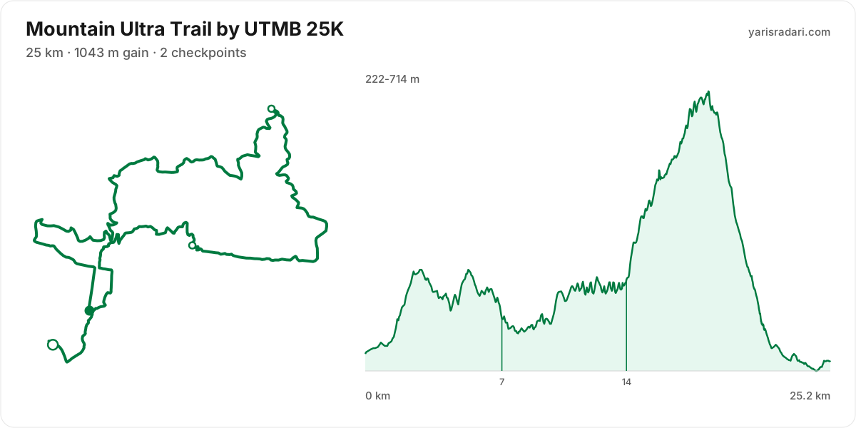
| 25K | 25 km | 1043 m D+ | 35 | GPX |
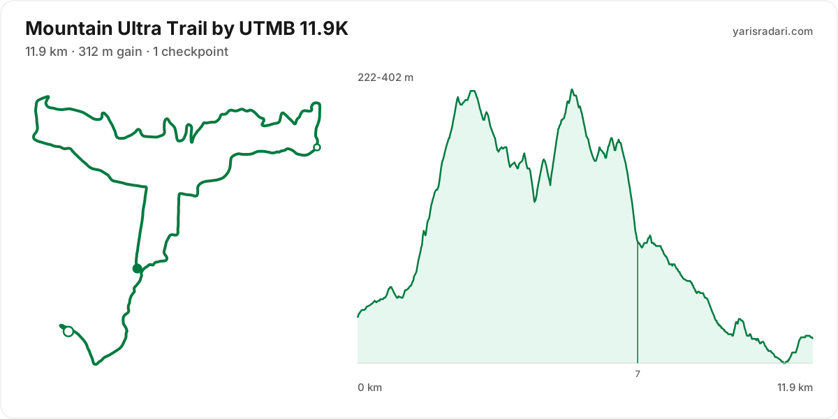
| 11.9K | 11.9 km | 312 m D+ | 15 | GPX |
There are 6 courses: 168K (8014 m D+); 100K (4717 m D+); 58K (3005 m D+); 43K (2312 m D+); 25K (1043 m D+); 11.9K (312 m D+).
Course map and elevation profile
What the weather is usually like here
- Over the last 5 years this week typically ran 10°C to 20°C here, with a high of 29°C and a low of 7°C.
- 23% of those days saw rain. A real forecast lands about two weeks out and will appear here then.
- Typical daily maximum wind was 17 km/h (a light breeze), with 31 km/h the highest value in the sample.
- Sunrise 07:23, sunset 17:30.
The race is more than two weeks out, so these are averages of recent years for the same week, not a forecast. A real forecast appears here closer to the day.
Race briefing
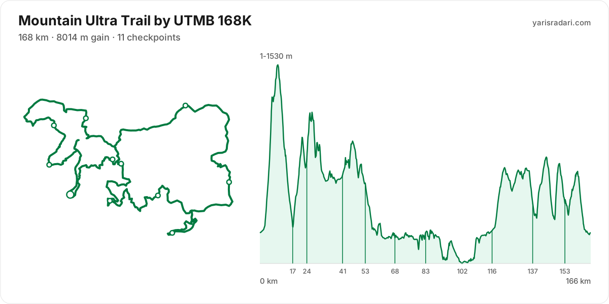
168K course166 km · 8016 m gain · 31% uphill · 11 aid stations
- Steep climb (10%+)
- Climb (3-10%)
- Flat
- Descent
- Steep descent (12%+)
The published GPX measures 166 km with 8016 m of climbing, 48 m per km. The course sits between 0 m and 1533 m of altitude. 57% of the gain sits in the first half.
- 0-17 km · Start → Cradock Pass: 1430 m up / 1382 m down; the stretch keeps rolling.
- 17-24 km · Cradock Pass → Montagu Pass: 793 m up / 266 m down; the stretch climbs.
- 24-41 km · Montagu Pass → Herold Wines: 860 m up / 999 m down; the stretch keeps rolling.
- 41-53 km · Herold Wines → Tierkop: 745 m up / 798 m down; the stretch keeps rolling.
- 53-68 km · Tierkop → Garden Route Dam: 310 m up / 733 m down; the stretch descends.
- 68-83 km · Garden Route Dam → Groeneweide: 446 m up / 405 m down; the stretch keeps rolling.
- 83-102 km · Groeneweide → Wilderness: 500 m up / 738 m down; the stretch descends.
- 102-116 km · Wilderness → Oakhurst: 439 m up / 196 m down; the stretch climbs.
- 116-137 km · Oakhurst → Bergplaas: 914 m up / 683 m down; the stretch climbs.
- 137-153 km · Bergplaas → Tierkop: 1049 m up / 1058 m down; the stretch keeps rolling.
- 153-166 km · Tierkop → Finish: 529 m up / 756 m down; the stretch descends.
The race climbs from the gun: 603 m over the first 5 km. Do not chase the crowd, the two minutes you win here get taken back with interest.
The backbone of the course runs from km 1 to km 9: 1285 m over 8.3 km at 16% average, its steepest roughly 250 m section averaging 45% on the GPX trace. Heaviest kilometres: km 6 407 m, km 5 246 m, km 4 213 m, km 8 141 m. Running is not on the menu at this grade; settle into a hike from the bottom and load the poles, short steps.
The longest drag runs from km 102 to km 123: net 745 m over 21 km at 4% average, its steepest roughly 250 m section averaging 17%, 964 m of climbing in total with 219 m given back. Heaviest kilometres: km 120 129 m, km 119 111 m, km 109 110 m, km 121 98 m. This is hiking terrain, not running terrain. Walk it with intent and keep your heart rate off the ceiling.
The longest descent starts at km 46 and loses 828 m by km 80 at 2% average, its steepest roughly 250 m section averaging 19%. Its length can load the quads, so begin under control and build rhythm only when the ground and visibility allow it. The drop at km 9 averages 33% on the GPX trace over its steepest roughly 250 m section; shorten the stride, stay balanced and set speed to the ground instead of braking continuously.
The last 6 km drop 416 m. If anything is left in your legs, spend it here.
You reach the climb after Cradock Pass with about 1382 m of descent already in your quads; treat its first half as recovery effort.
A steep pitch starts within about 0.3 km of Cradock Pass; keep the stop short and do not enter it on cooled-down legs.
A steep pitch starts within about 1.7 km of Groeneweide; keep the stop short and do not enter it on cooled-down legs.
You reach the climb after Wilderness with about 738 m of descent already in your quads; treat its first half as recovery effort.
The leg from Oakhurst to Bergplaas is long and unsupported: 21 km and 914 m of climbing with no aid in between, so leave Oakhurst with full capacity.
A steep pitch starts within about 1.8 km of Tierkop; keep the stop short and do not enter it on cooled-down legs.
- The organiser lists 168 km; the published GPX measures 166 km. The technical course notes use the published GPX measurement.
- This course reaches 1533 m. At the high-point coordinate, the same week historically ran 6°C to 16°C. Typical daily maximum wind was 16 km/h, reaching 27 km/h in the sample. This is climate history, not the race-day forecast; keep the shell accessible if race week looks similar.
- Sunset is 17:30 and the finish cut-off is 14:00. A runner using the full time allowance spends the final 13 hours 53 minutes in darkness.
- Get the headtorch out before sunset and keep spare batteries or a power bank dry and immediately accessible. A spare buried at the bottom of the pack is not an emergency spare.
- Check reflective course markers regularly in the dark. If the markings disappear, stop moving forward, return to the last marker and confirm the route against the GPX or organiser app.
- At cut-off pace you run into a second night. Plan the sleep question before race day: an hour gained on the first night costs two on the second.
- Consider bringing poles. The course averages 48 m of gain per km and the longest climb averaging over 5% runs 8.3 km; if you have trained with them and the organiser allows them, use them on the climbs and stow them on runnable ground.
Course-profile notes are generated from GPX grade data; terrain, rules, aid stations and weather are added only when separately sourced.
Aid stations
Key decision points
Cradock Passkm 17
- Drinks only; arrive carrying your own food.
- A heavy leg is next: 7.1 km with 720 m of climbing.
- Cut-off: 5h 45m after the start.
Montagu Passkm 24
- Drinks only; arrive carrying your own food.
- A heavy leg is next: 18 km with 915 m of climbing.
- A 30% pitch starts about 0.8 km after the station; do not enter it cooled down.
- Cut-off: 8h after the start.
Herold Wineskm 41
- Collect food and fluids and leave within 60-90 seconds.
- Crew access is allowed here.
- A heavy leg is next: 11 km with 744 m of climbing.
- Cut-off: 12h 45m after the start.
Tierkopkm 53
- Collect food and fluids and leave within 60-90 seconds.
- Your drop bag waits here; work off your prepared list.
- A heavy leg is next: 15 km with 308 m of climbing.
- Cut-off: 16h 30m after the start.
Garden Route Damkm 68
- Collect food and fluids and leave within 60-90 seconds.
- Crew access is allowed here.
- A heavy leg is next: 15 km with 413 m of climbing.
- Cut-off: 20h after the start.
Wildernesskm 102
- Collect food and fluids and leave within 60-90 seconds.
- Crew access is allowed here.
- A heavy leg is next: 15 km with 430 m of climbing.
- Cut-off: 29h after the start.
Oakhurstkm 116
- Collect food and fluids and leave within 60-90 seconds.
- Your drop bag waits here; work off your prepared list.
- Crew access is allowed here.
- A heavy leg is next: 21 km with 927 m of climbing.
- The longest unsupported stretch starts here: 21 km. Leave with full capacity.
- Cut-off: 33h after the start.
Tierkopkm 153
- Collect food and fluids and leave within 60-90 seconds.
- Your drop bag waits here; work off your prepared list.
- A heavy leg is next: 13 km with 515 m of climbing.
- Cut-off: 45h 45m after the start.
- The longest stretch between official aid stations runs from Oakhurst (km 116) to Bergplaas (km 137): 21 km, with 927 m of climbing in between. Top up at Oakhurst and size what you carry to the expected duration and your own drinking rate.
- Drinks only, no food, at Cradock Pass (km 17) and Montagu Pass (km 24). Loosen the flask caps on approach; with no queue, refill and leave in 20-30 seconds. Carry the food you will need from the previous station.
- Food is available at Herold Wines (km 41) and Tierkop (km 53) and 7 more. Decide what you need before reaching the table; without a planned special task, collect food and fluids and leave within 60-90 seconds. Finish eating on the next calm, suitable section.
- Drop bags at Tierkop (km 53), Oakhurst (km 116), and Tierkop (km 153). Write down the equipment and food you expect to replace before the race so the decision is already made when you arrive.
- Crew support is permitted only at Herold Wines (km 41), Garden Route Dam (km 68), Wilderness (km 102), Oakhurst (km 116), and Finish (km 168). This is not the same as a drop bag: plan equipment and food hand-offs around these stations, then verify wristband, bag and transport rules with the organiser.
- The heaviest leg runs from Start (km 0) to Cradock Pass (km 17): 17 km with 1430 m of climbing. Treat it as the slowest part of your day and get your food out before it.
- Medical support is available at Herold Wines (km 41), Tierkop (km 53), Oakhurst (km 116), and Tierkop (km 153). If something is wrong with your feet or your stomach, deal with it there rather than pushing on.
- About 0.8 km after Montagu Pass (km 24), a roughly 250 m section averaging 30% begins. Only drinks are served here, so fill the bottles and carry your own food in, then enter the climb at a controlled effort.
- The overall cut-off is 50h, including all checkpoint stops. Build the plan around the official leg budgets below, not a flat-course average pace.
- Relative to distance and climbing, the tightest official time budget runs from Cradock Pass (km 17) to Montagu Pass (km 24): the official time budget is 2h 15m for 7 km and 793 m of climbing. Station stops come out of that same budget, so do not enter the leg already behind schedule.
Official cut-off ladder
| Leg | Distance | D+ | Official time budget | Closes |
|---|---|---|---|---|
| Start → Cradock Pass | 17 km | 1430 m | 5h 45m | start + 5h 45m |
| Cradock Pass → Montagu Pass | 7.1 km | 793 m | 2h 15m | start + 8h |
| Montagu Pass → Herold Wines | 18 km | 860 m | 4h 45m | start + 12h 45m |
| Herold Wines → Tierkop | 11 km | 745 m | 3h 45m | start + 16h 30m |
| Tierkop → Garden Route Dam | 15 km | 310 m | 3h 30m | start + 20h |
| Garden Route Dam → Groeneweide | 15 km | 446 m | 3h 30m | start + 23h 30m |
| Groeneweide → Wilderness | 18 km | 500 m | 5h 30m | start + 29h |
| Wilderness → Oakhurst | 15 km | 439 m | 4h | start + 33h |
| Oakhurst → Bergplaas | 21 km | 914 m | 6h 30m | start + 39h 30m |
| Bergplaas → Tierkop | 16 km | 1049 m | 6h 15m | start + 45h 45m |
| Tierkop → Finishpasses Trail Kiosk, which has no time limit | 15 km | 529 m | 4h 15m | start + 50h |
Budgets are derived from the cut-off times published by the organiser; they are not a personal finish estimate.
| Station | Km | From previous | Supplies | Medical | Crew | Cut-off |
|---|---|---|---|---|---|---|
| Start | 0 | — | — | No | No | — |
| Cradock Pass | 17 | 17 | Drinks | No | No | Friday 17:45 |
| Montagu Pass | 24 | 7.1 | Drinks | No | No | Friday 20:00 |
| Herold Wines | 41 | 18 | Food | Yes | Yes | Saturday 00:45 |
| TierkopDrop bag | 53 | 11 | Food | Yes | No | Saturday 04:30 |
| Garden Route Dam | 68 | 15 | Food | No | Yes | Saturday 08:00 |
| Groeneweide | 83 | 15 | Food | No | No | Saturday 11:30 |
| Wilderness | 102 | 18 | Food | No | Yes | Saturday 17:00 |
| OakhurstDrop bag | 116 | 15 | Food | Yes | Yes | Saturday 21:00 |
| Bergplaas | 137 | 21 | Food | No | No | Sunday 03:30 |
| TierkopDrop bag | 153 | 16 | Food | Yes | No | Sunday 09:45 |
| Trail Kiosk | 166 | 13 | Food | No | No | — |
| Finish | 168 | 2 | None | No | Yes | Sunday 14:00 |
Aid station details come from the list published by the organiser; confirm them at the official source before race day.
Plan your cutoffs for this course
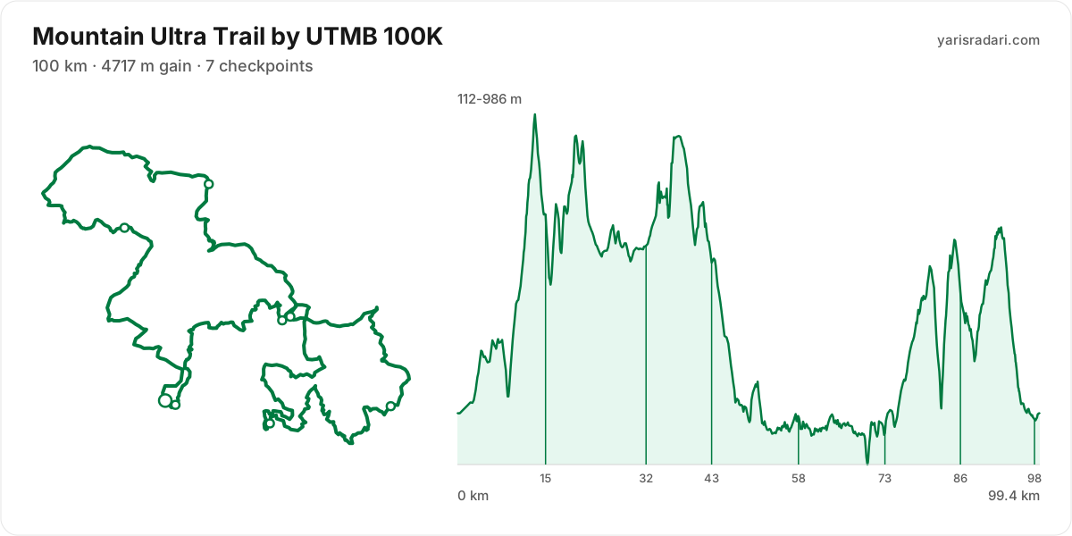
100K course99 km · 4717 m gain · 32% uphill · 7 aid stations
- Steep climb (10%+)
- Climb (3-10%)
- Flat
- Descent
- Steep descent (12%+)
The published GPX measures 99 km with 4717 m of climbing, 47 m per km. The course sits between 110 m and 986 m of altitude. 55% of the gain sits in the first half.
- 0-15 km · Start → Montagu Pass: 999 m up / 513 m down; the stretch climbs.
- 15-32 km · Montagu Pass → Herold Wines: 827 m up / 894 m down; the stretch keeps rolling.
- 32-43 km · Herold Wines → Tierkop: 712 m up / 746 m down; the stretch keeps rolling.
- 43-58 km · Tierkop → Garden Route Dam: 311 m up / 705 m down; the stretch descends.
- 58-73 km · Garden Route Dam → Groeneweide: 384 m up / 414 m down; the stretch keeps rolling.
- 73-86 km · Groeneweide → Tierkop: 969 m up / 614 m down; the stretch climbs.
- 86-99 km · Tierkop → Finish: 514 m up / 831 m down; the stretch descends.
The race climbs from the gun: 135 m over the first 5 km. Do not chase the crowd, the two minutes you win here get taken back with interest.
The backbone of the course runs from km 1 to km 13: net 732 m over 13 km at 6% average, its steepest roughly 250 m section averaging 25%, 975 m of climbing in total with 243 m given back. Heaviest kilometres: km 12 185 m, km 13 172 m, km 10 170 m, km 4 97 m. This is hiking terrain, not running terrain. Walk it with intent and keep your heart rate off the ceiling.
The steepest wall stands between km 83 and km 85: net 421 m over 2.3 km at 18% average, its steepest roughly 250 m section averaging 34% on the GPX trace, 477 m of climbing in total with 56 m given back. Kilometre by kilometre: km 84 242 m, km 85 95 m. By the time you start it, about 79% of the day's climbing is behind you. Running is not on the menu at this grade; settle into a hike from the bottom and load the poles, short steps.
The longest descent starts at km 38 and loses 818 m by km 70 at 3% average, its steepest roughly 250 m section averaging 19%. Its length can load the quads, so begin under control and build rhythm only when the ground and visibility allow it. The drop at km 81 averages 31% on the GPX trace over its steepest roughly 250 m section; shorten the stride, stay balanced and set speed to the ground instead of braking continuously.
The last 6 km drop 424 m. If anything is left in your legs, spend it here.
A steep pitch starts within about 0.9 km of Montagu Pass; keep the stop short and do not enter it on cooled-down legs.
The leg from Montagu Pass to Herold Wines is long and unsupported: 17 km and 827 m of climbing with no aid in between, so leave Montagu Pass with full capacity.
You reach the climb after Groeneweide with about 414 m of descent already in your quads; treat its first half as recovery effort.
- This course reaches 986 m. At the high-point coordinate, the same week historically ran 6°C to 17°C. Typical daily maximum wind was 16 km/h, reaching 27 km/h in the sample. This is climate history, not the race-day forecast; keep the shell accessible if race week looks similar.
- Start 05:00, sunrise 07:23: the first 2 hours 23 minutes are run in the dark. The headtorch goes on your head at the start, not in your pack.
- Sunset is 17:30 and the finish cut-off is 06:00. A runner using the full time allowance spends the final 12 hours 30 minutes in darkness.
- Get the headtorch out before sunset and keep spare batteries or a power bank dry and immediately accessible. A spare buried at the bottom of the pack is not an emergency spare.
- Check reflective course markers regularly in the dark. If the markings disappear, stop moving forward, return to the last marker and confirm the route against the GPX or organiser app.
- Poles are strongly recommended for this profile. The course averages 47 m of gain per km and the longest climb averaging over 5% runs 13 km; if you have trained with them and the organiser allows them, use them on the climbs and stow them on runnable ground.
- 13% of the course is steep descent. Increase your cadence instead of braking, or your quads go early.
Course-profile notes are generated from GPX grade data; terrain, rules, aid stations and weather are added only when separately sourced.
Aid stations
Key decision points
Montagu Passkm 15
- Collect food and fluids and leave within 60-90 seconds.
- A heavy leg is next: 17 km with 825 m of climbing.
- The longest unsupported stretch starts here: 17 km. Leave with full capacity.
- A 26% pitch starts about 1 km after the station; do not enter it cooled down.
- Cut-off: 3h 30m after the start.
Herold Wineskm 32
- Collect food and fluids and leave within 60-90 seconds.
- Crew access is allowed here.
- A heavy leg is next: 11 km with 714 m of climbing.
- Cut-off: 7h 45m after the start.
Tierkopkm 43
- Collect food and fluids and leave within 60-90 seconds.
- Your drop bag waits here; work off your prepared list.
- A heavy leg is next: 15 km with 288 m of climbing.
- Cut-off: 10h 30m after the start.
Garden Route Damkm 58
- No supplies, timing only.
- Crew access is allowed here.
- A heavy leg is next: 15 km with 394 m of climbing.
- Cut-off: 13h 30m after the start.
Groeneweidekm 73
- Collect food and fluids and leave within 60-90 seconds.
- A heavy leg is next: 13 km with 981 m of climbing.
- Cut-off: 17h after the start.
Tierkopkm 86
- Collect food and fluids and leave within 60-90 seconds.
- A heavy leg is next: 13 km with 496 m of climbing.
- Cut-off: 21h after the start.
- The longest stretch between official aid stations runs from Montagu Pass (km 15) to Herold Wines (km 32): 17 km, with 825 m of climbing in between. Top up at Montagu Pass and size what you carry to the expected duration and your own drinking rate.
- Garden Route Dam (km 58) is a timing point only, with nothing on the table. Load up as you leave Tierkop.
- Food is available at Montagu Pass (km 15) and Herold Wines (km 32) and 4 more. Decide what you need before reaching the table; without a planned special task, collect food and fluids and leave within 60-90 seconds. Finish eating on the next calm, suitable section.
- Drop bag at Tierkop (km 43). Write down the equipment and food you expect to replace before the race so the decision is already made when you arrive.
- Crew support is permitted only at Start (km 0), Herold Wines (km 32), and Garden Route Dam (km 58). This is not the same as a drop bag: plan equipment and food hand-offs around these stations, then verify wristband, bag and transport rules with the organiser.
- The heaviest leg runs from Start (km 0) to Montagu Pass (km 15): 15 km with 995 m of climbing. Treat it as the slowest part of your day and get your food out before it.
- Medical support is available at Herold Wines (km 32), Tierkop (km 43), and Tierkop (km 86). If something is wrong with your feet or your stomach, deal with it there rather than pushing on.
- About 1 km after Montagu Pass (km 15), a roughly 250 m section averaging 26% begins. Choose food you know you digest easily and fill the bottles, then enter the climb at a controlled effort.
- The overall cut-off is 25h, including all checkpoint stops. Build the plan around the official leg budgets below, not a flat-course average pace.
- Relative to distance and climbing, the tightest official time budget runs from Start to Montagu Pass (km 15): the official time budget is 3h 30m for 15 km and 999 m of climbing. Station stops come out of that same budget, so do not enter the leg already behind schedule.
Official cut-off ladder
| Leg | Distance | D+ | Official time budget | Closes |
|---|---|---|---|---|
| Start → Montagu Pass | 15 km | 999 m | 3h 30m | start + 3h 30m |
| Montagu Pass → Herold Wines | 17 km | 827 m | 4h 15m | start + 7h 45m |
| Herold Wines → Tierkop | 11 km | 712 m | 2h 45m | start + 10h 30m |
| Tierkop → Garden Route Dam | 15 km | 311 m | 3h | start + 13h 30m |
| Garden Route Dam → Groeneweide | 15 km | 384 m | 3h 30m | start + 17h |
| Groeneweide → Tierkop | 13 km | 969 m | 4h | start + 21h |
| Tierkop → Finishpasses Trail Kiosk, which has no time limit | 15 km | 514 m | 4h | start + 25h |
Budgets are derived from the cut-off times published by the organiser; they are not a personal finish estimate.
| Station | Km | From previous | Supplies | Medical | Crew | Cut-off |
|---|---|---|---|---|---|---|
| Start | 0 | — | — | No | Yes | — |
| Montagu Pass | 15 | 15 | Food | No | No | Saturday 08:30 |
| Herold Wines | 32 | 17 | Food | Yes | Yes | Saturday 12:45 |
| TierkopDrop bag | 43 | 11 | Food | Yes | No | Saturday 15:30 |
| Garden Route Dam | 58 | 15 | None | No | Yes | Saturday 18:30 |
| Groeneweide | 73 | 15 | Food | No | No | Saturday 22:00 |
| Tierkop | 86 | 13 | Food | Yes | No | Sunday 02:00 |
| Trail Kiosk | 98 | 13 | Food | No | No | — |
| Finish | 101 | 2 | None | No | No | Sunday 06:00 |
Aid station details come from the list published by the organiser; confirm them at the official source before race day.
Plan your cutoffs for this course
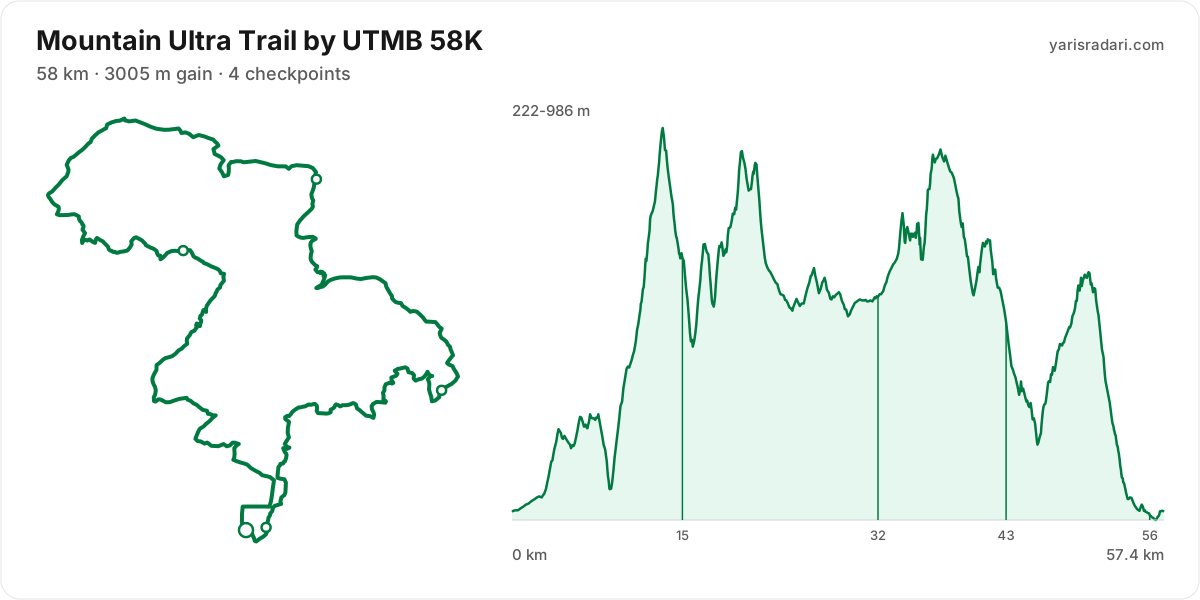
58K course57 km · 3005 m gain · 39% uphill · 4 aid stations
- Steep climb (10%+)
- Climb (3-10%)
- Flat
- Descent
- Steep descent (12%+)
The published GPX measures 57 km with 3005 m of climbing, 52 m per km. The course sits between 222 m and 986 m of altitude. 59% of the gain sits in the first half.
- 0-15 km · Start → Montagu Pass: 1001 m up / 509 m down; the stretch climbs.
- 15-32 km · Montagu Pass → Herold Wines: 817 m up / 885 m down; the stretch keeps rolling.
- 32-43 km · Herold Wines → Tierkop: 700 m up / 750 m down; the stretch keeps rolling.
- 43-57 km · Tierkop → Finish: 487 m up / 861 m down; the stretch descends.
The race climbs from the gun: 145 m over the first 4.6 km. Do not chase the crowd, the two minutes you win here get taken back with interest.
The backbone of the course runs from km 9 to km 13: 685 m over 4.6 km at 15% average, its steepest roughly 250 m section averaging 25%. Kilometre by kilometre: km 10 170 m, km 11 80 m, km 12 185 m, km 13 175 m. Running is off the table only in the steepest roughly 250 m core; hike that part with short steps and run again once the grade eases.
The steepest wall stands between km 16 and km 21: net 347 m over 5.4 km at 6% average, its steepest roughly 250 m section averaging 27%, 612 m of climbing in total with 265 m given back. Kilometre by kilometre: km 17 193 m, km 18 60 m, km 19 122 m, km 20 131 m, km 21 51 m. This is hiking terrain, not running terrain. Walk it with intent and keep your heart rate off the ceiling.
The late climb from km 46 to km 50: net 319 m over 4.1 km at 8% average, its steepest roughly 250 m section averaging 17%, 368 m of climbing in total with 49 m given back. Kilometre by kilometre: km 47 97 m, km 48 93 m, km 49 58 m, km 50 94 m. By the time you start it, about 86% of the day's climbing is behind you. At this point in the day most runners walk this gradient. Settle into a hiking rhythm and let the metres come.
The longest descent starts at km 51 and loses 481 m by km 57 at 8% average, its steepest roughly 250 m section averaging 22%. Its length can load the quads, so begin under control and build rhythm only when the ground and visibility allow it. The drop at km 20 averages 29% over its steepest roughly 250 m section; shorten the stride, stay balanced and set speed to the ground instead of braking continuously.
The last 6 km drop 415 m. If anything is left in your legs, spend it here.
A steep pitch starts within about 0.9 km of Montagu Pass; keep the stop short and do not enter it on cooled-down legs.
The leg from Montagu Pass to Herold Wines is long and unsupported: 17 km and 817 m of climbing with no aid in between, so leave Montagu Pass with full capacity.
- The organiser lists 58 km; the published GPX measures 57.4 km. The technical course notes use the published GPX measurement.
- This course reaches 986 m. At the high-point coordinate, the same week historically ran 6°C to 17°C. Typical daily maximum wind was 16 km/h, reaching 27 km/h in the sample. This is climate history, not the race-day forecast; keep the shell accessible if race week looks similar.
- Start 06:30, sunrise 07:23: the first 53 minutes are run in the dark. The headtorch goes on your head at the start, not in your pack.
- Sunset is 17:30 and the finish cut-off is 21:30. A runner using the full time allowance spends the final 4 hours in darkness.
- Get the headtorch out before sunset and keep spare batteries or a power bank dry and immediately accessible. A spare buried at the bottom of the pack is not an emergency spare.
- Check reflective course markers regularly in the dark. If the markings disappear, stop moving forward, return to the last marker and confirm the route against the GPX or organiser app.
- Poles are strongly recommended for this profile. The course averages 52 m of gain per km and the longest climb averaging over 5% runs 5.4 km; if you have trained with them and the organiser allows them, use them on the climbs and stow them on runnable ground.
- 17% of the course is steep descent. Increase your cadence instead of braking, or your quads go early.
Course-profile notes are generated from GPX grade data; terrain, rules, aid stations and weather are added only when separately sourced.
Aid stations
Key decision points
Montagu Passkm 15
- Collect food and fluids and leave within 60-90 seconds.
- A heavy leg is next: 17 km with 814 m of climbing.
- The longest unsupported stretch starts here: 17 km. Leave with full capacity.
- A 26% pitch starts about 1 km after the station; do not enter it cooled down.
- Cut-off: 4h 30m after the start.
Herold Wineskm 32
- Collect food and fluids and leave within 60-90 seconds.
- A heavy leg is next: 11 km with 703 m of climbing.
- Cut-off: 8h 30m after the start.
Tierkopkm 43
- Collect food and fluids and leave within 60-90 seconds.
- A heavy leg is next: 13 km with 469 m of climbing.
- Cut-off: 12h 30m after the start.
- The longest stretch between official aid stations runs from Montagu Pass (km 15) to Herold Wines (km 32): 17 km, with 814 m of climbing in between. Top up at Montagu Pass and size what you carry to the expected duration and your own drinking rate.
- Food is available at Montagu Pass (km 15) and Herold Wines (km 32) and 2 more. Decide what you need before reaching the table; without a planned special task, collect food and fluids and leave within 60-90 seconds. Finish eating on the next calm, suitable section.
- The heaviest leg runs from Start (km 0) to Montagu Pass (km 15): 15 km with 998 m of climbing. Treat it as the slowest part of your day and get your food out before it.
- Medical support is available at Herold Wines (km 32) and Tierkop (km 43). If something is wrong with your feet or your stomach, deal with it there rather than pushing on.
- About 1 km after Montagu Pass (km 15), a roughly 250 m section averaging 26% begins. Choose food you know you digest easily and fill the bottles, then enter the climb at a controlled effort.
- The overall cut-off is 15h, including all checkpoint stops. Build the plan around the official leg budgets below, not a flat-course average pace.
- Relative to distance and climbing, the tightest official time budget runs from Tierkop (km 43) to Finish (km 58): the official time budget is 2h 30m for 15 km and 487 m of climbing. Station stops come out of that same budget, so do not enter the leg already behind schedule.
Official cut-off ladder
| Leg | Distance | D+ | Official time budget | Closes |
|---|---|---|---|---|
| Start → Montagu Pass | 15 km | 1001 m | 4h 30m | start + 4h 30m |
| Montagu Pass → Herold Wines | 17 km | 817 m | 4h | start + 8h 30m |
| Herold Wines → Tierkop | 11 km | 700 m | 4h | start + 12h 30m |
| Tierkop → Finishpasses Trail Kiosk, which has no time limit | 15 km | 487 m | 2h 30m | start + 15h |
Budgets are derived from the cut-off times published by the organiser; they are not a personal finish estimate.
| Station | Km | From previous | Supplies | Medical | Crew | Cut-off |
|---|---|---|---|---|---|---|
| Start | 0 | — | — | No | No | — |
| Montagu Pass | 15 | 15 | Food | No | No | Saturday 11:00 |
| Herold Wines | 32 | 17 | Food | Yes | No | Saturday 15:00 |
| Tierkop | 43 | 11 | Food | Yes | No | Saturday 19:00 |
| Trail Kiosk | 56 | 13 | Food | No | No | — |
| Finish | 58 | 2 | None | No | No | Saturday 21:30 |
Aid station details come from the list published by the organiser; confirm them at the official source before race day.
Plan your cutoffs for this course
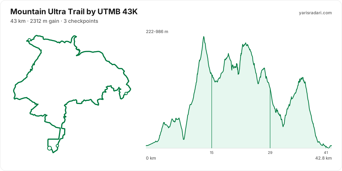
43K course43 km · 2312 m gain · 37% uphill · 3 aid stations
- Steep climb (10%+)
- Climb (3-10%)
- Flat
- Descent
- Steep descent (12%+)
The published GPX measures 43 km with 2312 m of climbing, 54 m per km. The course sits between 222 m and 986 m of altitude. 59% of the gain sits in the first half.
- 0-15 km · Start → Montagu Pass: 993 m up / 504 m down; the stretch climbs.
- 15-29 km · Montagu Pass → Tierkop: 809 m up / 902 m down; the stretch keeps rolling.
- 29-43 km · Tierkop → Finish: 510 m up / 904 m down; the stretch descends.
The race climbs from the gun: 90 m over the first 3.4 km. Do not chase the crowd, the two minutes you win here get taken back with interest.
The backbone of the course runs from km 9 to km 13: 700 m over 4.6 km at 15% average, its steepest roughly 250 m section averaging 24%. Kilometre by kilometre: km 10 172 m, km 11 86 m, km 12 179 m, km 13 170 m. Running is not on the menu at this grade; settle into a hike from the bottom and load the poles, short steps.
The steepest wall stands between km 21 and km 23: net 206 m over 1.8 km at 12% average, its steepest roughly 250 m section averaging 29%, 265 m of climbing in total with 59 m given back. Kilometre by kilometre: km 22 182 m, km 23 98 m. Running is off the table only in the steepest roughly 250 m core; hike that part with short steps and run again once the grade eases.
The late climb from km 32 to km 36: net 319 m over 4.1 km at 8% average, its steepest roughly 250 m section averaging 14%, 373 m of climbing in total with 54 m given back. Kilometre by kilometre: km 33 101 m, km 34 78 m, km 35 75 m, km 36 90 m. By the time you start it, about 81% of the day's climbing is behind you. At this point in the day most runners walk this gradient. Settle into a hiking rhythm and let the metres come.
The longest descent starts at km 36 and loses 479 m by km 42 at 8% average, its steepest roughly 250 m section averaging 21%. Its length can load the quads, so begin under control and build rhythm only when the ground and visibility allow it. The drop at km 27 averages 23% over its steepest roughly 250 m section; shorten the stride, stay balanced and set speed to the ground instead of braking continuously.
The last 5.1 km drop 256 m. If anything is left in your legs, spend it here.
A steep pitch starts within about 0.8 km of Montagu Pass; keep the stop short and do not enter it on cooled-down legs.
The leg from Montagu Pass to Tierkop is long and unsupported: 13 km and 809 m of climbing with no aid in between, so leave Montagu Pass with full capacity.
- This course reaches 986 m. At the high-point coordinate, the same week historically ran 6°C to 17°C. Typical daily maximum wind was 16 km/h, reaching 27 km/h in the sample. This is climate history, not the race-day forecast; keep the shell accessible if race week looks similar.
- Sunset is 17:30 and the finish cut-off is 20:00. A runner using the full time allowance spends the final 2 hours 30 minutes in darkness.
- Get the headtorch out before sunset and keep spare batteries or a power bank dry and immediately accessible. A spare buried at the bottom of the pack is not an emergency spare.
- Check reflective course markers regularly in the dark. If the markings disappear, stop moving forward, return to the last marker and confirm the route against the GPX or organiser app.
- Poles are strongly recommended for this profile. The course averages 54 m of gain per km and the longest climb averaging over 5% runs 4.6 km; if you have trained with them and the organiser allows them, use them on the climbs and stow them on runnable ground.
- 12% of the course is steep descent. Increase your cadence instead of braking, or your quads go early.
Course-profile notes are generated from GPX grade data; terrain, rules, aid stations and weather are added only when separately sourced.
Aid stations
Key decision points
Montagu Passkm 15
- Collect food and fluids and leave within 60-90 seconds.
- A heavy leg is next: 13 km with 809 m of climbing.
- A 10% pitch starts about 2 km after the station; do not enter it cooled down.
- Cut-off: 4h after the start.
Tierkopkm 29
- Collect food and fluids and leave within 60-90 seconds.
- A heavy leg is next: 13 km with 489 m of climbing.
- Cut-off: 9h after the start.
- The longest stretch between official aid stations runs from Start (km 0) to Montagu Pass (km 15): 15 km, with 993 m of climbing in between. Top up at Start and size what you carry to the expected duration and your own drinking rate.
- Drinks only, no food, at Trail Kiosk (km 41). Loosen the flask caps on approach; with no queue, refill and leave in 20-30 seconds. Carry the food you will need from the previous station.
- Food is available at Montagu Pass (km 15) and Tierkop (km 29). Decide what you need before reaching the table; without a planned special task, collect food and fluids and leave within 60-90 seconds. Finish eating on the next calm, suitable section.
- Crew support is permitted only at Finish (km 43). This is not the same as a drop bag: plan equipment and food hand-offs around these stations, then verify wristband, bag and transport rules with the organiser.
- Another heavy leg runs from Montagu Pass (km 15) to Tierkop (km 29): 13 km with 809 m of climbing. Treat it as the slowest part of your day and get your food out before it.
- Medical support is available at Montagu Pass (km 15) and Tierkop (km 29). If something is wrong with your feet or your stomach, deal with it there rather than pushing on.
- About 2 km after Montagu Pass (km 15), a roughly 250 m section averaging 10% begins. Choose food you know you digest easily and fill the bottles, then enter the climb at a controlled effort.
- The overall cut-off is 12h, including all checkpoint stops. Build the plan around the official leg budgets below, not a flat-course average pace.
- Relative to distance and climbing, the tightest official time budget runs from Tierkop (km 29) to Finish (km 43): the official time budget is 3h for 15 km and 510 m of climbing. Station stops come out of that same budget, so do not enter the leg already behind schedule.
| Station | Km | From previous | Supplies | Medical | Crew | Cut-off |
|---|---|---|---|---|---|---|
| Start | 0 | — | — | No | No | — |
| Montagu Pass | 15 | 15 | Food | Yes | No | Saturday 12:00 |
| Tierkop | 29 | 13 | Food | Yes | No | Saturday 17:00 |
| Trail Kiosk | 41 | 13 | Drinks | No | No | — |
| Finish | 43 | 2 | None | No | Yes | Saturday 20:00 |
Aid station details come from the list published by the organiser; confirm them at the official source before race day.
Plan your cutoffs for this course
25K course25 km · 1043 m gain · 22% uphill · 2 aid stations
- Steep climb (10%+)
- Climb (3-10%)
- Flat
- Descent
- Steep descent (12%+)
The published GPX measures 25 km with 1043 m of climbing, 41 m per km. The course sits between 222 m and 716 m of altitude. 49% of the gain sits in the first half.
- 0-7.4 km · Start → Waterworks: 285 m up / 216 m down; the stretch keeps rolling.
- 7.4-14 km · Waterworks → George Dam: 312 m up / 250 m down; the stretch keeps rolling.
- 14-25 km · George Dam → Finish: 446 m up / 589 m down; the stretch descends.
The race climbs from the gun: 79 m over the first 2 km. Do not chase the crowd, the two minutes you win here get taken back with interest.
The backbone of the course runs from km 8 to km 18: net 413 m over 10 km at 4% average, its steepest roughly 250 m section averaging 17%, 686 m of climbing in total with 273 m given back. Heaviest kilometres: km 15 125 m, km 18 110 m, km 16 90 m, km 11 65 m. This is hiking terrain, not running terrain. Walk it with intent and keep your heart rate off the ceiling.
The longest descent starts at km 18 and loses 480 m by km 24 at 9% average, its steepest roughly 250 m section averaging 20%. Its length can load the quads, so begin under control and build rhythm only when the ground and visibility allow it. The drop at km 6 averages 12% over its steepest roughly 250 m section; shorten the stride, stay balanced and set speed to the ground instead of braking continuously.
The last 3 km are close to flat. Plan your finishing pace around that, there is nothing left to save.
A steep pitch starts within about 0.8 km of Waterworks; keep the stop short and do not enter it on cooled-down legs.
- This course reaches 716 m. At the high-point coordinate, the same week historically ran 7°C to 17°C. Typical daily maximum wind was 14 km/h, reaching 26 km/h in the sample. This is climate history, not the race-day forecast; keep the shell accessible if race week looks similar.
- Even at cut-off pace you finish 3 hours 30 minutes before sunset. This one is run entirely in daylight.
- Consider bringing poles. The course averages 41 m of gain per km; if you have trained with them and the organiser allows them, use them on the climbs and stow them on runnable ground.
- Point to point: the finish sits 0.9 km from the start as the crow flies. Sort the shuttle and your drop bag before race day.
Course-profile notes are generated from GPX grade data; terrain, rules, aid stations and weather are added only when separately sourced.
Aid stations
Key decision points
Waterworkskm 7.4
- Collect food and fluids and leave within 60-90 seconds.
- A heavy leg is next: 6.7 km with 303 m of climbing.
- Cut-off: 2h after the start.
George Damkm 14
- Collect food and fluids and leave within 60-90 seconds.
- The heaviest leg is next: 11 km with 454 m of climbing.
- The longest unsupported stretch starts here: 11 km. Leave with full capacity.
- A 17% pitch starts about 0.3 km after the station; do not enter it cooled down.
- Cut-off: 3h 30m after the start.
- The longest stretch between official aid stations runs from George Dam (km 14) to Finish (km 25): 11 km, with 454 m of climbing in between. Top up at George Dam and size what you carry to the expected duration and your own drinking rate.
- Food is available at Waterworks (km 7) and George Dam (km 14). Decide what you need before reaching the table; without a planned special task, collect food and fluids and leave within 60-90 seconds. Finish eating on the next calm, suitable section.
- Crew support is permitted only at Finish (km 25). This is not the same as a drop bag: plan equipment and food hand-offs around these stations, then verify wristband, bag and transport rules with the organiser.
- Another heavy leg runs from Waterworks (km 7) to George Dam (km 14): 7 km with 303 m of climbing. Treat it as the slowest part of your day and get your food out before it.
- About 0.3 km after George Dam (km 14), a roughly 250 m section averaging 17% begins. Choose food you know you digest easily and fill the bottles, then enter the climb at a controlled effort.
- The overall cut-off is 6h, including all checkpoint stops. Build the plan around the official leg budgets below, not a flat-course average pace.
- Relative to distance and climbing, the tightest official time budget runs from Waterworks (km 7) to George Dam (km 14): the official time budget is 1h 30m for 7 km and 312 m of climbing. Station stops come out of that same budget, so do not enter the leg already behind schedule.
| Station | Km | From previous | Supplies | Medical | Crew | Cut-off |
|---|---|---|---|---|---|---|
| Start | 0 | — | — | No | No | — |
| Waterworks | 7.4 | 7.4 | Food | No | No | Sunday 10:00 |
| George Dam | 14 | 6.7 | Food | No | No | Sunday 11:30 |
| Finish | 25 | 11 | None | No | Yes | Sunday 14:00 |
Aid station details come from the list published by the organiser; confirm them at the official source before race day.
Plan your cutoffs for this course
11.9K course12 km · 312 m gain · 13% uphill · 1 aid station
- Steep climb (10%+)
- Climb (3-10%)
- Flat
- Descent
The published GPX measures 12 km with 312 m of climbing, 26 m per km. The course sits between 222 m and 402 m of altitude. 81% of the gain sits in the first half.
The first 1.5 km are close to flat, good for settling in. Do not set your pace here, the real course starts after.
The backbone of the course runs from km 0 to km 3: 144 m over 2.6 km at 5% average, its steepest roughly 250 m section averaging 11%. Kilometre by kilometre: km 1 17 m, km 2 66 m, km 3 72 m. This is hiking terrain, not running terrain. Walk it with intent and keep your heart rate off the ceiling.
The longest descent starts at km 3 and loses 166 m by km 11 at 2% average, its steepest roughly 250 m section averaging 17%. Its length can load the quads, so begin under control and build rhythm only when the ground and visibility allow it.
The last 2 km are close to flat. Plan your finishing pace around that, there is nothing left to save.
- Even at cut-off pace you finish 3 hours 30 minutes before sunset. This one is run entirely in daylight.
- Poles are optional: 26 m of gain per km. Bring them to protect your legs, not to gain speed.
- The climbing is stacked into the first half. Start easy; even with less climbing later, the descents and accumulated fatigue still have to be managed.
- Point to point: the finish sits 0.9 km from the start as the crow flies. Sort the shuttle and your drop bag before race day.
Course-profile notes are generated from GPX grade data; terrain, rules, aid stations and weather are added only when separately sourced.
Aid stations
- Food is available at Waterworks (km 7). Decide what you need before reaching the table; without a planned special task, collect food and fluids and leave within 60-90 seconds. Finish eating on the next calm, suitable section.
- The heaviest leg runs from Start (km 0) to Waterworks (km 7): 7 km with 280 m of climbing. Treat it as the slowest part of your day and get your food out before it.
- The overall cut-off is 5h, including all checkpoint stops. Build the plan around the official leg budgets below, not a flat-course average pace.
- Relative to distance and climbing, the tightest official time budget runs from Start to Waterworks (km 7): the official time budget is 3h for 7 km and 280 m of climbing. Station stops come out of that same budget, so do not enter the leg already behind schedule.
| Station | Km | From previous | Supplies | Medical | Crew | Cut-off |
|---|---|---|---|---|---|---|
| Start | 0 | — | — | No | No | — |
| Waterworks | 7.3 | 7.3 | Food | No | No | Sunday 12:00 |
| Finish | 12 | 4.6 | None | No | No | Sunday 14:00 |
Aid station details come from the list published by the organiser; confirm them at the official source before race day.
Plan your cutoffs for this course
Calculators for this race
Registration
- StandardThu, Jul 23, 2026 - Sat, May 15, 2027Registration open
Data sources: UTMB World Series, official site (mut.utmb.world) · Last checked:
Tune-up races
Prep races you can run in the weeks before this one, ahead of your taper.
Similar races
Frequently asked questions
(38)
What is Mountain Ultra Trail by UTMB?
The Mountain Ultra Trail or MUT by UTMB is a festival of trail running in the garden city of George, on South Africa’s east coast.
When is Mountain Ultra Trail by UTMB 2027?
Mountain Ultra Trail by UTMB takes place on Thu, May 27, 2027 - Sun, May 30, 2027. Start time: 12:00.
Where does Mountain Ultra Trail by UTMB take place?
Mountain Ultra Trail by UTMB takes place in George, South Africa.
What are the courses and distances of Mountain Ultra Trail by UTMB 2027?
Mountain Ultra Trail by UTMB offers 6 courses: 168K (168 km, 8014 m D+); 100K (100 km, 4717 m D+); 58K (58 km, 3005 m D+); 43K (43 km, 2312 m D+); 25K (25 km, 1043 m D+); 11.9K (11.9 km, 312 m D+).
How hard is Mountain Ultra Trail by UTMB 2027?
Difficulty is measured in km-effort: distance plus ascent divided by 100. The 168K course covers 168 km with 8014 m of climbing, which is 248 km-effort and falls in ITRA category XXL. All courses: 168K 248 km-effort (XXL), 100K 147 km-effort (L), 58K 88 km-effort (M), 43K 66 km-effort (S), 25K 35 km-effort (XS), 11.9K 15 km-effort (XXS).
Is registration for Mountain Ultra Trail by UTMB 2027 open?
Registration appears to be open; the deadline is Sat, May 15, 2027.
When is the registration deadline for Mountain Ultra Trail by UTMB 2027?
The registration deadline for Mountain Ultra Trail by UTMB is Sat, May 15, 2027.
Where are the Mountain Ultra Trail by UTMB photos?
Mountain Ultra Trail by UTMB photos are in the organiser's gallery: https://mut.utmb.world/get-excited/sportograf. The gallery may also cover earlier editions.
What is the official website of Mountain Ultra Trail by UTMB?
Official website: https://mut.utmb.world/
Is the Mountain Ultra Trail by UTMB 2027 course a loop or an out and back?
The 168K course is a single loop with a shared start and finish; measured from the GPX file it runs 166.1 km. The 100K course is a single loop with a shared start and finish; measured from the GPX file it runs 99.4 km. The 58K course is a single loop with a shared start and finish; measured from the GPX file it runs 57.4 km.
Where is the hardest climb at Mountain Ultra Trail by UTMB 2027?
The biggest climb on the 168K course runs from km 1 to km 9: 8.3 km for 1285 m at 16% average; its steepest roughly 250 m section averages 45%. It tops out at 1529 m.
How high does Mountain Ultra Trail by UTMB 2027 go?
The 168K course runs between 0 m and 1533 m with 8016 m of total climbing.
Do you need poles at Mountain Ultra Trail by UTMB 2027?
The 168K course averages 48 m of gain per km with a longest climb of 8.3 km, so poles help noticeably.
Do you need a headtorch at Mountain Ultra Trail by UTMB 2027?
168K: Sunset is 17:30 and the finish cut-off is 14:00. A runner using the full time allowance spends the final 13 hours 53 minutes in darkness. Get the headtorch out before sunset and keep spare batteries or a power bank dry and immediately accessible. A spare buried at the bottom of the pack is not an emergency spare. Check reflective course markers regularly in the dark. If the markings disappear, stop moving forward, return to the last marker and confirm the route against the GPX or organiser app. At cut-off pace you run into a second night. Plan the sleep question before race day: an hour gained on the first night costs two on the second.
What is the weather like at Mountain Ultra Trail by UTMB 2027?
Over the last 5 years the same week here measured 10°C to 20°C, with a high of 29°C, a low of 7°C and rain on 23% of days. A real forecast lands about two weeks out.
Where are the aid stations at Mountain Ultra Trail by UTMB 2027?
The 168K course has 11 stations; the first at km 17 and the last at km 166. The longest gap between them is 21 km, between Oakhurst and Bergplaas.
What is served at the Mountain Ultra Trail by UTMB 2027 aid stations?
For the 168K course: Drinks only: Cradock Pass (17. km), Montagu Pass (24. km).
Is there a drop bag at Mountain Ultra Trail by UTMB 2027?
Yes. On the 168K course the drop bag point is Tierkop (km 53).
What are the cut-off times for the 168K at Mountain Ultra Trail by UTMB 2027?
On the 168K course at Mountain Ultra Trail by UTMB 2027 the finish cut-off is Sunday 14:00. Intermediate cut-offs: Cradock Pass (km 17) Friday 17:45, Montagu Pass (km 24) Friday 20:00, Herold Wines (km 41) Saturday 00:45, Tierkop (km 53) Saturday 04:30, Garden Route Dam (km 68) Saturday 08:00, Groeneweide (km 83) Saturday 11:30, Wilderness (km 102) Saturday 17:00, Oakhurst (km 116) Saturday 21:00, Bergplaas (km 137) Sunday 03:30, Tierkop (km 153) Sunday 09:45.
What are the cut-off times for the 100K at Mountain Ultra Trail by UTMB 2027?
On the 100K course at Mountain Ultra Trail by UTMB 2027 the finish cut-off is Sunday 06:00. Intermediate cut-offs: Montagu Pass (km 15) Saturday 08:30, Herold Wines (km 32) Saturday 12:45, Tierkop (km 43) Saturday 15:30, Garden Route Dam (km 58) Saturday 18:30, Groeneweide (km 73) Saturday 22:00, Tierkop (km 86) Sunday 02:00.
What are the cut-off times for the 58K at Mountain Ultra Trail by UTMB 2027?
On the 58K course at Mountain Ultra Trail by UTMB 2027 the finish cut-off is Saturday 21:30. Intermediate cut-offs: Montagu Pass (km 15) Saturday 11:00, Herold Wines (km 32) Saturday 15:00, Tierkop (km 43) Saturday 19:00.
What are the cut-off times for the 43K at Mountain Ultra Trail by UTMB 2027?
On the 43K course at Mountain Ultra Trail by UTMB 2027 the finish cut-off is Saturday 20:00. Intermediate cut-offs: Montagu Pass (km 15) Saturday 12:00, Tierkop (km 29) Saturday 17:00.
What time does Mountain Ultra Trail by UTMB 2027 start?
Known start times: 168K 12:00, 100K 05:00, 58K 06:30, 43K 08:00, 25K 08:00, 11.9K 09:00, local time. Confirm against the organiser's schedule in race week.
What is the time limit at Mountain Ultra Trail by UTMB 2027?
The finish time limit is 168K Sunday 14:00, 100K Sunday 06:00, 58K Saturday 21:30, 43K Saturday 20:00, 25K Sunday 14:00, 11.9K Sunday 14:00. Intermediate stations carry their own cut-offs; the full list is in the checkpoint table on this page.
Is there a GPX file for Mountain Ultra Trail by UTMB 2027?
Yes. The GPX files for the 168K, 100K, 58K, 43K, 25K, 11.9K courses can be downloaded from the course section on this page, next to the route and grade profile.
Which Mountain Ultra Trail by UTMB course should you choose?
The shortest option is 11.9K (11.9 km, 312 m D+) and the longest is 168K (168 km, 8014 m D+). With little trail experience the 11.9K is the safer start; the 168K demands an all-day effort and cut-off management.
What are the gradients like at Mountain Ultra Trail by UTMB 2027?
The 168K course averages 48 m of climbing per km, with 8016 m of total ascent and 8014 m of descent. The steepest kilometre averages 41%.
How runnable is the Mountain Ultra Trail by UTMB 2027 course?
This is not a running course in the classic sense: at 48 m of gain per km it demands long hiking blocks, and walking the steep climbs is part of the strategy.
Where is the steepest part of Mountain Ultra Trail by UTMB 2027?
The steepest kilometre of the 168K course averages 41% and sits inside the climb between km 1 and km 9.
How many climbs does Mountain Ultra Trail by UTMB 2027 have?
The 168K course has 20 distinct climbs. The biggest: km 1-9 (1285 m at 16%); km 102-123 (745 m at 4%); km 17-21 (692 m at 14%).
Is there a long climb at Mountain Ultra Trail by UTMB 2027?
Yes. The longest climb runs 21.2 km from km 102, gaining 745 m at 4% average, topping out at 745 m.
What are the descents like at Mountain Ultra Trail by UTMB 2027?
There is 8014 m of descent in total. The longest drop runs 33.2 km between km 46 and km 80, losing 828 m.
Are there flat sections at Mountain Ultra Trail by UTMB 2027?
Partly: about 34% of the course is near flat, the rest climbs or descends.
Is the hard part of Mountain Ultra Trail by UTMB 2027 early or late?
The climbing is evenly split: 57% of it sits in the first half.
What is the elevation range at Mountain Ultra Trail by UTMB 2027?
The lowest point of the 168K course sits at 0 m and the highest at 1533 m, a range of 1533 m. Conditions change noticeably between the two, so plan clothing in layers.
Where does Mountain Ultra Trail by UTMB 2027 reach its high point?
The course tops out at 1533 m, reached around km 9.
Are poles mandatory at Mountain Ultra Trail by UTMB 2027?
The organiser has not announced a pole requirement. Based on the profile poles help noticeably.
Do you need to carry water at Mountain Ultra Trail by UTMB 2027?
Yes: the longest stretch without aid on the 168K course is 20.7 km, so carrying backup water is essential.